Maryland's Habitat Connectivity Network
Introduction - Why Large Forest Areas are Important
Maryland’s Habitat Connectivity Network (HCN)) is our natural support system, providing ecosystem services that are necessary to humans, as well as plants and animals. As Maryland’s population increases, natural areas are being lost to development. Prior to European settlement, about 95% of Maryland’s six million acres of land was covered in forest. Today, forest cover is around 40%.
In Maryland’s early post-colonial history, forest loss was due to agricultural conversion. In the early part of the 20th century, many marginal farms were abandoned and reverted back to forest. However, in the last half of the 20th century, urban development replaced an estimated 7,200 acres of forest land per year. The scattered pattern of modern development not only consumes an extensive amount of land, it fragments the landscape, converting a once near-continuous stretch of forests and wetlands to small, isolated islands of habitat in a sea of developed land.
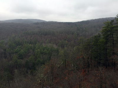
Many species require large, unbroken tracts of forest, offering deep interior forest conditions, to carry out some portion of their life cycle. A variety of song birds depend on Maryland’s interior forests. Some of them are neotropical migrants, whose summer habitat here and winter habitat in tropical areas are increasingly threatened. Many unique and rare plant and animal communities are also threatened by habitat fragmentation which can increase the risk of predation or the displacement of native species by invasive, exotic species.
Data and Mapping
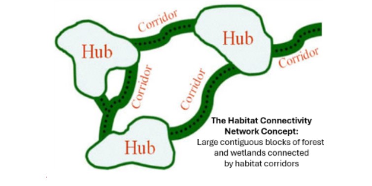
Since a statewide comprehensive approach to address landscape fragmentation did not exist, Maryland’s Department of Natural Resources (DNR) began an effort in the late 1990’s to identify the most ecologically important lands in the State. DNR selected Forest Interior Dwelling Species (FIDS) to set landscape scale conservation priorities for the State. By acting upon the habitat needs of species at greatest risk from forest fragmentation, DNR is also able to address the accompanying ecosystem services and other species habitat needs that are also dependent upon large blocks of intact habitat. The result of this effort is a mapped network of large blocks of intact forest and wetlands, called “hubs,” linked together by linear features such as forested stream valleys, ridgelines, or other natural areas, called “corridors.” An essential characteristic of the habitat connectivity network is the interconnection of its features.
Size thresholds for hubs and corridors were based on the conservation needs of Maryland FIDS.
- Hubs were defined as contiguous forest blocks and wetland complexes of at least 50 acres; rare or sensitive species habitats, biologically important rivers and streams, and existing conservation lands managed for natural values.
- Corridors are at least 1100 feet wide and follow the best ecological or most natural routes between hubs to help animals, plant seeds, water and other important processes move between hubs.
An important function of the Habitat Connectivity Network is to provide maps which government agencies and public and private conservation groups can use to help focus their efforts on strategic locations. Working together in a more coordinated way will help limited conservation dollars go further and result in more ecologically valuable purchases.
The Habitat Connectivity Network (HCN), based on principles of landscape ecology and conservation biology, identified an ecological network using satellite imagery to characterize land cover, biological databases, and Geographic Information System (GIS) data on road, stream, wetland and other resource features. The model and resulting maps were peer reviewed by scientists and local government staff. Non-natural gaps in the GI were identified as potential candidates for restoration activities.
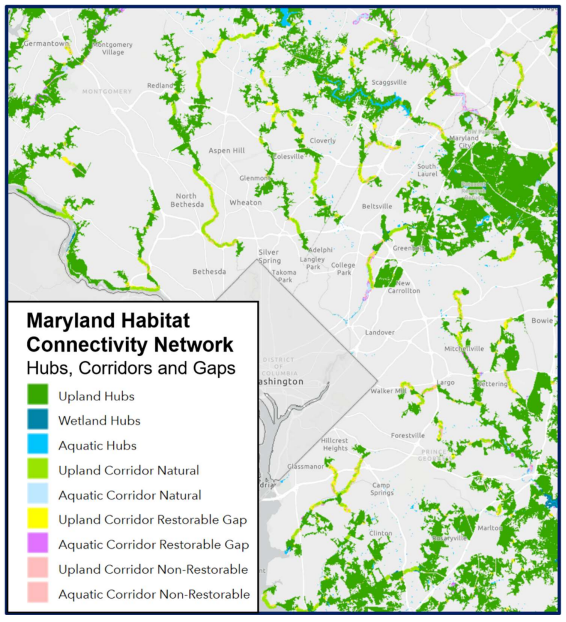
When complete, the HCN map comprised approximately 2.2 million acres in hubs and roughly 250,000 acres of corridors, totaling about 38% of the State’s land area. The network captures nearly all of Maryland’s most important ecological lands. HCN data and maps are readily available for agencies and organizations interested in conserving Maryland’s critical natural resources.
2024 Update of the Habitat Connectivity Network
Maryland’s Habitat Connectivity Network (previously known as Green Infrastructure) was first produced in 2005, with updates to hub areas in 2011. The 2024 update leverages the Chesapeake Bay Program's cutting-edge, high-resolution 2017/2018 land use/land cover mapping and provides several additional enhancements, including differentiation of hub and corridor types (forest, wetland, or aquatic), a breakdown of land cover types within corridors, and identification of potentially restorable gaps within corridors. The updated Habitat Connectivity Network map layer can be viewed on the Maryland GreenPrint web map (https://geodata.md.gov/greenprint/). The data layer can be downloaded from the Maryland iMap Data Catalog. An archived version of the original Green Infrastructure data can be accessed
here.
Like the Green Infrastructure before it, the Habitat Connectivity Network is now incorporated as one of the factors used to evaluate potential acquisitions through DNR’s land conservation programs. The HCN provides essential information for environmental planning to support Maryland DNR and its private and public partners.
As of 2025, DNR land conservation programs including Program Open Space, the Rural Legacy Program, and the Maryland Environmental Trust have protected over 690,000 acres of land through the acquisition of fee-simple lands and conservation easements statewide. Partner organizations including local governments, the federal government, and public and private conservation groups also protect natural areas from development. Many of these lands are incorporated in the mapped Habitat Connectivity Network.
Other Natural Area Data Sets
In addition to the Habitat Connectivity Network, the DNR had developed three other statewide databases based upon extensive scientific work. Like the Habitat Connectivity Network, each database identifies ecological attributes of land throughout the state:
- The Rare Species Habitat database includes additional habitats that support rare, threatened and endangered species.
- The Aquatic Life Hotspots database adds watershed land and streams that support areas of high aquatic biodiversity.
- The Water Quality Protection database focuses on those watershed lands, such as forests, wetlands and steep slopes that are most important for improving water quality services.
The GreenPrint map displays Targeted Ecological Areas (TEAs), lands and watersheds of high ecological value that have been identified as conservation priorities by the Maryland Department of Natural Resources (DNR). It also displays information about four of Maryland’s most active State operated land conservation programs: Program Open Space (POS) Stateside, the Maryland Agricultural Land Preservation Foundation (MALPF), the Maryland Environmental Trust (MET), and the Rural Legacy Program. The TEAs were developed in 2008 and then updated in 2011. This map shows the 2011 version of the TEAs. Therefore, some older acquisitions may not appear in the TEAs, even though they were acquired using the TEAs available at that time. The maps also display other protected land data for reference.
