Bay Scallop Populations in the Maryland Coastal Bays
Mitchell L. Tarnowski and Mark L. Homer
Maryland Department of Natural Resources Shellfish Program
OVERVIEW
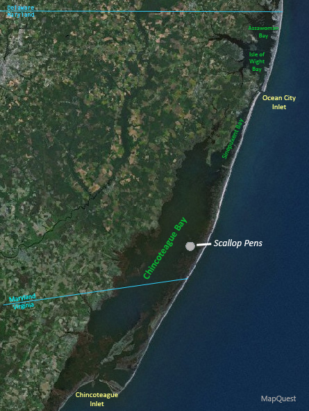 The Maryland coastal bays are a series of interconnected shallow lagoons extending along the entire Atlantic coast of the state and linked to the ocean by two narrow inlets (Figure 1). In the past, bay scallops in these bays have occurred episodically, tied to the ephemeral openings of inlets and the resultant changes in the salinity regimes and habitat in this lagoonal system. Ancient, blackened shells found on Assateague Island, the barrier island separating Sinepuxent and Chincoteague Bays from the Atlantic Ocean, as well as those collected throughout the bays during Maryland Department of Natural Resources (MDNR) hard clam surveys, provide ample evidence that bay scallops have inhabited this region from time to time.
Unlike oysters and hard clams, which have commercial landing statistics and anecdotal information about them from this region dating to the mid-19th century, records on bay scallops prior to the 1900's are not found in period publications (Earll 1887; Ingersoll 1881, 1887; Murphy 1960). However, their presence or absence may be inferred from accounts of inlets. While no inlets existed in the northern bays during the latter half of the 1800's, a series of inlets opened and closed in Chincoteague and lower Sinepuxent Bays (Truitt 1968; Counts & Bashore 1991). The last of these transient inlets, Green Run Inlet in mid-Chincoteague Bay, existed for about 20 years (Truitt & Les Callette 1977) and probably provided adequate salinity for bay scallops. After it closed by the 1880's, the coastal bays were left with only one opening to the ocean, at Chincoteague, Virginia - the southern extreme of the system. Consequently, salinities dropped to the point that oysters, and by inference bay scallops, could not be supported north of Chincoteague Bay (Grave 1912). Nevertheless, the Virginia portion of Chincoteague Bay, in close proximity to the inlet, maintained higher salinities along with lush eelgrass (Zostera marina) meadows inhabited by bay scallops (Henderson & Bartsch 1914). A lucrative bay scallop fishery (1.4 million pounds landed in 1930) developed during the 1920's, based around Chincoteague Island, Virginia (Fieldler 1931; Gutsell 1930). Due to the steep salinity gradient in Chincoteague Bay, the scallop population in Maryland likely was small and restricted to just above the Virginia state line. There were no reported landings in Maryland during this period (Fieldler 1931, 1932, 1933).
Two cataclysmic events with profound implications for bay scallops in coastal Maryland occurred during the early 1930's. In 1933, a storm created an inlet, later stabilized, near Ocean City, raising salinities throughout the coastal bays to levels ideal for bay scallops (Conserv. Dept. Md. 1934). Unfortunately, between 1931 and 1933 what was called "wasting disease" devastated the eelgrass beds in the region (Comm. Fish. Va. 1932, 1934). With the loss of this crucial bay scallop habitat, landings from the seaside bays of Virginia dropped to zero by 1933 (Fieldler 1935). Despite the favorable salinities, the inability of eelgrass to colonize these newly available areas, along with the disappearance of proximal scallop broodstock, inhibited the establishment of bay scallop populations in Maryland for decades.
The re-establishment of eelgrass was slow and sporadic, and by the late 1960's there were only about 1,000 ha of combined eelgrass and widgeongrass (Ruppia maritima) in Chincoteague Bay (Anderson 1970). During this period bay scallops were observed in the southeastern portion of Chincoteague Bay as far north as Green Run Bay (Boynton 1970), but this population soon collapsed.
RE-INTRODUCTION PROJECT
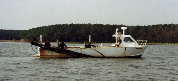
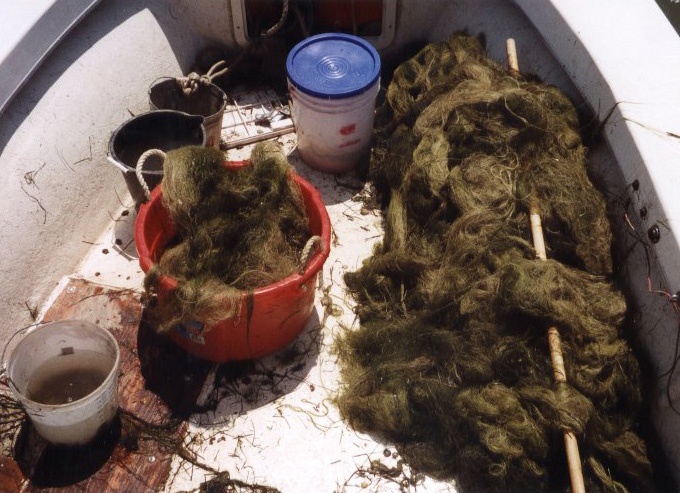
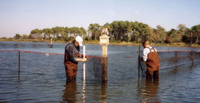 The mid-1980's through the 1990's witnessed the extraordinary spread of seagrasses (primarily eelgrass but also widgeongrass) in the coastal bays. The area of seagrass habitat in Chincoteague Bay alone climbed from 2100 ha in 1986 to a peak of 6794 ha in 2001 (Orth et al. 2006). As a consequence of these advantageous conditions, in 1997 and 1998 MDNR planted a total of 1.2 million hatchery-reared seed scallops in mid-Chincoteague Bay. Protected in large (total area of 3,643 m2), fenced predator exclosures, they served as a source of concentrated broodstock to facilitate establishing a natural population. Concurrently, an unrelated group of wild scallops was reported from the Virginia side of Chincoteague Bay and eventually turned up in the southernmost portion of Maryland. Scallop progeny were monitored as part of the MDNR annual hard clam survey using a commercial clamming vessel equipped with a hydraulic escalator dredge. In addition, more intensive sampling specifically directed towards scallops was conducted in known scallop areas on an opportunistic basis.
RESULTS
 Mimicking the pattern of seagrass expansion a decade earlier, the geographic spread of the scallop population occurred relatively rapidly in a northerly fashion. In 2000, one-year old scallops were observed at Striking Marsh in the vicinity of the exclosures. The following year scallops were found in Sinepuxent Bay, and by 2002 they occurred north of the Ocean City Inlet, probably for the first time in well over a century. Their widest distribution was in 2002, when scallops inhabited four of the five major coastal bays (the fifth, Newport Bay, lacked suitable habitat). Thereafter their range began to contract, to the point that since 2005 no scallops have been found in Chincoteague Bay, which ironically has the greatest amount of eelgrass habitat and the least development of the coastal bays, and was the first bay with an established scallop population
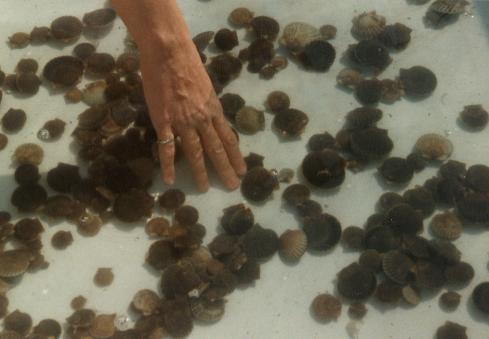 Average scallop densities were calculated only from stations with submerged aquatic vegetation (SAV) habitat (specifically eelgrass, as widgeongrass occurred in shallower waters inaccessible to the clam vessel). Over time the population has remained sparse - the highest density was 770 scallops/ha-SAV, recorded in 1998 at the Virginia state line. For the generalized hard clam survey, between 2000 and 2007 the annual average scallop densities at all stations with SAV peaked in 2003 at 115/ha-SAV, then crashed to a low of 7/ha-SAV in 2006. The highest density for an entire embayment was 602/ha-SAV in Isle of Wight Bay (2003).
The 2008 surveys were somewhat more encouraging, showing sharp increases in scallop population in the northern bays. Scallops were found from lower Sinepuxent Bay up through Isle of Wight and Assawoman Bays almost to the Delaware state line, a distance of about 25 km. The scallops were distributed in two large, discrete patches rather than over a continuous area, due to unfavorable habitat in lower Isle of Wight Bay. Bay scallops in Sinepuxent Bay probably occurred further north than where they were observed, but because of the random-sampling protocol and depth constraints no upper Sinepuxent stations were located in seagrass beds. The 2008 hard clam survey averaged 124 scallops/ha-SAV, although the total number of stations with seagrass habitat was only 18. Combined hard clam and scallop-specific surveys yielded 108 scallops/ha-SAV in Isle of Wight Bay, 237 scallops/ha-SAV in Sinepuxent Bay, and 330 scallops/ha-SAV in Assawoman Bay. Within these three bays, 31 stations with seagrass totaling 3023 m2 were sampled. For the third straight year, no scallops were caught in Chincoteague Bay, despite extensive and directed intensive sampling in likely scallop areas.
GENERAL DISCUSSION
 Several factors may account for the loss and continued absence of bay scallops in Chincoteague Bay. Aureococcus anophagefferens (brown tide) blooms have increased in intensity in recent years, with the most severe blooms in Chincoteague Bay (Glibert et al. 2007). At a monitoring station at Public Landing in mid-Chincoteague Bay, seven of the eight years from 1999 through 2006 had Category 3 blooms with cell counts exceeding 200,000/ml (MDNR, unpubl. data). Brown tide blooms of this magnitude can seriously impact bay scallop populations by causing recruitment failures and high larval and adult mortalities (Gastrich & Wazniak 2002). In addition, between 2004 and 2006 eelgrass suffered a 44% die-off in Chincoteague Bay; the northern bays did not experience this substantial decline in habitat (Orth et al. 2007). This event was associated with abnormally high temperatures reaching at least 34°C (MDNR, unpubl. data) which, along with degrading water quality and the poor flushing characteristics of Chincoteague Bay (Wazniak et al. 2007), may have also impacted the scallop population. Furthermore, predation may have increased, exacerbated by the loss of habitat. In 2005, blue crab landings, used as a surrogate for abundance, were the highest in 25 years (MDNR, unpubl. data). Other predators such as cow-nose rays may also be more abundant (Myers et al. 2007). Given the enigmatic and volatile nature of this species, it is impossible to predict the direction of future trends in this population, save to say that after nearly 16 years its current status remains tenuous.
- Anderson, R.R. 1970. The submerged vegetation of Chincoteague Bay.
In: Assateague Ecological Studies Final Report, Part I: Environmental Information. Natural Resources Inst. Contrib. no. 446, Univ. of Md.
- Boynton, W. 1970. The commercial fisheries of Chincoteague Bay – past, present and future. In: Assateague Ecological Studies Final Report, Part I: Environmental Information. Natural Resources Inst. Contrib. no. 446, Univ. of Md.
- Commission of Fisheries of Virginia. 1932. Thirty-fourth annual report for the fiscal year ending June 30, 1932, p. 7.
- Commission of Fisheries of Virginia. 1934. Thirty-fifth annual report for the fiscal year ending June 30, 1933, p. 13.
- Conservation Department of the State of Maryland. 1934. Twelfth annual report, p. 29.
- Counts, C.L. & T.L.Bashore. 1991. Mollusca of Assateague Island, Maryland and Virginia: A reexamination after seventy-five years. Veliger 34: 214-221.
- Earll, R.E. 1887. Maryland and its fisheries.
In: G.B. Goode (ed.). The Fisheries and Fishery Industries of the United States. Sec. II. A geographic review of the fisheries industries and fishing communities for the year 1880. U.S. Comm. of Fish and Fisheries, U.S. Gov. Print. Office, Wash., D.C.
- Fieldler, R.H. 1931. Fishery Industries of the United States – 1930. U.S. Dept. of Commerce, Bur. of Fisheries, U.S. Gov. Print. Office, Wash., D.C.
- Fieldler, R.H. 1932. Fishery Industries of the United States – 1931. U.S. Dept. of Commerce, Bur. of Fisheries, U.S. Gov. Print. Office, Wash., D.C.
- Fieldler, R.H. 1933. Fishery Industries of the United States – 1932. U.S. Dept. of Commerce, Bur. of Fisheries, U.S. Gov. Print. Office, Wash., D.C.
- Fieldler, R.H. 1935. Fishery Industries of the United States – 1934. U.S. Dept. of Commerce, Bur. of Fisheries, U.S. Gov. Print. Office, Wash., D.C.
- Gastrich, M. & C.E.Wazniak. 2002. A brown tide bloom index based on the potential harmful effects of the brown tide alga,
Aureococcus anophagefferens. AEHMS 5(4): 435-441.
- Glibert, P.M., C.E. Wazniak, M.R. Hall, & B. Sturgis. 2007. Seasonal and interannual trends in nitrogen and brown tide in Maryland's coastal bays. Ecol. Appl. 17: S79-S87.
- Grave, C. 1912. Fourth Report of the Shell Fish Commission of Maryland, pp. 242 - 246.
- Gutsell, J.S. 1930. Natural history of the bay scallop. Bull. U.S. Bur. Fish. 46: 569-632.
- Henderson, J. & P. Bartsch. 1914. Littoral marine mollusks of Chincoteague Island, Virginia. Proc. U.S. Nat. Mus. 47: 411-421.
- Ingersoll, E. 1881. The oyster industry.
In: G.B. Goode (ed.), The History and Present Condition of the Fishery Industries. U.S. Gov. Print. Office, Wash., D.C.
- Ingersoll, E. 1887. The oyster, scallop, clam, mussel, and abalone industries. In: G.B. Goode (ed.). The Fisheries and Fishery Industries of the United States. Sec. II. A geographic review of the fisheries industries and fishing communities for the year 1880. U.S. Comm. of Fish and Fisheries, U.S. Gov. Print. Office, Wash., D.C.
- Murphy, G.J. 1960. Commercial Fisheries Catch Statistics of Major Species Landed in Worcester County, Maryland 1890-1958. Md. Dept. of Res. and Ed., Ches. Biol. Lab, Ref. No. 60-5.
- Myers, R.A., J.K. Baum, T.D. Shepherd, S.P. Powers, & C.H. Peterson. 2007. Cascading effects of the loss of apex predatory sharks from a coastal ocean. Science 315: 1846-1850.
- Orth, R.J., M.L. Luckenbach, S.R. Marion, K.A. Moore, & D.J. Wilcox. 2006. Seagrass recovery in the Delmarva Coastal Bays, USA. Aquat. Bot. 84: 26-36.
- Orth, R.J., D.J. Wilcox, L.S. Nagey, A.L. Owens, J.R. Whiting, & A.K. Kenne. 2007. 2006 distribution of submerged aquatic vegetation in Chesapeake Bay and Coastal Bays. Virginia Institute of Marine Science special scientific report number 150. VIMS, Gloucester Pt., Virginia.
- Truitt, R.V. 1968. High Winds…High Tides. A Chronicle of Maryland's Coastal Hurricanes. Natural Resources Inst., Educ. Ser. No. 77, Univ. of Md., 35 pp.
- Truitt, R.V. & M.G. Les Callette. 1977. Worcester County, Maryland's Arcadia. Worcester Co. Hist. Soc., Snow Hill, Md., 579 pp.
- Wazniak, C.E., M.R. Hall, T.J.B. Carruthers, B. Sturgis, W.C. Dennison, & R.J. Orth. 2007. Linking water quality to living resources in a mid-Atlantic lagoon system, USA. Ecol. Appl. 17: S64-S78.
