Definition
Annotated Code of Maryland, Environment Article, Title 16. Wetlands and Riparian Rights (§16-10l) defines:
State Wetlands — “State wetlands” means any land under the navigable waters of the State below the mean high tide, affected by the regular rise and fall of the tide. Wetlands of this category which have been transferred by the State by valid grant, lease, patent or grant confirmed by Article 5 of the Maryland Declarations of Rights shall be considered “private wetland” to the extent of the interest transferred.
Private Wetlands — (1) “Private wetlands” means any land not considered “State wetlands” bordering on or lying beneath tidal waters, which is subject to regular or period tidal action and supports aquatic growth. (2) “Private wetlands” includes wetlands, transferred by the State by a valid grant, lease, patent or grant confirmed by Article 5 of the Maryland Declaration of Rights, to the extent of the interest transferred.
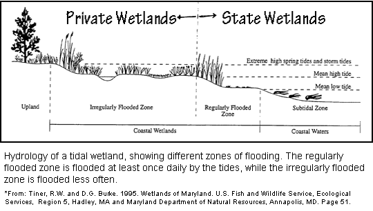
DIAGRAM 1: HYDROLOGY OF A TIDAL WETLAND
The drawing above depicts the hydrology of a tidal wetland, showing different zones of flooding. The regularly flooded zone is flooded at least once daily by the tides, while the irregularly flooded zone is flooded less often.
(Drawing adapted from: Tiner, R. W. and D. G. Burke. 1995. Wetlands of Maryland. U.S. Fish and Wildlife Service, Ecological Services, Region 5, Hadley, MA and Maryland Department of Natural Resources, Annapolis, MD. Page 51)
In general terms and as shown in the diagram above, State tidal wetlands (may be referred to as low marsh) are those areas subject to the daily ebb and flow of the tide. Private tidal wetlands (may be referred to as high marsh) are those areas subject to tidal inundation on a less frequent basis, sometimes monthly and sometimes annually (e.g., during Spring tides). There is a common misconception that all vegetated wetlands are private and only open water areas are regulated as State tidal wetlands. It should be noted that many areas of wetland vegetation are considered State tidal wetlands.
Making the Determination
Acceptable Methods (may vary from site to site):
- Vegetative analyses of the wetlands using accepted survey methods, transects, etc.
- Where vegetative indicators are ambiguous, established NOAA benchmarks and tide data (if the tide station is close enough) can determine the elevation of mean high tide.
- If tidal information is unavailable, an on-site tide station, along with NOAA benchmarks and vegetative analyses.
Needed Documentation
A professional should document how the determination was made, either as part of the required environmental report or separately. It should include a description of the survey methods, a description of findings and conclusions, benchmark and/or tide station data and a graphical depiction of the results. The State/private boundary should be flagged in the field and then surveyed. A Jurisdictional Determination from the Army Corps of Engineers does not distinguish between State and private wetlands and may not be sufficient to document ownership.
If a property owner is claiming ownership via a valid land patent or King’s grant, documentation from the Commissioner of Land Patents must be provided.
Why Does It Matter?
Determining whether a tidal wetland is State or private should be part of the environmental analysis performed prior to evaluating the development potential of a property. This determination is important because it affects the acreage of the property that can be used for various calculations including density.
Private Wetlands - Can be included in the gross site acreage for Critical Area calculation purposes.
State Wetlands - Are not privately owned, cannot be used for Critical Area calculation purposes, and should not be included within the boundaries of a private parcel, tract, or lot.
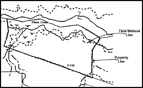
Illustrative Example
In the illustration above, the deed and tax records indicate that parcel 116 has a total acreage of 165 acres. The property has a Critical Area designation of Resource Conservation Area (RCA). A preliminary boundary survey shows a property line in the center of the open water of Pike’s Creek and 68 acres are shown as “tidal wetlands” without any additional documentation.
There is no valid land patent or King’s grant for the property. The property owner is proposing to create eight (8) lots at one dwelling unit per 20 acres. A determination regarding private or State wetlands is necessary in order to:
- Calculate allowable density
- Determine permitted lot coverage
- Calculate afforestation or reforestation requirements
In the example above, there are several important Critical Area issues. If the 68 acres labeled as tidal wetlands are below mean high water (MHW) and are determined to be State wetlands, allowable density on the remaining 97 acres of the property at one dwelling unit per 20 acres is four (4) dwelling units. The allowable lot coverage and afforestation or reforestation requirements would also be based on 97 acres.
If all 68 acres of tidal wetlands are determined to be above MHW, allowable density would be the eight dwelling units proposed. (Natural Resources Article, §8-1808.1, “In calculating the 1-in-20 acre density ... a local jurisdiction may permit the area of any private wetlands on the property to be included ... the density of development on the upland portion of the parcel may not exceed 1 dwelling unit per 8 acres.”) Allowable impervious coverage and afforestation requirements would be based on the entire 165 acres.
It is easy to see that property lines extend into open water. The open water portion of the property would be considered State tidal wetlands. On the remaining land, it is likely that there would be some State tidal wetlands and some private tidal wetlands. Generally a professional with a background in the natural sciences and experience in wetland delineations would be hired to determine the split between private and State tidal wetlands based on the acceptable methods described above. The acreage of State tidal wetlands would be surveyed, the property boundaries adjusted to exclude the wetlands, and the State tidal wetland acreage would not be included in the gross area calculations for the property.
How is the Critical Area Buffer Affected?
The Critical Area Buffer is drawn from the edge of tidal wetlands, regardless of whether the wetlands are private or State. The edge of tidal wetlands is identified in the field either by a change in elevation or by a change in vegetation. When an abrupt and obvious change in elevation is not present, vegetation can be used to determine when a system is not regularly influenced by the tide. Certain types of vegetation require regular inundation by salty or brackish water to grow. On a property with an adjacent tidal marsh, the Buffer is drawn landward beginning at the edge of the tidal marsh. Sometimes this limit can be easily identified as the line where the marsh grass ends and forest or field vegetation begins. On other sites, different types of grasses and shrubs are used to determine the extent of tidal wetlands. Some wetland systems are complex and include intermingled areas of State and private tidal wetlands. On other sites, areas of nontidal wetlands will be adjacent to tidal wetlands. For complex systems of mixed wetland types, it is recommended that an applicant work with a wetlands consultant as part of the environmental analysis.
