Questions?

... or information about the Critical Area Program or questions relating to State oversight of local programs, e-mail us or call 410-260-3460

 CAC logo

Critical Area Commission
1804 West Street
Annapolis, MD 21401

Telephone:410-260-3460
Fax:410-974-5338

Background and History

Skipjacks


​​​​​

The Chesapeake Bay, the largest and most productive estuary in the United States, is Maryland's grandest natural resource. The Bay drains a watershed of more than 64,000 square miles within which dwell more than 13 million people. Its ecosystem provides habitat for about 2700 species of plants and animals. The Bay's seemingly limitless bounty has encouraged the development of commercial activities as varied as fishing, shipbuilding, agriculture, steel-making, manufacturing and chemical production.
The intensity of this development has caused a dramatic reduction in the health of the Bay ecosystem. The major environmental problems of the Chesapeake Bay and its tributaries were investigated in a comprehensive study initiated by the Environmental Protection Agency (EPA) in 1975. The study's final research findings and recommended remedial strategies were published in September 1983. They formed the foundation for the first Chesapeake Bay Agreement by which the governments of Maryland, Virginia, Pennsylvania and the District of Columbia, in partnership with the federal government, agreed to develop and implement coordinated plans to improve and protect the water quality and living resources of the Bay.

The EPA study especially recognized that land use and population growth are major factors in shaping the historical decline in the living resources of the Bay. The number of people living around the bay determine the demands placed on its ecosystem and those demands are growing. Both water quality and wildlife habitat can be seriously degraded by the cumulative impact of intensified development from this increase in population. In 1984, to safeguard the Bay from the negative impacts of intense development, the Maryland General Assembly enacted the Chesapeake Bay Critical Area Protection Program, a far-reaching effort to control future land use development in the Chesapeake's watershed. The ribbon of land within 1000 feet of the tidal influence of the Bay was determined to be crucial because development in this "critical area" has direct and immediate effects on the health of the Bay.

The Chesapeake Bay Critical Area Commission was charged with devising a set of criteria which would minimize the adverse effects of human activities on water quality and natural habitats and would foster consistent, uniform and more sensitive development activity within the Critical Area. In cooperation with the Critical Area commission, local critical area management programs are administered by the 61 local governments whose jurisdiction are partially or entirely within the Critical Area.​​​​​​​

​More Information​

Development in the Critical Area


Overview

All land within the Critical Area, except for land owned by the federal government, is assigned one of three land classifications based on the predominant land use and the intensity of development at the time it was mapped. These provisions are used to ensure that land within the Critical Area is managed, used, and developed in a manner that will achieve the goals of the Critical Area Program.


Land Classifications

  • Intensely Developed Areas (IDAs)

    Intensely Developed Areas (IDAs) are defined as areas of twenty or more adjacent acres where residential, commercial, institutional or industrial land uses predominate. In IDAs, the main focus of the Critical Area Program is on improving water quality. The Law requires that new development and redevelopment include techniques to reduce pollutant loadings associated with stormwater runoff. These techniques include site design, infiltration practices, and structural stormwater treatment practices such as sand filters and swales.

    The Critical Area regulations for IDAs require that designated Habitat Protection Areas be identified and conserved and promote the use of clustering of development to reduce the amount of impervious surfaces and increase the area of natural vegetation. There are no clearing limits and no lot coverage limits within IDAs; however urban forestry programs that minimize the destruction of forest and woodland vegetation and benefit water quality by controlling sediment, reducing runoff and removing nutrients are encouraged.

  • Limited Development Areas (LDAs)

    Limited Development Areas (LDAs) are areas characterized by low or moderate intensity development, but that also contain areas of natural plant and animal habitats. Generally, the quality of runoff from these areas has not been substantially altered or impaired. In order for an area to be classified as LDA at the time it was mapped, it had to have housing density between one dwelling unit per five acres and four dwelling units per acre; have public water or public sewer or both; or have IDA characteristics but consist of fewer than 20 acres.

    Within LDAs, the Critical Area regulations permit development and redevelopment that is consistent with the prevailing character of land use as determined by the jurisdiction. Local zoning regulations specify what uses and residential densities are permitted.

    Generally, lot coverage in the LDA is limited to 15 % of the parcel or lot, or of the subdivision or development project as a whole. Lot coverage is defined as the percentage of a lot or parcel that is occupied by structures, parking areas, roads, walkways, pavers, gravel, or any man-made material. (Decks through which water passes freely do not count towards lot coverage calculations.) For lots under one-half acre that were created prior to the effective date of the Critical Area regulations, lot coverage is limited to 25 % of the parcel or lot with some exceptions. The local government can provide specific information regarding these allowances.

    The Critical Area regulations require that all development projects include the replacement of cleared forest cover in ratios ranging from 1:1 to 3:1, depending on the percentage of forest acreage cleared. When it is impossible to replace forest cover on the project site, local jurisdictions collect fees-in-lieu that are used to reforest other areas in the Critical Area or other locations beneficial to the Critical Area. In areas of new development or redevelopment, where no forest coverage existed prior to development, for example when a subdivision is platted on agricultural lands, 15% of the area must be planted with trees.

    In order to protect water quality in LDAs by managing runoff and controlling erosion in LDAs, local Critical Area regulations prohibit development and disturbance in areas where slopes exceed 15%.

  • Resource Conservation Areas (RCAs)

    RCAs make up approximately 80% of the Critical Area and are characterized by natural environments or areas where resource-utilization activities are taking place. Resource-utilization activities include agriculture, forestry, fisheries activities, and aquaculture, which are considered “protective” land uses. In order for an area to be classified as RCA at the time it was mapped, the area would have to be developed at a residential density less than one dwelling unit per five acres or be dominated by agricultural uses, wetlands, forests, barren land, surface water, or open space.

    Within RCAs, new development is limited to residential uses and uses associated with resource utilization activities. In general, new commercial, industrial, and institutional uses are not permitted. Residential density is limited to one dwelling unit per 20 acres because studies have indicated that higher densities create patterns of development that are not compatible with maintaining habitat and protecting water quality. The regulations do not require 20-acre lots, and clustering of development is encouraged.

    Generally, lot coverage is limited to 15% of the parcel or lot, or of the subdivision or development project as a whole. Lot coverage is defined as the percentage of a lot or parcel that is occupied by structures, parking areas, roads, walkways, pavers, gravel, or any man-made material. (Decks through which water passes freely do not count towards lot coverage calculations.) For lots under one-half acre that were created prior to the effective date of the

    Critical Area regulations, lot coverage is limited to 25% of the parcel or lot with some exceptions. The local government can provide specific information regarding theses allowances.

    The Critical Area regulations require that all development projects include the replacement of cleared forest cover in ratios ranging from 1:1 to 3:1, depending on the percentage of forest acreage cleared. When it is impossible to replace forest cover on the project site, local jurisdictions collect fees-in-lieu that are used to reforest other areas in the Critical Area or other locations beneficial to the Critical Area. In areas of new development or redevelopment, where no forest coverage existed prior to development, for example when a subdivision is platted on agricultural lands, 15% of the area must be planted with trees.

    In order to protect water quality in RCAs by managing runoff and controlling erosion in RCAs, local Critical Area regulations prohibit development and disturbance in areas where slopes exceed 15%.

    The Critical Area Program also requires local governments to address agriculture, forestry, fisheries, and aquaculture uses through interagency coordination and the use of Soil Conservation and Water Quality Plans for farms, Timber Harvest and Forest Management Plans for forestry uses, and Water-Dependent Facilities regulations for fisheries and aquaculture.

​​​

Critical Area Partnership


Maryland’s Critical Area Program is unique not only because of the significant resources that it is designed to protect, but because it is one of only a few regulatory land use programs in the country that involve a cooperative implementation effort between State and local governments. The purpose of this arrangement is to provide local governments with the flexibility needed to address the unique physical, economic, and social characteristics of the particular jurisdiction while ensuring that the goals, purposes, policies, and criteria of Maryland’s Critical Area Program are implemented in a consistent and uniform manner throughout the State.
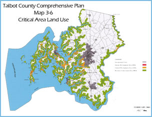
Talbot County Critical Area Map

A Partnership Involving the State and Local Governments

Each jurisdiction with its own planning and zoning authority adopted its own local Critical Area program based on the Criteria promulgated by the Commission. The Critical Area Law recognized the primary responsibility of local governments for land use decisions. By implementing the Law in this fashion, local governments were allowed to add to or modify existing zoning and land use regulations, providing the flexibility necessary to accommodate local conditions. As a result, most jurisdictions’ Critical Area Programs differ substantially from one another.

Local Critical Area Program Development

Each local government was required to develop and submit a program to the Commission by March 1987; and these local programs were to be reviewed, amended, and approved by the Commission by June 1988. The deadline for submittal to the Commission was extended but many jurisdictions did not meet the deadline Ultimately, after many months of intense effort by the Critical Area Commission and local governments, all jurisdictions that were required to have a local program, had one in place by 1990.

The Critical Area Law requires local governments to review their Critical Area programs comprehensively every six years. These reviews are necessary for the Commission to make sure that local programs are kept up to date and that required legislation is incorporated into local codes and ordinances. The reviews also provide an opportunity for local governments to work closely with the Commission to modify provisions of their programs to accommodate new State or local plans or initiatives and to address any specific implementation challenges that they are facing. In addition to changes that are regularly made to local plans and ordinances, many jurisdictions are in the process of revising their Critical Area Maps and converting them to an electronic format. This enables local governments to make use of state-of-the-art technology and provides opportunities to make these resources more accessible to the public.

Local Critical Area Program Implementation

In general, for all development activities on private lands or lands owned by a local government, the local planning and zoning department is the primary agency responsible for reviewing and approving building permits, site plans, and subdivision plans. Private landowners do not have to apply to the Critical Area Commission for approval of development plans or building permits. The Commission does perform an oversight role with respect to local review of projects. Comments and recommendations on such projects are provided to the local government by the Commission in order to aid the local government in the decision-making process.

The Commission also does not function as an independent enforcement authority and does not have its own inspectors. Instead, the Commission works cooperatively with local enforcement officials to assist them in effectively administering and implementing their local Critical Area regulations. In 2004, the Critical Area Law was amended to allow local governments to request assistance from the Office of the Attorney General through the Critical Area Commission to provide assistance in pursuing and remediating serious violations.

The provisions of Maryland’s Critical Area Program are intended to provide general information about the basic requirements and standards included in the Critical Area Law and Criteria. However, it should be noted that each local government has its own locally implemented program, and this guide is not a substitute for local ordinances, codes, regulations, and policies that may be more specific and detailed.