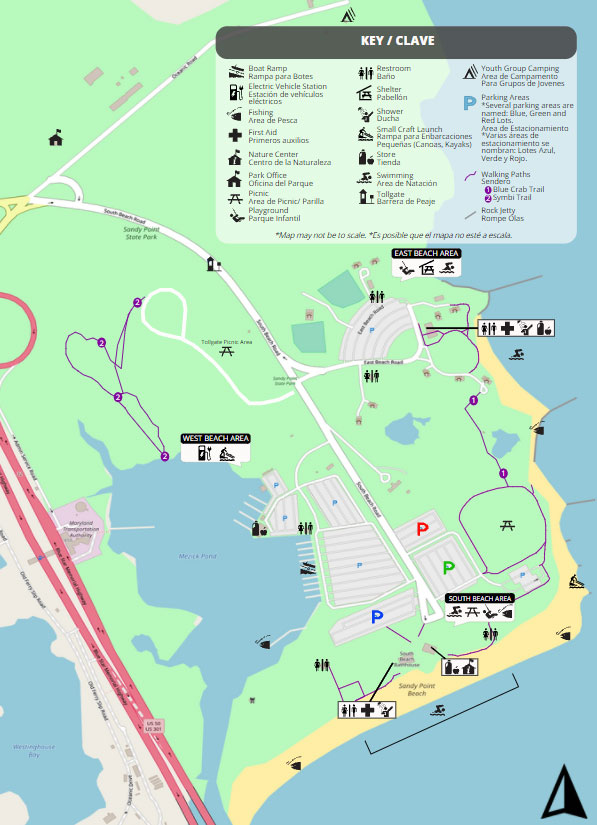
Features available include twenty two boat ramps, one mile of sandy beach front, two short hiking trails, picnic areas with grills, playgrounds, fishing and crabbing piers, small craft launch ramp, shelters ( by reservation only), and guarded swim areas available seasonally.

Directions to Park Facilities
- How do I get to the South Beach area? Follow straight down the road to the end. Parking can be found on the right and left at South Beach. When parking is limited, Rangers will direct beach traffic to available lots.
- How do I get to the East Beach area? Straight down the road, take the first left paved road after the Contact Station. This lot is restricted to visitors who have rented shelters. To learn more about renting a shelter, click here.
- How do I get to the boat launch area? Take the first paved road on the right and follow the road around to the large Marina parking lot. Ramps are at the bottom of the lot in Mezick Pond.
- How do I get to the small craft launching area? Take the first left after the large white house (Mansion) on the left. The launch area is beyond the parking lot at the end of the road. NOTE: Turnoff is marked for small craft launch area. Windsurfers, small sailboats, and kayaks launch from this area.
- How do I get to Park Headquarters? If in the park, go back to the front entrance intersection and make a right. It is the first building on the left. From outside of the park, at intersection either stay straight from Rte 50 or from East College Parkway make a left.
- Are there walking or biking trails? There are two short, self-guided trails in the park. The Symbi trail is behind the Tollgate Picnic area. The Blue Crab trail is between East Beach and South Beach.