The printed version of the Code of Maryland Regulations (COMAR) is the official and enforceable text. Only the official text may be judicially noticed under Courts and Judicial Proceedings, Section 10-203, Annotated Code of Maryland. For the complete, searchable, text of these regulations to access the Maryland Division of State Documents.
08.02.01.06 - Code of Maryland Regulation
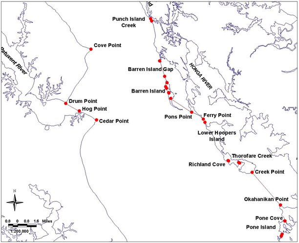
Bay Definition, Map No. 2
.06 Dividing Lines of the Chesapeake Bay, Sounds and Straits.
A. The boundaries set forth in §B of this regulation are designated as official dividing lines of the Chesapeake Bay, sounds and straits.
B. Any creek, cove, or other tributary less than 100 yards in width that intersects any segment of the following delineating lines shall not be a part of the described area.
(1a) Chesapeake Bay, Western Shore. -
Description reads south to north.
Continued south on bay Map #1.
...then running northwesterly along the shore to a point at or near Cedar Point, defined by Lat. 38°17.93' N and Long. 76°22.38' W; then running westerly along the shore to a point at or near Hog Point, defined by Lat. 38°18.59' N and Long. 76°23.99' W; then running approximately 299° True to a point at or near Drum Point, defined by Lat. 38°19.14' N and Long. 76°25.27' W; then running northeasterly along the shore to a point at or near Cove Point, defined by Lat. 38°23.13' N and Long. 76°22.86' W; then running northwesterly along the shore ...
Continued north on bay Map #3.
(1b)Chesapeake Bay, Eastern Shore. -
Description reads north to south.
...then running southeasterly along shore to a point at or near the north entrance of Punch Island Creek, defined by Lat. 38°25.35' N and Long.76°17.26' W; then running approximately 161° True to a point at or near the south entrance of Punch Island Creek, defined by Lat. 38°25.16' N and Long. 76°17.17' W; then running southerly along the shore to a point at or near the north entrance of Barren Island Gap, defined by Lat. 38°22.23' N and Long. 76°16.43' W; then running approximately 163° True to a point at or near the entrance of Barren Island Gap, defined by Lat. 38°21.09' N and Long. 76°15.99' W; then running approximately 159° True to a point at or near Barren Island Point, defined by Lat. 38°20.62' N and Long. 76°15.77' W; then running southerly along the west shore of Barren Island to a point at or near the west shore of Barren Island, defined by Lat. 38°20.32' N and Long. 76°15.89' W; then running approximately 152° True to a point at or near the west shore of Barren Island, defined by Lat. 38°20.21' N and Long. 76°15.82' W; then running southerly along the west shore of Barren Island to a point at or near the west shore of Barren Island, defined by Lat. 38°19.90' N and Long. 76°15.61' W; then running approximately 171° True to a point at or near the west shore of Barren Island, defined by Lat. 38°19.85' N and Long. 76°15.60' W; then running southeasterly along the west shore of Barren Island to a point at or near the south end of Barren Island, defined by Lat. 38°19.46' N and Long. 76°15.43' W; then running approximately 124° True to a point at or near Pons Point, defined by Lat. 38°18.43' N and Long. 76°13.47' W; then running southeasterly along the west shore of Upper Hoopers Island to a point at or near Ferry Point, defined by Lat. 38°17.92' N and Long. 76°12.39' W; then running southeasterly along the Narrows Ferry Bridge to a point at or near the northwesterly point of Lower Hoopers Island, defined by Lat. 38°17.68' N and Long. 76°12.25' W; then running southeasterly along the west shore of Lower Hoopers Island to a point at or near the west side of Richland Cove, defined by Lat. 38°14.85' N and Long. 76°10.11' W; then running approximately 116° True to a point at or near the east side of Richland Cove, defined by Lat. 38°14.84' N and Long. 76°10.07' W; then running easterly along the shore to a point at or near the west side of Thorofare Creek, defined by Lat. 38°14.70' N and Long. 76°09.13' W; then running approximately 118° True to a point at or near the east side of Thorofare Creek, defined by Lat. 38°14.66' N and Long. 76°09.04' W; then running southerly and easterly to a point at or near Creek Point, defined by Lat. 38°13.97' N and Long. 76°07.87' W; then running approximately 140° True to a point at or near Okahanikan Point, defined by Lat. 38°11.54' N and Long. 76°05.26' W; then running southerly along the west shore of Bloodsworth Island to a point at or near the north side of Pone Cove, defined by Lat. 38°10.38' N and Long. 76°04.84' W; then running approximately 246° True to a point at or near the south side of Pone Cove, defined by Lat. 38°10.37' N and Long. 76°04.86' W;...
Continued south on bay Map #1.
