The printed version of the Code of Maryland Regulations (COMAR) is the official and enforceable text. Only the official text may be judicially noticed under Courts and Judicial Proceedings, Section 10-203, Annotated Code of Maryland. For the complete, searchable, text of these regulations access the Maryland Division of State Documents.
08.02.01.06 - Code of Maryland Regulation
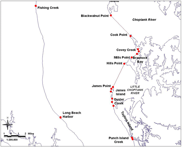
Bay Definition, Map No. 3
.06 Dividing Lines of the Chesapeake Bay, Sounds and Straits.
A. The boundaries set forth in §B of this regulation are designated as official dividing lines of the Chesapeake Bay, sounds and straits.
B. Any creek, cove, or other tributary less than 100 yards in width that intersects any segment of the following delineating lines shall not be a part of the described area.
(1a) Chesapeake Bay, Western Shore.
Description reads south to north.
Continued south on bay Map #2.
...then running northwesterly along the shore to a point at or near the south side of Long Beach Harbor, defined by Lat. 38°27.87' N and Long. 76°28.25' W; then running approximately 358° True to a point at or near the north side of Long Beach Harbor, defined by Lat. 38°27.91' N and Long. 76°28.25' W; then running northerly along shore to a point at or near the south side of Fishing Creek, defined by Lat. 38°41.46' N and Long. 76°31.97' W; then running approximately 314° True to a point at or near the north side of Fishing Creek, defined by Lat. 38°41.48' N and Long. 76°31.10' W; then running northerly along shore...
Continued north on bay Map #4.
(1b)Chesapeake Bay, Eastern Shore.
Description reads north to south.
...then running southerly along the west shore of Tilghman Island to a point at or near Blackwalnut Point, defined by Lat. 38°40.24' N and Long. 76°20.37' W; then running approximately 137° True to a point at or near Cook Point, defined by Lat. 38°37.73' N and Long. 76°17.35' W; then running southeasterly along the west shore of Cook Point to a point at or near the northwest entrance of Covey Creek, defined by Lat. 38°36.11' N and Long. 76°16.23' W; then running approximately 158° True to a point at or near the southeast entrance of Covey Creek, defined by Lat. 38°35.86' N and Long. 76°16.10' W; then running southwesterly along shore to a point at or near the northeast entrance of Brannock Bay, defined by Lat. 38°35.54' N and Long. 76°16.38' W; then running approximately 237° True to a point at or near the southwest entrance of Brannock Bay at Mills Point, defined by Lat. 38°35.11' N and Long. 76°17.21' W; then running southwesterly along shore to a point at or near Hills Point, defined by Lat. 38°34.36' N and Long. 76°18.36' W; then running approximately 206° True to a point at or near the northerly tip of north James Island, defined by Lat. 38°31.54' N and Long. 76°20.14' W; then running along shore to a point at or near James Point, defined by Lat. 38°31.33' N and Long. 76°20.38' W; then running approximately 190° True to a point at or near the northwesterly tip of south James Island, defined by Lat. 38°30.99' N and Long. 76°20.46' W; then running southerly along shore to a point at or near the southerly tip of south James Island, defined by Lat. 38°30.13' N and Long. 76°20.28' W; then running approximately 181° True to a point at or near the westerly entrance of Oyster Creek, defined by Lat. 38°29.72' N and Long. 76°20.29' W; then running approximately 162° True to a point at or near the shore of Taylors Island, defined by Lat. 38°29.25' N and Long. 76°20.09' W; then running southeasterly along shore to a point at or near the north entrance of Punch Island Creek,...
Continued south on bay Map #2.
