Maryland Department of the Environment
Water and Science Administration
Notice of Application for State Wetland Licenses, Private Wetland Permits, Nontidal Wetlands and Waterways Permits and/or Water Quality Certification and the Opportunity to Provide Written Comment or Request an Informational Hearing
The Water and Science Administration is reviewing the following applications for State Wetland Licenses, Private Wetland Permits, Nontidal Wetlands and Waterways Permits and/or Water Quality Certifications. The applications and related information are on file at the Administration. Arrangements may be made for inspection and copying of file materials. Interested parties may provide written comment on the application or request an informational hearing on any listed application. A request for a hearing must be in writing and provide the following information: 1) Name, Address, and Telephone Number of the person making the request; 2) The identity of any other person(s) the requestor is representing; and 3) the specific issues proposed to be considered at the hearing. Please refer to the case number (i.e., 00-WL-0000, 00-WQC-0000) which identifies each application. Address correspondence to: Tidal Wetlands Division, Water and Science Administration, 1800 Washington Boulevard Baltimore, Maryland, 21230. Telephone (410) 537-3571. Written comments or requests for a hearing must be received on or before July 1, 2025, unless otherwise noted in the Public Notice.
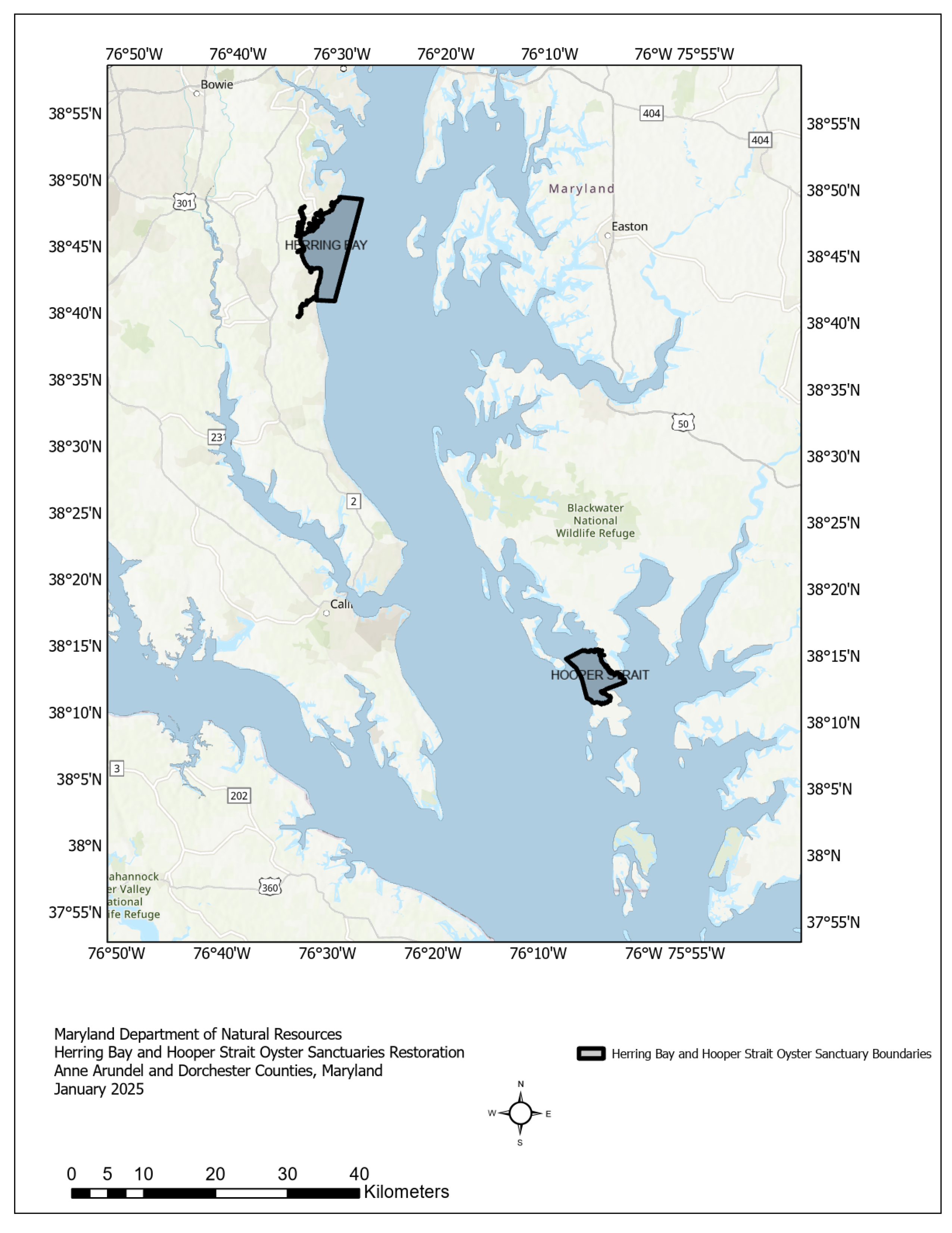
25-WL-0081/202560131: MARYLAND DEPARTMENT OF NATURAL RESOURCES, 580 Taylor Ave., B-2, Annapolis, MD 21409, has applied to restore approximately 1,000 acres of existing oyster bars located in water depths of approximately 8 feet at mean low water (MLW) by depositing approximately 1,613,000 cubic yards of stone and concrete which may include granite, limestone, amphibolite, diorite and concrete rubble, creating a thickness of 12 inches on the river bottom substrate with a minimum clearance of 6 feet at mean low water above the elevation of the alternative substrate material. The project is located on Herring Bay and Hooper Straight in Anne Arundel, Calvert & Dorchester Counties. The purpose of the project is to restore oyster habitat. For more information, please contact Justin Bereznak at
Justin.Bereznak@maryland.gov or 410-537-3782.
Project Locations:
Herring Bay Oyster Sanctuary, Chesapeake Bay Mainstem, Anne Arundel County, Maryland Hooper Strait Oyster Sanctuary, Hooper Strait, Dorchester County, Maryland
Project Purpose and Need: Oysters provide important ecological services, including water filtration and provision of habitat for numerous estuarine species. Maryland’s oyster reefs have been in decline since the mid 1800s due to habitat degradation, harvest pressure, and disease. Current efforts to restore oysters involve large-scale projects.
As a part of the 2014 Chesapeake Bay Watershed Agreement, Maryland committed to restoring oyster populations in five tributaries in Maryland’s portion of the Chesapeake Bay by 2025 (Chesapeake Executive Council 2014). As 2025 approaches and the five tributaries for large-scale restoration are nearing completion of their initial restoration, the Department of Natural Resources (DNR, or the Department) announced its Four Point Sanctuary Plan. This plan commits to additional large-scale restoration. At the October 8, 2024 Oyster Advisory Commission meeting, the Department announced the next three areas for large-scale restoration within Maryland, Herring Bay, Hooper Strait and Nanticoke River oyster sanctuaries. The selection was based on the findings of the U.S. Army Corp of Engineers Master Plan, MD Department of Natural Resources (DNR) Fall Oyster Survey and patent tong survey data, the Maryland oyster sanctuary list, and bottom survey data from the Maryland Geological Survey (MGS) and National Oceanic and Atmospheric Administration (NOAA).
Project Description:
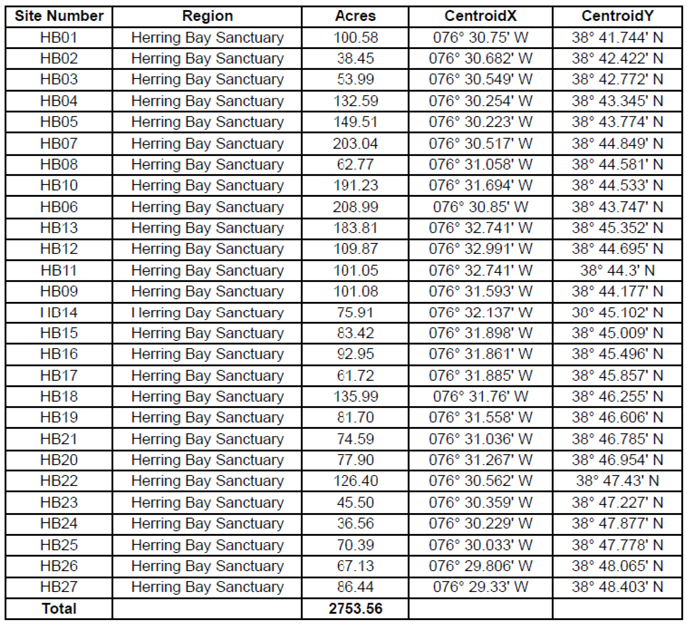
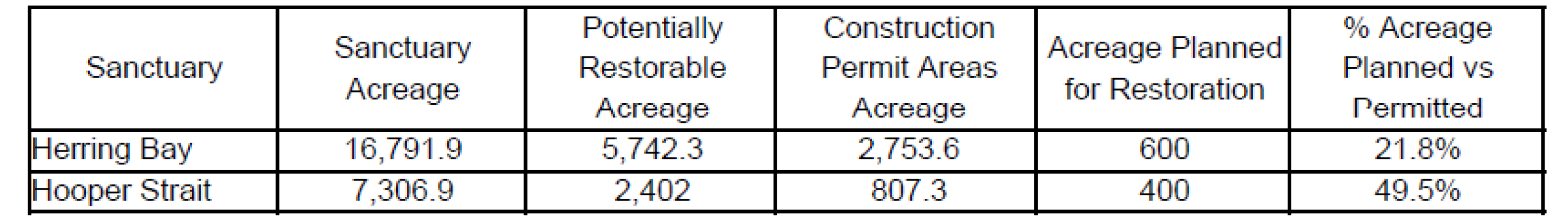
The Hooper Strait Sanctuary could receive up to 400 acres of restoration construction and the Herring Bay Sanctuary could receive up to 600 acres. However, limited funding levels could reduce these numbers considerably. For the purpose of this application 400 and 600 are the maximum values. These acres will be restored by adding substrate up to 12 inches thick to form a reef base, though a lesser thickness might be used based upon site specific situations. A minimum post construction water clearance of six feet depth MLLW will occur above project sites. The substrates for restoration include oyster shell, crushed concrete, and locally sourced stone such as granite, limestone, diorite and amphibolite.
A projected 1,613,000 cubic yards of substrate are needed to implement the restoration plans. This projection assumes that substrate reefs will be built at heights up to 12 inches. Constructing 12‐inch‐high reefs requires 1,613 cubic yards of substrate per acre.
This project includes pre construction bathymetry surveys, substrate deployment, and post construction bathymetry surveys where substrate is placed to ensure that there are no high spots after construction to ensure safe navigation. These bathymetry surveys are discreet from the sonar surveys that MGS and NOAA perform prior to and after restoration and are intended to ensure proper substrate height on the constructed reefs.
Completed Work:
The Baywide Bathymetry Grid developed by the Chesapeake Bay Program and a NOAA sonar survey from 1947-1951 were interpolated to define restoration depths. A depth limit of 6 feet MLLW post-construction was used for substrate placement to allow for safe navigation over the substrate. Benthic habitat was classified using the Coastal and Marine Ecological Classification Standards using the 2012 MGS results. Sounding pole and oyster population surveys will be conducted to groundtruth and determine areas in need of enhancement.
Site Selection:
The Hooper Strait and Herring Bay sanctuaries were chosen for large-scale oyster restoration based on their status as an oyster sanctuary (oyster harvesting prohibited), the availability of restorable bottom (bottom that can support substrate), water quality (dissolved oxygen and salinity appropriate for survival and reproduction), historic oyster populations, proximity to Public Shellfish Fishery Areas (PSFA) and sanctuary size.
Within the sanctuaries, sites were selected based on their ability to support substrate. Exclusion zones were set for submerged aquatic vegetation beds, a buffer area of 150’ from aquaculture leases and pound net sites, and a buffer area of 250’ from navigational aids. Specific reefs to receive restoration will be selected from the areas presented after MGS completes a new Bay Bottom Survey of the sanctuaries and the bottom is verified by groundtruthing the areas. MGS started a new survey of these areas this winter and results should be available to DNR by the spring of 2025. Areas will be chosen based on being suitable for receiving substrate restoration as well as choosing areas that will have the least impact to navigational concerns.
Construction Access and Methodology:
Contractors will access the construction site with boats and barges. Corners of construction areas will be marked with buoys. Material will be located on a barge, and placed on the bottom with either a crane or water cannon.
All areas will have surveys for pre construction bathymetry and post construction bathymetry where substrate is placed to ensure that there are no high spots during construction to ensure safe navigation and compliance to reef construction specifications. These bathymetry surveys are discreet from the sonar surveys that MGS and NOAA perform prior to and after restoration and are intended only to ensure proper substrate height on the construction reefs.