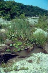
Chesapeake Bay Critical Area Mapping Frequently Asked Questions
 What does it mean to me if I received a letter referring to the Critical Area Map Update and stating the draft maps show a change in the Critical Area boundary on my property?
The letter means that the location of the Critical Area boundary line is being changed on your property and that at least a portion of your property will be subject to the State-mandated Chesapeake and Atlantic Coastal Bays Critical Area law.
What is the County going to do on my property?
The County is not making any physical changes to your property. The Critical Area boundary is a line on a map, just like a zoning line.
Will the map change impact my flood insurance?
The flood insurance program is separately administered by the Maryland Department of
Environment. For information on flood insurance visit:
https://mde.maryland.gov/programs/Water/StormwaterManagementProgram/FloodHazardMitigation/Pages/permitting.aspx
Will the map change increase my property taxes?
Property taxes are separately administered by the County tax assessor’s office. For more information visit your local tax assessor's office
Are my existing structures grandfathered?
Yes. The existing structures and other items on your property making up the lot coverage (formerly impervious surfaces) are grandfathered and do not have to be removed.
Do I need to do anything now because of the map change?
The map change does not require that you do anything right now; however, if you apply for a building permit in the future, you will be subject to the State-mandated Chesapeake and Atlantic Coastal Bays Critical Area law for the portion of your property that will be in the Critical Area. We encourage you to look at the maps online or at one of the public meetings so that you know where the Critical Area boundary will be on your property. The online mapping tool can be found at:
https://webmaps.esrgc.org/cbca/x
We also encourage you to call your local planning office if you have any questions.
