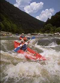
 Navigating the Rapids
The Youghiogheny drains an area encompassing approximately 397 square miles in Maryland. In its first 20 miles, the river meanders through a pastoral setting of farms and wood lots occasionally paralleled by country roads or railroad tracks.
North of the town of Oakland, the character of the river changes as the river valley narrows, deepens, and becomes heavily forested. From Swallow Falls to Hoyes Run, the Youghiogheny enters a stretch of falls and rapids with a drop in elevation of 280 feet in four miles.
At Hoyes Run, a relatively smooth stretch of river can be found all the way to Gap Falls, just north of Sang Run. At that point, the most rugged and inaccessible section of the river runs wild and free to the town limits of Friendsville, dropping in elevation on average over 100 feet per mile.
Whitewater Boating
Whitewater boating has become an increasingly popular way for many to experience the wildness of the Youghiogheny. The river is extremely difficult and potentially dangerous and must be treated with respect. Information on whitewater boating may be obtained at the park office.
Rafting Companies
Upper Yough Expeditions: 800-248-1893
Precision Rafting: 800-477-3723
Ohiopyle Trading Post and River Tours: 724-329-1450
Wilderness Voyageurs: 800-272-4141
White Water Adventures: 724-329-8850
Laurel Highlands River Tours: 800-472-3846
Brookfield Power
Brookfield Renewable Power owns and operates the hydroelectric power plant on Deep Creek Lake.
The whitewater release schedule is posted there as well as the lake elevation of Deep Creek Lake and other interesting information about the creation of the dam and history of the project.