Developed by The Friends of Patapsco Valley State Park, and The Maryland Park Service.
Many floods have destroyed much of the Valley’s industries and milltowns, but if you look closely you can find clues and the remains of these once vibrant communities.
Introduction
In this Valley, layer upon layer of history tells the story of man's interaction with nature. Native Americans gathered, hunted and fished here for centuries. Early colonists planted tobacco and built iron furnaces, forges and mills. They felled the trees for farms and to make charcoal. The charcoal was used to fire the iron furnaces. Towns, dams, mills and factories grew. At each location sewage, dyes and waste products were dumped into the river. Then, as if to cleanse itself of its polluted and denuded state, the river destroyed most of all that man had developed in its valley with the catastrophic flood of 1868.
Conservation efforts began in the Patapsco River Valley when Patapsco State Forest Reserve was established in 1907. In the 1930's, the Civilian Conservation Corps (CCC) planted trees, built trails, picnic and camp sites and handsome cut stone pavilions to improve what was then called "Patapsco State Park."
In the 1950's, this popular Patapsco State Park began to expand both in acreage and in numbers of recreation areas. However, the park suffered a severe setback in 1972 when Tropical Storm Agnes destroyed all park improvements along the valley's floor. As a result of Storm Agnes, the state park began an extensive reconstruction of recreation facilities and at the same time the park's acreage consistently increased as a result of Maryland's Program Open Space. From 1970 to present times, the park doubled in size to 16,000 acres protecting the Valley's watershed.
The river's water quality has improved since a new county sewer line was installed in the 1970's after Tropical Storm Agnes. Nearly all dams have been removed in recent years, and shad and herring can now spawn upstream for the first time in 150 years. Now, with that introduction, we begin our self-guiding tour at the Patapsco History Visitor Center.
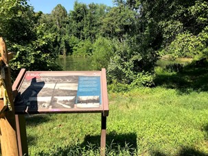
Stop #1 Thomas Viaduct and the Offutt Johnson Visitor’s Center: Patapsco History Visitor Center.
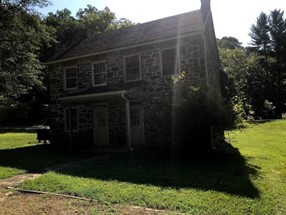 This building appears to have been built in the early 1800's, as a two family (duplex) house in the mill town of Avalon. Approximately 30 families lived in Avalon and the men and boys of these families were employed in the Avalon Iron and Nail Works. In 1822 the Ellicotts purchased and greatly expanded this iron producing factory. Prior to 1822, the site was known as the Dorsey Forge. Ironmaster Caleb Dorsey first built a forge and an iron furnace here in 1762 that used waterpower from a millrace that ran from the river near the present day Lost Lake. Here, workers pounded pig iron into nails, horseshoes, shovels and crow bars needed to clear land for growing tobacco. In May of 2000, this house was opened after extensive renovations as the park's first full-time History Visitor Center. After a pretty good run, the center closed in 2012 for renovations and remodeling.
Stop #2 The Waterworks
 In 1909, Victor C. Bloede, in an effort to improve community needs for a better and more reliable water supply, formed the Baltimore County Water and Electric Company. The Company built the Avalon Waterworks on the site of the abandoned Avalon Iron and Nail Works. The millrace was repaired to channel water from the river into a series of filters and settlement basins before pumping it to consumers in western Baltimore County and Baltimore City.
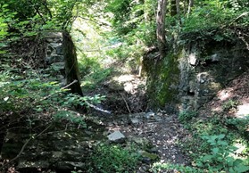
Stop #3 Gun Road over the Millrace
 The original "Gun Road” crossed this stone arched bridge. Opened in 1777, Gun Road was built to move cannons from Frederick to ElkRidge Landing during the Revolutionary War. At Elk Ridge Landing the cannons were loaded on ships bound for Yorktown, Virginia. The remains of the Avalon Millrace can be seen below this bridge.
Stop #4 Civilian Conservation Corps- Camp Tydings - Company 356 - CCC
(Open field in front of shelter 1 with fireplace)
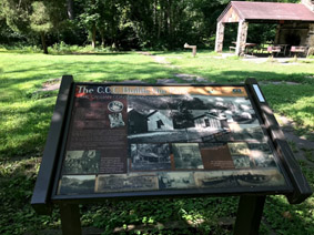 They called it "Roosevelt's Tree Army." During the Great Depression, the Civilian Conservation Corps was established by the federal government as one of many "New Deal" programs designed to stimulate the economy. Throughout the United States, the CCC put about 4 million unemployed young men, ages 18 to 25, to work improving public parks and forests. The CCC “Boys” lived in army-style camps like the one that was located here, between the river and the railroad. The CCC's planted millions of trees, fought forest fires, and built many of our Nation's finest national, state and local parks. Their projects were built to last like the cut stone pavilions and shelters throughout Patapsco Valley State Park. The stone fireplace in the shelter at the back of the CCC campsite that you see today once warmed the CCC camp's recreation hall.
Head back toward the Millrace to pick up the trail, or locate the alternative trailhead near shelter 1.
Stop #5 Avalon Millrace
 The trail through the woods, located between the old stone arched bridge and the river, parallels the Avalon Millrace that supplied waterpower first to the Dorsey Forge, then to the Avalon Iron and Nail Works and finally to the Water Works. Follow the Millrace Trail towards Lost Lake. As you cross a small footbridge, you will see the remains of the sluice gates which controlled the flow of water in the mill race. In the event of heavy rain or flood these wooden gates would be opened to send high water back to the river.
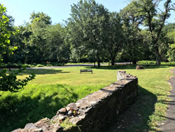
Stop #6 Lost Lake and the Avalon Dam
(This area was closed for visitor use after the floods of 2016 and 2018. Follow posted signs regarding visitor access to this area.)
The man-made pond is now called Lost Lake. It was totally destroyed in 1972 during Tropical Storm Agnes and then rebuilt as part of the park's redevelopment. Originally this pond was a reservoir for the iron industries and milltown village of Avalon.
Now walk to the split rail fence overlooking the Patapsco River behind Lost Lake. When you look across the river you will see the remains of the Avalon Dam on the opposite side. Depending on the time of year, this may take some searching because what remains of the dam stands in heavy tree cover. Prior to Tropical Storm Agnes (1972) this picturesque impoundment, provided a long scenic narrow recreational lake between Avalon and Orange Grove. A predecessor of this dam a short ways down river provided water power for the Dorsey Forge and the Avalon Iron and Nail Works. The original dam was destroyed in the Great Flood of 1868. In 1909, Victor Bloede's Baltimore County Water and Electric Company built this Avalon Dam just slightly upriver from the original dam.
Stop #7 Baltimore & Ohio Railroad Tunnel
In 1828 the Baltimore & Ohio Railroad began construction of the first commercial railroad in the United States. Its first thirteen miles ran from Mount Clare Station to Relay and then through the Patapsco Valley to Ellicott's Mills. Prior to the invention of the steam locomotive, horse-drawn enclosed rail cars carried passengers six and one half miles to Relay where they took a refreshment break while a fresh horse was harnessed to take the car through the scenic Patapsco River valley to the terminus at Ellicott's Mills. The B&O Railroad (RR) Directors knew that it was just a short matter of time until the steam locomotive would be perfected. With this powerful machine (the Iron Horse as some called it) it would be possible to ship goods, crops and natural resources back and forth from east and west and from north and south. The directors would seek the easiest of grades along river valleys in which to lay their rails, and they would build a substantial road bed with earthen fills and massive cut-stone bridges constructed to withstand floods and the tests of time. The tunnel before you is just one of thousands of railroad structures along the B&O RR right of way. It allows Soapstone Branch to flow uninterrupted to the Patapsco River and provides park visitors safe access to the scenic Glen Artney Area. Before the wide-spread popularity of the automobile, the residents of the valley's milltowns relied heavily on the railroad for transportation. It was then like taking the bus today. Little unmanned railroad stations displaying village names were popular visiting places while neighbors waited for the train that connected them with bright lights of Baltimore or a vacation in Western Maryland.
As you continue on your hike along the Grist Mill Trail towards Orange Grove, notice the large retaining walls and rock cuts above and below the railroad. Constructed in the late 1820's, most of these earthworks were developed by the hand-labor of immigrant workers (steel-driving men) who used hand chisels and hammers to build a railroad that would serve generations.
Stop #8 Tanker’s Remains, a reminder of the Floods of 1972
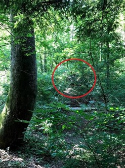 There had been sporadic showers for several days when on June 21, 1972, torrential rains from Tropical Storm Agnes fell in and around the Patapsco Valley. The huge volume of water that fell so rapidly could not be handled by normal drainage in the already swollen river. Disastrous flooding rapidly occurred. The river crested at some locations as much as 30 feet above normal levels taking out almost every object in its path. Patapsco Valley State Park from Ilchester to Elkridge looked like a war zone. Lands along the river were flattened and large sections of park roads were washed away. Large uprooted trees were scattered like a box of toothpicks accidentally dropped. Sections of the railroad bed were gone leaving the tracts and cross ties suspended in air. Portions of Bloede’s Dam and Avalon Dam were destroyed. The area was littered with damaged trucks and automobiles that were swept away from upstream. This portion of a tank truck was intentionally left behind by cleanup crews as a grim reminder of nature's power when it is out of control. During the 1970's, a massive state and federal effort supplemented by countless volunteers slowly put the park back together. In some ways the park is still recovering from Agnes and the storm of 1972.
Stop #9 Shifting Sediments and Siltation
Pause for a moment at the place where the stream crosses the Grist Mill Trail and falls over the edge to the River. This is a delightful spot to consider the dynamics of the river which is constantly changing. The moving of soil or silt downhill by water is a natural process but it is one conservation folks try to control. Siltation of a river impedes navigation of the waterway and creates unhealthy conditions for the fish life in the river. Thick forest cover on the valley's slopes is the best way to control erosion and siltation. The need to provide healthy forests along the Patapsco River is what got the Patapsco State Forest Reserve and the State Park started more than 93 years ago. The recreational benefits are just icing on the cake when you consider all the environmental benefits the State Park provides.
Stop #10 Orange Grove Mill
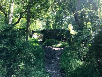 George Bayly and George Worthington developed the first grist mill at Orange Grove in 1856. Shortly before the start of the Civil War, The C.A. Gambrill Manufacturing Co. purchased the Orange Grove Mill in 1860 and transformed the picturesque mill into one of the largest flouring mills in the Mid-Atlantic States. If you look closely at the foundation ruins, you will see the outline of the Power House and the Superintendent's House to your left shortly before you get to the Swinging Bridge. In 1873 a steam engine was installed in the four story Power House. A large brick chimney stood beside the Power House. Look for the chimney's foundation among the ruins. It is directly across from the end of the Swinging Bridge on the Baltimore County side of the river. If you carefully climb the steep bank you can discover the "drop shoot" from the railroad where trains unloaded grains and coal.
To your right is the brick foundation of the Superintendent's House. This was the most luxurious house in Orange Grove. Rank had its privilege which included running water and a zinc bathtub.
Just a few steps upriver from the Swinging Bridge is the site of the mammoth six story Orange Grove Mill building that spanned the distance from the edge of the railroad to the edge of the Patapsco River. The mill covered the old Gun Road which passed through the Mill uninterrupted via a spacious tunnel. Just a very short distance upriver, a wooden dam in a crescent shape channeled water to the water wheel. The stone wall below, closest to the river, was part of the original mill race. Look across to the Howard County Side of the river to find one of the surviving Orange Grove dam abutments. A seven-story grain warehouse was connected to the mill on the upriver side opposite the dam abutment on the Baltimore County side of the river. It extended from the railroad to the road that ran under the mill. The warehouse was rectangular and constructed of larger stones that can be seen up hill in the remains of the stone wall. Some of these structures were damaged or destroyed during the 2016 and 2018 floods.
Stop #11 Bloede’s Dam Removal and Overlook
Continue down the Gristmill trail beyond the swinging bridge. Notice the remnants of flood damage from the 2016 and 2018 floods. You can still find debris from cars, railroad ties, and general litter from upstream. If you brought a trash bag feel free to pick up litter along the way and properly dispose of it at the end of your hike.
Bloede’s Dam was removed during the winter of 2018 and the final picture was taken in July 2019.
Stop #12 The Swinging Bridge
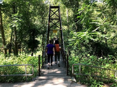 Now you are ready to cross the Swinging Bridge just like the mill workers would have done at the end of their day. Most of the mill workers lived in the Milltown of Orange Grove on the Howard County side of the River. The Swinging Bridge provided quick and easy access to and from the mill. Without the bridge it was a four mile commute to work.
Stop #13 The Village of Orange Grove
Seven houses and a combination church and school building comprised the Orange Grove Milltown that ran from the end of the Swinging Bridge to the upper end of the parking lot that is opposite the large cut-stone pavilion. All the houses but one were owned by the flour company. The one privately owned house belonged to the night foreman at the mill and it was located at the end of the Swinging Bridge where the park comfort station stands today. For many years prior to 1972, the night foreman's house was the Headquarters for Patapsco State park. Called the "Cascade Inn," it was rustic in appearance and looked the part of a park headquarters alongside the tumbling waters of the "Cascade Branch."
At the turn of the 20th century, children lived in Orange Grove. They had the river for their playground. Berry picking and hunting for chestnuts were popular pastimes. They watched the construction of the Ilchester Tunnel and the comings and goings of trains were a daily fascination. In winter, there were plenty of slopes for sledding and ice skating on the river. For special outings and vacations, their parents took them by train and trolley to the beaches of Bay Shore Park or by train to PEN MAR Park atop scenic South Mountain in Washington County. Living in Orange Grove provided a simple but uniquely special way of life. The journals of former residents give us a window to see some of that tranquil lifestyle along the river deep in the Patapsco canyon.
Stop #14 Cascade Trail
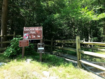 The Patapsco State Forest Reserve was created in 1907. Gradually forestry management began to restore the cut-over forest lands. The State Board of Forestry, beginning in 1912 to purchase additional lands for the Reserve and it took on, by agreement, the management of private property to expand their forestry efforts. Together, the improved forests and the recreation opportunities along the river, attracted many visitors to what people called a "Pleasure Ground." State Forester Fred W. Besley recognized the public enjoyment of the Reserve and designated portions of the Forest Reserve along the River as "Patapsco State Park.” Access was free of charge. Even campsites were free as long as you were careful with fire and abided by the rules.
In the 1920's, families set up camps for the entire summer. It was required that you must select a campsite with a spring and you must dig your own latrine. The Forest warden patrolling on horseback would stop by frequently to check the condition of your camp. The state park was a respectable place that attracted many YWCA camps, church camps, family groups and Boy Scouts. Some campsites were along the Cascade Trail. About a mile up the Cascade Trail, you will find a spring flowing out of a pipe. Here was one of the hundred popular campsites. In spring, this trail is bordered with a variety of native wildflowers and spring rains give new life to the Cascade Falls. The view before you speaks well for the reforestation efforts that started here over 93 years ago and continues to this day. The environment has reclaimed the Patapsco Valley and provided Marylanders this "Pleasure Ground" to enjoy for all time.
Return to the Swinging Bridge and continue back to the Offutt Johnson Visitor Center. Reflect on the impacts of dams on natural ecosystems and if the cons outweigh the pros. Think about how long human structures last and how different this area may look in another 100 years.
Conclusion
Thank you for your interest in studying the history and nature of the Patapsco Valley. We can assure you that this is only a glimpse into the rich history and heritage of the Patapsco Valley.
If you want further assistance in finding other parts of the Valley and Patapsco Valley State Park to explore, contact us at (410)461-5005.
Click here to return to the Activities Page.
Click here to return to the Patapsco Main Page.
