 Founded in 1907 as the Patapsco Forest Reserve, Patapsco Valley State Park is Maryland’s oldest state park. It is the site of some of Maryland’s earliest mills and factories, America’s first common-carrier railroad and the world’s first underwater hydroelectric plant.
Catastrophic floods and fires have damaged or destroyed many of the valley’s historic structures and sites. As you travel through the park, keep an eye out for historic structures, sites, and ruins. In some areas, wayside interpretive signs will help you discover the valley’s rich history, especially in the Avalon and Orange Grove Areas. Be sure to bring a park map with you on your journey.
Please note that on busy summer weekends, several park areas, including Avalon, Orange Grove, Hilton, Hollofield and Daniels, often fill to capacity. Be sure to arrive early if you plan to visit on weekends and summer holidays.
Historic Sites
There are four main areas of the park where trails, historic sites and parking lots are grouped together. Each area - Avalon, Orange Grove, Hollofield and Daniels - offers unique sites and experiences. The areas listed below follow a geographical sequence from downstream to upstream (southeast to northwest).
Elk Ridge Landing
Elk Ridge Landing, established in 1690, was a prominent colonial deep-water port, like Annapolis and Joppa. Prior to Baltimore’s establishment in 1729, Elk Ridge Landing was a "gateway" for shipping tobacco, grain, lumber and iron, and later cotton and flour. Thanks to erosion caused by deforestation, Elk Ridge Landing silted in and was no longer a serviceable port by 1868. Almost no evidence of the seaport is visible today.
Elkridge was the site of the Elk Ridge Furnace. Established by tobacco planter Caleb Dorsey in 1755, the furnace manufactured “pig iron”—cast iron that was worked into implements such as nails, horseshoes, and shovel spades by blacksmiths. The furnace reportedly supplied cannons and ammunition during the Revolutionary War. In the 1700s, the furnace’s primary workforce consisted of enslaved and convict labor.
You can view a portion of Elk Ridge Landing site at the historic Elkridge Furnace Inn restaurant (5745 Furnace Ave, Elkridge, MD 21075). The restaurant is within the state park and is leased as a private restaurant and conference center. This lease arrangement aids the state in preserving these historic buildings, while providing public access. The buildings in the Elkridge Furnace Inn restaurant complex date to the early-to-mid 1800s. Only scant ruins of the furnace itself remain along the riverbank.
Avalon Area
The Avalon Area includes the Thomas Viaduct and the William Offutt Johnson History Center, plus sites of the former Dorsey’s Forge/Avalon Iron and Nail Works, a water treatment plant, and Camp Tydings.
Completed by the Baltimore & Ohio (B&O) Railroad, the Thomas Viaduct is the world's largest multiple-arched stone railroad bridge on a curve. The viaduct is the first leg of the railroad’s Washington Branch. It is named for the B&O’s first president, Philip E. Thomas. The viaduct is located just west of the Avalon Area contact station. Enter the Avalon Area of Patapsco Valley State Park off U.S. 1 at South Street, just north of Elkridge. Proceed on Park Entrance Road to the contact station. Temporary parking is available in front of the contact station. An interpretive sign is located at the contact station. To view the bridge, carefully walk down the road to examine the Viaduct, keeping in mind the danger of the blind curve on the roadway. The viaduct can also be viewed from Levering Avenue on the Howard County (south) side of the river. Please note that the viaduct is still an active railroad. Do not, under any circumstances, approach the tracks or cross the bridge.
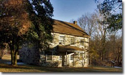
The William Offutt Johnson History Center (formerly the Avalon Visitor Center) is one of the few surviving buildings from Avalon Iron & Nail Works. Built in the 1830s, this tiny stone duplex was home to at least two families employed by the forge, which operated nearby from 1761 to 1868. Interpretive exhibit panels are located on the History Center’s grounds. Nearby are the remnants of the Baltimore County Water & Electric Company’s water treatment plant. Built in 1910, the water treatment plant supplied clean water to local communities into the 1930s. The History Center can be reached by following Park Entrance Road to the end, making a right at the “T” onto Gun Road and then parking in the parking lot on the right.
Old Gun Road stone arch bridge spanned the millrace that supplied water to the water treatment plant. The age of this bridge is unknown, but it was likely built in about 1910. The Gun Road stone arch bridge is located across from the History Center parking lot.
Near park Shelter #1 are the remains of Camp Tydings, a Civilian Conservation Corps (CCC) camp that operated between 1933 and 1942. The CCC was created in 1933 during the Great Depression. It employed young men between the ages of 18 and 25 to work on forest conservation projects, build park roads and trails, and construct several park shelters. During World War II, the CCC camp was converted to the nation's first conscientious objectors’ camp. The Shelter #1 chimney was built as part of the Camp Tydings Recreation Hall. Shelter #1 can be reached by following Park Entrance Road to the end, making a right at the “T” onto Gun Road and then the next immediate left. Two nearby shelters in Glen Artney, #66 in Upper Glen Artney and #10 in Lower Glen Artney, were built by the CCC.
Lost Lake is a man-made lake that once was part of the Avalon Dam and millrace. After Tropical Storm Agnes bypassed Avalon Dam in 1972 (part of it survives on the other side of the river), a new Lost Lake was built by DNR to replace the original. It is called Lost Lake because during much of the year an algae layer covers the pond.
At the end of Lost Lake parking lot is the eastern terminus of the Grist Mill Trail. Along the Grist Mill Trail between Avalon and Orange Grove are the remnants of a tanker truck that was deposited on the riverbank by Tropical Storm Agnes in 1972.
Orange Grove Area
The Orange Grove Area includes the swinging bridge, ruins of the Orange Grove flour mill, site of Patapsco’s first campsites, the remains of the Patterson Viaduct, and the former site of Bloede’s Dam.
The swinging bridge spans the Patapsco River at Orange Grove, 1.6 miles northwest of Avalon. To reach the swinging bridge, follow River Road west of shelters #104 and #105. The former Orange Grove company town was located on the Howard County (south) side of the river (where the parking lot and restroom are currently located), while the mill was located on the Baltimore County (north) side, between the Patapsco River and the B&O Railroad. The swinging bridge allowed town residents to reach the mill and small rail station across the river. Built in 1856, the Orange Grove mill was owned by C.A. Gambrill Manufacturing Company for most of its history. It manufactured "Patapsco Superlative Flour" until it burned on May 1, 1905. Cross the bridge to discover ruins of this large mill site that extended from the railroad tracks to the swinging bridge abutment. The current swinging bridge was built in the late 1970s.
During the 1910s and 1920s, primitive campsites lined both sides of the Cascade Trail. White Baltimore residents were permitted to reserve these sites for free during the summer months. Many families chose to live in the park all summer while commuting to work by train on a daily basis. Few traces of these camps remain today.
The site of Bloede Dam is located about a mile upstream from Orange Grove. It is believed to have been the world's first submerged electric-generating plant. Local businessman and philanthropist Victor G. Bloede and electrical engineer Otto Wonder developed this unique and experimental hydroelectric dam, which operated from 1907 until about 1930. The dam was removed in 2018 to restore passage for migratory fish. To see the dam site, follow the River Road (on foot or by bicycle) upriver beyond Orange Grove Shelter #106, or follow the Grist Mill Trail (across the river) upstream.
The Patterson Viaduct was built for the B&O Railroad in 1829. Named for railroad director William Patterson, the bridge spanned 375 feet with four arches. Three of its arches were swept away by a flood in 1866. An iron bridge was built in its place until the line was bypassed in 1903. Today, the remaining abutment and arch support the “cable-stay” bridge that makes up the western terminus of the Grist Mill Trail.
Hollofield Area
The Hollofield Area includes the former site of Union Dam, the Union Dam Tunnel and the U.S. 40 Bridge.
The first Union Dam was built in 1810 by the Union Manufacturing Company for a cotton mill, which was located in present-day Oella, over one mile downstream. The mile-long millrace was intended to power several mills, but only powered one. The original stone and wood dam was replaced by a concrete dam in the early 1900s. Tropical Storm Agnes diverted the river around the dam in 1972. When the concrete dam was removed in 2010, remnants of the original dam were revealed. Today, you can visit the dam site by following the Union Dam Trail beyond Hollofield Shelter #300 down into the valley.
The nearby Union Dam Tunnel was built by the B&O Railroad in 1902 to bypass a tight, narrow curve around the hillside. A hiking trail follows the original railroad alignment around the hillside. The tunnel is on private property and is still an active railroad. Please view the tunnel from a safe distance and do not approach the tracks.
The U.S. 40 Bridge, originally called the Edmondson Avenue Extension Bridge, was built by the State Roads Commission in 1936 to carry Baltimore National Pike across the Patapsco Valley. Built of reinforced concrete, the bridge features 27 small arches overtop of a 180-foot-long gentle arch. Hollofield is named from the last owners of Ellicott’s Upper Mills, which was established in the late 18th century. A clerical error has caused the misspelling of “Hollifield” to stick and the park area today is called “Hollofield.”
Daniels Area
The Daniels Area includes the Daniels Dam, the ruins of the company towns of Daniels and Guilford and an abandoned alignment of the B&O Railroad.
The Daniels Dam once powered the mill and company town of Daniels. Originally called Elysville, then Alberton, Daniels was founded in 1829. During the Civil War, the cotton mill produced canvas tents for the Union. The current name, Daniels, came from C.R. Daniels, Inc., which took ownership of the mill and company town in 1940. C. R. Daniels demolished much of the company housing in 1968 and Tropical Storm Agnes destroyed the mill in 1972. To visit the Daniels Dam and town site in Howard County, take Route 29 north to its termination at MD Route 99 (Old Frederick Road/Rogers Avenue). Turn right on Rogers Avenue and proceed to the traffic circle. Take the third exit onto Old Frederick Road. Proceed about one-half mile to a left on Daniels Road. Then drive about one mile to a parking lot on the left and the dam will be on your left. Please note that the site of the original mill, along with the surviving James A. Gary Methodist Church, are on private property. Do not trespass.
Much of the Old Main Line Trail west of Daniels on the Howard County site follows the original alignment of the B&O Railroad as it was laid out in 1831. It was found to be too windy, even in the 1830s, and part of this line was bypassed by a short realignment in 1838, and then completely bypassed in 1907. Bridge abutments and piers from the 1838 realignment are visible near Daniels Dam and about a half-mile upstream.
Guilford was built as part of the Alberton/Daniels company town, but because it was built on the other side of the river, it had its own identity. To reach Alberton Road, follow the directions to Daniels Dam, but instead of making a left on Daniels Road, continue to follow Old Frederick Road. After crossing the steel bridge, continue on Hollofield Road. Proceed .3 miles to a “T” intersection with Dogwood Road. Turn left over a bridge, then turn left immediately onto Alberton Road. Park in the lot before the cattle gate. Proceed through the gate by foot or bicycle passed the private home on the hill. Hike Alberton Road behind the gate and along the river. Please use caution when exploring the ruins.
For Further Reading…
Cramm, Joetta M., A Pictorial History of Howard County, Donning Publishing, 1988.
Dilts, James W., The Great Road: The Building of the Baltimore and Ohio, the Nation’s First Railroad, 1828-1853, Stanford University Press, 1996.
Harwood, Herber H., Impossible Challenge II: Baltimore to Washington and Harpers Ferry, 1828-1994, Barnard Roberts, Inc., 1994.
McMillion, Betsy A. and Edward F. Johnson, Patapsco Valley State Park, Arcadia Publishing, 2019.
Sharp, Henry K., The Patapsco Valley, Cradle of the Industrial Revolution in Maryland, The Maryland Historical Society, 2000.
Travers, Paul J., The Patapsco: Baltimore’s River of History, Schiffer Publishing, 2016.
