Hereford Area Trails and Trail Map
Hikers and horseback riders are welcome to enjoy over 20 miles of scenic, rocky, and occasionally steep trails in the Hereford area. Please stay on designated trails; this area is designated by the Maryland General Assembly as a State Wildlands for its unique wilderness character and ecological value. Bicycles are strictly prohibited.
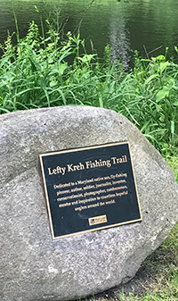 Lefty Kreh Fishing Trail
Formerly known as the Gunpowder South Trail, the
Lefty Kreh Fishing Trail runs along the Big Gunpowder Falls in an area that stretches from Prettyboy Reservoir to Big Falls Road.
Named after avid Maryland conservationist Bernard Victor “Lefty” Kreh, Kreh used every available means to promote conservation, clean water and giving back to the outdoors. Kreh’s works spearheaded the expansion of saltwater fly fishing across the country and then the world.
In 1974, he completed the seminal book on the sport—Fly Fishing in Saltwaters. He is also known for the Lefty’s Deceiver, a uniquely practical fly pattern he designed to fool striped bass—Maryland’s State fish—into biting an angler’s line. The bucktail fly pattern is the most widely used and imitated saltwater fly in the world.
Trail Map
A map of the trails at Gunpowder Falls State Park's Hereford Area can be downloaded for free from this website. Please make sure to read the printing instructions and information for how to download the file to cell phones. The map is in a PDF format that requires Adobe Reader.
To get the free Adobe Reader go to Adobe.com.
