The printed version of the Code of Maryland Regulations (COMAR) is the official and enforceable text. Only the official text may be judicially noticed under Courts and Judicial Proceedings, Section 10-203, Annotated Code of Maryland. For the complete, searchable, text of these regulations to access the Maryland Division of State Documents.
08.02.01.06 - Code of Maryland Regulation
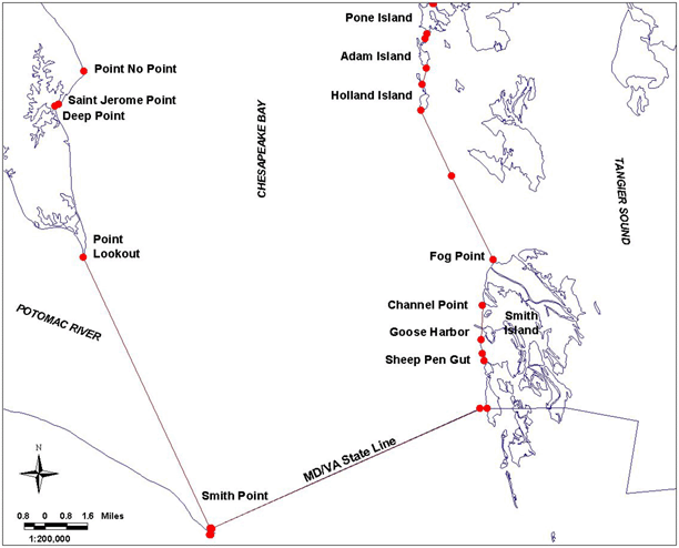
Bay Definition, Map No. 1
.06 Dividing Lines of the Chesapeake Bay, Sounds and Straits.
A. The boundaries set forth in §B of this regulation are designated as official dividing lines of the Chesapeake Bay, sounds and straits.
B. Any creek, cove, or other tributary less than 100 yards in width that intersects any segment of the following delineating lines shall not be a part of the described area.
(1a) Chesapeake Bay, Western Shore. - Description reads south to north.
All of the waters of the State enclosed by a line beginning at a point at or near Maryland/Virginia Boundary Point 1, south of Smith Point, defined by Lat. 37°53.19' N and Long. 76°14.20' W; then running approximately 286° True to a point at or near the mean low water line of the shore, defined by Lat. 37°53.20' N and Long. 76°14.24' W; then running northerly along the mean low water line to a point at or near the south side of the south jetty at Smith Point, defined by Lat. 37°53.36' N and Long. 76°14.19' W; then running northeasterly along the mean low water line on the south side of the south jetty to a point at or near the east end of the south jetty, defined by Lat. 37°53.38' N and Long. 76°14.14' W; then running approximately 324° True to a point at or near the east end of the north jetty, defined by Lat. 37°53.41' N and Long. 76°14.17' W; then running southwesterly along the mean low water line on the north side of the north jetty to a point at or near the mean low water line of the shore, defined by Lat. 37°53.40' N and Long. 76°14.22' W; then running approximately 335° True to a point at or near Point Lookout, defined by Lat. 38°02.25' N and Long. 76°19.34' W; then running northerly along the shore to a point at or near Deep Point, defined by Lat. 38°07.16' N and Long. 76°20.47' W; then running approximately 71° True to a point at or near Saint Jerome Point, defined by Lat. 38°07.21' N and Long. 76°20.30' W; then running northerly along the shore to a point at or near Point No Point, defined by Lat. 38°08.28' N and Long. 76°19.25' W; then running northwesterly along the shore...
Continued north on bay Map #2....
(1b)Chesapeake Bay, Eastern Shore. - Description reads north to south
...then running southerly along the west shore of Pone Island to a point at or near the south end of Pone Island, defined by Lat. 38°09.40' N and Long. 76°05.13' W; then running approximately 203° True to a point at or near the north end of Adam Island, defined by Lat. 38°09.25' N and Long. 76°05.20' W; then running along the west shore of Adam Island to a point at or near the south end of Adam Island, defined by Lat. 38°08.29' N and Long. 76°05.16' W; then running approximately 197° True to a point at or near the north end of Holland Island, defined by Lat. 38°07.76' N and Long. 76°05.36' W; then running southerly along the west side of Holland Island to a point at or near the south end of Holland Island, defined by Lat. 38°06.91' N and Long. 76°05.41' W; then running approximately 156° True to a point at or near the Dorchester/Somerset County line, defined by Lat. 38°04.78' N and Long. 76°04.18' W; then running approximately 154° True to a point at or near Fog Point, defined by Lat. 38°02.04' N and Long. 76°02.50' W; then running southerly along the west shore of Smith Island to a point at or near Channel Point, defined by Lat. 38°00.57' N and Long. 76°02.96' W; then running approximately 183° True to a point at or near the south entrance of Goose Harbor, defined by Lat. 37°59.45' N and Long. 76°03.04' W; then running southerly along the west shore of Smith Island to a point at or near the north side of Sheep Pen Gut, defined by Lat. 37°58.99' N and Long. 76°02.98' W; then running approximately 169° True to a point at or near the south side of Sheep Pen Gut, defined by Lat. 37°58.77' N and Long. 76°02.93' W; then running southerly along the west shore of Smith Island to a point at or near the intersection of the shoreline and the Maryland/Virginia state line, defined by Lat. 37°57.21' N and Long. 76°02.82' W; then running approximately 270° True to a point at or near Maryland/Virginia boundary point Sassafrass Hammock, defined by Lat. 37°57.21' N and Long. 76°03.12' W; then running approximately 245° True to the point of beginning, defined by Lat. 37°53.19' N and Long. 76°14.20' W.
