Eastern Bay Region Project
Eastern Bay, Cox Creek, Prospect Bay Complex (Cabin Creek, Prospect Bay, Mill Hill), Wye River and Miles River sanctuaries
The Eastern Bay region is located in the mid-Bay region of the Maryland waters of the Chesapeake Bay. It includes seven oyster sanctuaries, nine active aquaculture leases (September 2025) and 32 harvest areas designated as Public Shellfishery Area (PSFA). The region has 15,664 acres of sanctuary bottom, 27,134 acres of harvest bottom, with 56.1 acres of leases. It is divided into three NOAA Code harvest areas (039- Eastern Bay, 060- Miles River and 099- Wye River). The Eastern Bay region has 77 historic named Yates Bars of which approximately 42 are sampled on the DNR Fall Oyster Survey.
The Eastern Bay Region is a historically important region for oyster management in Maryland. For decades it contained an important seed area during the seed and shell program. It received tens of millions of bushels of shell plantings to improve habitat throughout the decades, and it was a top producing harvest area for numerous seasons with hand tonging as the dominant harvest gear. In 1997, it had a record spatfall, however, shortly after, disease hit the region and devastated the oyster population, which has since struggled to recover. Large areas of the Eastern Bay region are limited to diving and hand tong only for harvest. There are 2 relatively small areas open to power dredging.
The department identified the Eastern Bay region as a priority area for oyster restoration and initiated the Eastern Bay Project in 2019 toward this goal. A major concept was to include all three oyster sectors (sanctuary/fishery/aquaculture) and build relationships toward a common restoration goal. The Oyster Advisory Commission (OAC) was briefed by the department and the OAC endorsed the project’s dual approach: restoration of oysters and restoration of relationships. Legislation passed by the General Assembly in 2019 tasked the Oyster Advisory Commission (OAC) with developing a set of consensus management actions for enhancing and implementing the fisheries management plan for oysters and to achieve the targets identified in the oyster stock assessment with the goal of increasing oyster abundance. The OAC was also charged with developing a package of consensus recommendations through a facilitated consensus solutions process based on a 75% majority agreement level for each recommendation. One of the consensus recommendations was in support of the department’s Eastern Bay Region Project but expanding it to a much longer timeframe with enhanced funding. Their recommendation was:
Over the next 25 years, a combination of replenishment, restoration and aquaculture activities should be collectively planned and undertaken in Eastern Bay, with an equal amount of funding for spat planting in sanctuaries ($1M annually adjusted for inflation) and for spat and shell planting on fishery bars ($1M annually adjusted for inflation) in addition to current replenishment and restoration activities. The effectiveness of this option should be evaluated every 5 years.
Another consensus recommendation was in support of the department’s ongoing approach of including all three oyster sectors:
Improve organization and cooperation among groups and integrate projects across the 3 sectors (fishery, aquaculture, restoration).
The Eastern Bay Region Project has the full support of the department, the OAC, many oyster partners and the Legislature. It is an example where all three sectors can work together.
This website will be updated as the plans for action are developed.
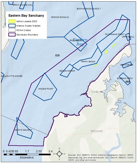
Eastern Bay
The Eastern Bay Sanctuary is located along the southern shore of Eastern Bay, a medium salinity (Zone 2) region with an average salinity between 12 and 14 ppt and lies within NOAA Codes 027 and 039. The sanctuary was created in 2010 and encompasses 4,521 acres of which 939 acres (21%) are historic oyster bottom (as charted in the Yates Oyster Survey from 1906 to 1912 plus its amendments). There are 7 historic oyster bars that have a portion of their area within the sanctuary. Eastern Bay sanctuary received a restoration planting in 2020 of 16 million hatchery spat-on-shell.
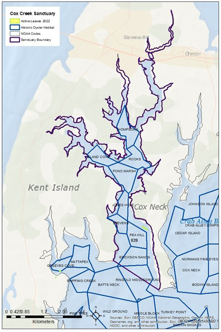
Cox Creek
The Cox Creek Sanctuary is located in a tributary of Eastern Bay, a low salinity (Zone 1) region with an average salinity between 5 and 11 ppt and lies within NOAA Code 039. The sanctuary was created in 2010 and encompasses 2,112 acres of which 939 acres (45%) are historic oyster bottom (as charted in the Yates Oyster Survey from 1906 to 1912 plus its amendments). There are nine historic oyster bars within the sanctuary, one of which (Ringold Middleground) is located only partially within the sanctuary. No replenishment or restoration plantings have occurred since 2006 with the exception of Marylanders Grow Oysters. Marylanders Grow Oysters plantings occurred between 2011 and 2015 on Jones Hole oyster bar. So far since the start of the Eastern Bay project (2023-2025), DNR has planted 100.2M spat-on-shell on Ringold Middleground, 6.9M spat-on-shell on Pea Hill, and 18.4M spat-on-shell on Erickson Sands.
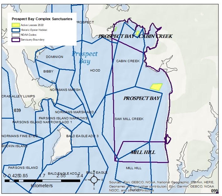
Prospect Bay Complex- Cabin Creek, Prospect Bay and Mill Hill
Prospect Bay- Cabin Creek
The Prospect Bay Cabin Creek Sanctuary is located in Eastern Bay, a low salinity (Zone 1) region with an average salinity between 5 and 11 ppt and lies within NOAA Code 039. The sanctuary was created in 2005 for restoration work by the Chesapeake Bay Environmental Center, which was designated by the state as a site for testing and developing comprehensive restoration techniques that might have bay-wide application for enhancing oyster stocks. The sanctuary encompasses 298 acres of which 128 (43%) is historic oyster bottom (as charted in the Yates Oyster Survey from 1906 to 1912 plus its amendments). There is one historic oyster bar (Cabin Creek bar) within the sanctuary. The sanctuary received restoration plantings between 2006 and 2012 where 6.5 million hatchery spat-on-shell were planted and 160 reef balls were deployed.
Prospect Bay
The Prospect Bay Sanctuary is located in Eastern Bay, a medium salinity (Zone 2) region with an average salinity between 12 and 14 ppt and lies within NOAA Code 039. The sanctuary was created in 2010 and encompasses 1,478 acres of which 1,061 (72%) is historic oyster bottom (as charted in the Yates Oyster Survey from 1906 to 1912 plus its amendments). There are 3 historic oyster bars within the sanctuary. The area has received one restoration planting in 2011 where eight million hatchery spat-on-shell were planted on 21 acres. So far since the start of the Eastern Bay project (2023-2025), DNR has planted 133.85M spat-on-shell on Saw Mill Creek.
Mill Hill
The Mill Hill Sanctuary is located in Eastern Bay, a medium salinity (Zone 2) region with an average salinity between 12 and 14 ppt and lies within NOAA Code 039. The sanctuary was created in 2000 for a US Environmental Protection Agency (EPA) project examining mounded habitat and alternative materials for oysters. The sanctuary encompasses 295 acres of which 188 (64%) is historic oyster bottom (as charted in the Yates Oyster Survey from 1906 to 1912 plus its amendments). There are 2 historic oyster bars within the sanctuary although neither bar has the majority of its area within the sanctuary (Mill Hill 31% and Saw Mill Creek 9%). From 2006 to 2020, approximately 82 million hatchery spat-on-shell were planted for restoration purposes. In 2021, The Nature Conservancy planted approximately 237,113 aquaculture oysters in this sanctuary of which 61% were diploid as part of a nationwide program to help aquaculture farmers impacted by Covid19. So far since the start of the Eastern Bay project (2023-2025), DNR has planted 42.5M spat-on-shell on Saw Mill Creek and 95.2M spat-on-shell on Mill Hill.
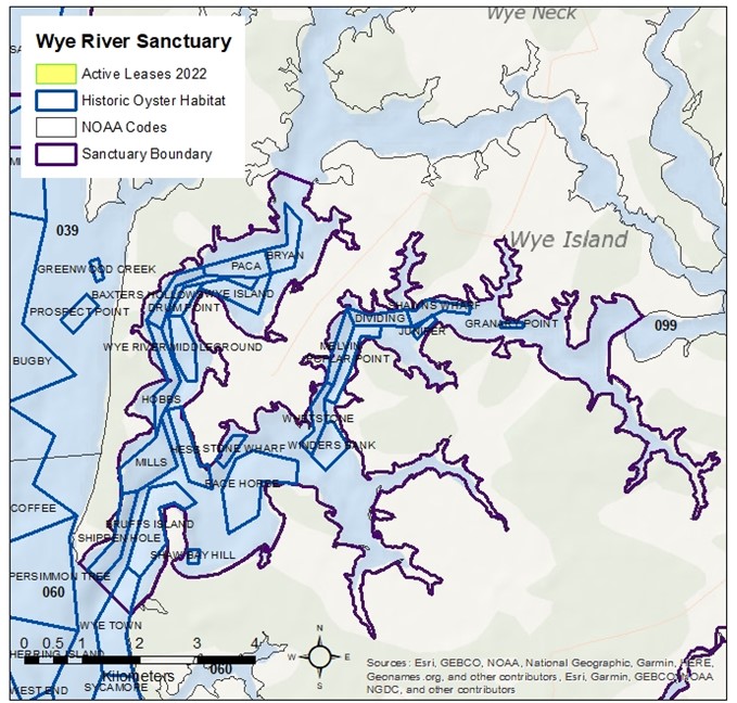
Wye River
The Wye River Sanctuary is located in Eastern Bay, a medium salinity (Zone 2) region with an average salinity between 12 and 14 ppt and lies within NOAA Code 099. The sanctuary was created in 2010 and encompasses 3,510 acres of which 1,100 (31%) is historic oyster bottom (as charted in the Yates Oyster Survey from 1906 to 1912 plus its amendments). There are 23 historic oyster bars within the sanctuary. Marylanders Grow Oysters, a public outreach program, has planted oysters annually in the sanctuary since 2010 on Wye River Middleground. So far since the start of the Eastern Bay project (2023-2025), DNR has planted 43.9M spat-on-shell on Bruffs Island, 66.7M spat-on-shell on Shippen Hole / Mills, 16.9M spat-on-shell on Wye Town and 8.4M spat-on-shell on Mills.
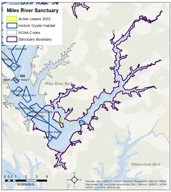
Miles River
The Miles River Sanctuary is located in the upstream section of the Miles River, a tributary of Eastern Bay that lies within NOAA Code 060. The sanctuary is in a medium salinity (Zone 2) region with an average salinity between 12 and 14 ppt. The sanctuary was created in 2010 and encompasses 3,449 acres of which 373 (11%) is historic oyster bottom (as charted in the Yates Oyster Survey from 1906 to 1912 plus its amendments). There are 5 historic oyster bars within the sanctuary. After the sanctuary was established, approximately 12 million hatchery spat-on-shell were planted for restoration purposes. Marylanders Grow Oysters have planted annually in the Miles River since 2010 on Long Point oyster bar. So far since the start of the Eastern Bay project (2023-2025), DNR has planted 36.7M spat-on-shell on an area adjacent to Bazzles Hill, 27.5M spat-on-shell on Bazzles Hill / Gibson Flats, 18.5M spat-on-shell on Long Point and 54.5M spat-on-shell on Gibson Flats.