The printed version of the Code of Maryland Regulations (COMAR) is the official and enforceable text. Only the official text may be judicially noticed under Courts and Judicial Proceedings, Section 10-203, Annotated Code of Maryland. For the complete, searchable, text of these regulations access the Maryland Division of State Documents.
08.02.01.06 - Code of Maryland Regulation
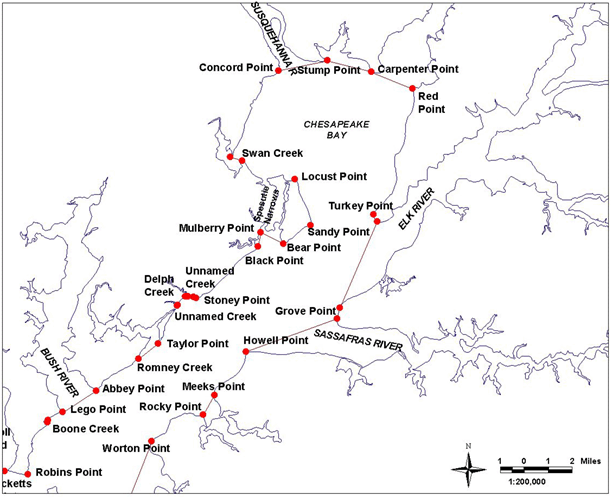
Bay Definition, Map No. 7
.06 Dividing Lines of the Chesapeake Bay, Sounds and Straits.
A. The boundaries set forth in §B of this regulation are designated as official dividing lines of the Chesapeake Bay, sounds and straits.
B. Any creek, cove, or other tributary less than 100 yards in width that intersects any segment of the following delineating lines shall not be a part of the described area.
(1) Chesapeake Bay. - Description splits between Western and Eastern Shore as you move south to the other maps.
...then running northeasterly along shore to a point at or near Black Point, defined by Lat. 39°26.11' N and Long. 76°06.11' W; then running approximately 11° True to a point at or near Mulberry Point, defined by Lat. 39°26.62' N and Long. 76°05.98' W; then running approximately 117° True to a point at or near Bear Point, defined by Lat. 39°26.20' N and Long. 76°04.93' W; then running northeasterly along the east shore of Spesutie Island to a point at or near Sandy Point, defined by Lat. 39°26.87' N and Long. 76°03.65' W; then running northerly along the east shore of Spesutie Island to a point at or near Locust Point, defined by Lat. 39°28.52' N and Long. 76°04.38' W; then running westerly along the north shore of Spesutie Island and the road causeway across Spesutie Narrows to a point at or near the southernmost point at the entrance of Swan Creek, defined by Lat. 39°29.22' N and Long. 76°06.82' W; then running approximately 289° True to a point at or near the northerly point at the entrance of Swan Creek, defined by Lat. 39°29.36' N and Long. 76°07.36' W; then running northerly along shore to a point at or near Concord Point, defined by Lat. 39°32.44' N and Long. 76°05.09' W; then running approximately 79° True to a point at or near Stump Point, defined by Lat. 39°32.79' N and Long. 76°02.80' W; then running approximately 105° True to a point at or near Carpenter Point, defined by Lat. 39°32.37' N and Long. 76°00.75' W; then running approximately 112° True to a point at or near Red Point defined by Lat. 39°31.75' N and Long. 75°58.84' W; then running southerly along the west shore of Turkey Point Neck to a point at or near Turkey Point, defined by Lat. 39°26.97' N and Long. 76°00.56' W; then running approximately 204° True to a point at or near the north side of Grove Point, defined by Lat. 39°23.87' N and Long. 76°02.34' W;...
Continued south on bay Map #6
