The
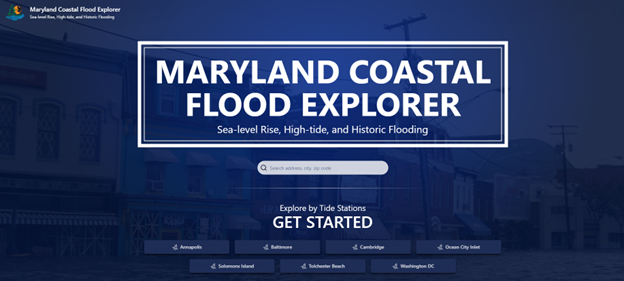
Maryland Coastal Flood Explorer is a valuable tool for visualizing predicted flood levels in Maryland’s coastal zone. This explorer presents higher resolution predicted, historic and current flood depths created from locally collected LiDAR-derived elevation data. The application was created through a partnership with the
National Oceanic and Atmospheric Administration (NOAA),
University of Maryland Sea Grant Extension (UMD SGE),
University of Maryland College Park (UMD), and Salisbury University's
Eastern Shore Regional GIS Cooperative (ESRGC). The tool visualizes Maryland specific sea level rise projections that are determined every five years by a team of experts through
University of Maryland Center for Environmental Science (UMCES) last released in 2023. More information on flood modeling can be found within the information tab  of the tool.
The goal of developing this tool is to help coastal decision makers at the state and local level understand current conditions and future vulnerability to flooding and serve as a basis for short, mid, and long term planning.
Below are resources developed to help users understand the basics of the tools and potential use cases.
Video TutorialHow to ManualHelpful Layers
Case studies are provided below, with a brief description and a link to a PDF download for each specific study.
A small waterfront municipality on Maryland’s Eastern Shore is working on its Nuisance Flood Plan. They decide to use the MD Flood Explorer to identify their vulnerable community resources and critical infrastructure and identify which communities they should target for flood mitigation projects and outreach campaigns.
Link to case study here.
A land trust learns that a property owner is considering putting their property into a conservation easement. The land trust wants to review the sea level rise impacts as a way to anticipate how the land cover may change to inform management strategies and determine if the property will provide other environmental benefits over the long term.
Link to case study here.
A Community Flooding Extension Specialist in Worcester County received a call from a seasonal resident living in an unincorporated area of the county. The resident, representing a small group of lot owners, expressed concerns about flooding in their RV park and mobile home community following a recent storm and requested assistance.
Link to case study here.
An environmental center on a peninsula experiences flooding of their only access road at high tide, a condition projected to worsen due to sea level rise. They’ve developed a project to elevate the degraded marsh along the road thus restoring the marsh and protecting the road. They are putting together a grant application and want to use the MD Flood Explorer to demonstrate the current and future need for this project. The project team plans to use the tool to visualize the risk and justify the need for adaptation measures in their grant applications.
Link to case study here.
A town located on the Eastern Shore and within the Critical Area with a highly developed waterfront wants to address current and predicted flooding along its tidal shoreline. The Town has a robust Critical Area fee-in-lieu program and has created an MOU with the Critical Area Commission (CAC) to identify the types of projects that may be implemented using FIL money. These include projects that address climate resiliency, enhance and/or protect habitat, improve water quality, increase public access to the water, and mitigate impacts to overburdened/underserved communities.
Read more about this case study here.
The current version of the Flood Explorer was released in July of 2025. We welcome your feedback and questions, to get in touch please email
[email protected].


This tool and associated resources were prepared using Federal funds under Maryland Coastal Zone Management award number NA22NOS4190019 from NOAA, U.S. Department of Commerce. The statements, findings, conclusions, and recommendations are those of the author(s) and do not necessarily reflect the views of NOAA or the U.S. Department of Commerce.
