Calvert Cliffs, Calvert County
Over 15 million years ago, a shallow sea covered much of Maryland. As the sea receded, it eventually left in its wake the layered sandy and clayey sediments found at Calvert Cliffs. The shells and bones of dead animals drifted to the bottom of the sea and were buried in the sediments. Waves and storms eroded the exposed sediments and formed steep cliffs that harbor the fossil remains of those ancient animals. The gradual erosion of the cliffs continues to produce the sandy beaches found along the shore. In addition to the majestic cliffs and sandy beach, Calvert Cliffs offers hiking trails through over 1,000 acres of old woods and wetlands.
 Steep sloped ravines are shady and cool in the summer heat. Together with the contiguous forest on adjacent protected lands and other properties, Calvert Cliffs lies within a nearly 4,000 acre block of forest that provides habitat for wildlife that are vulnerable along forest edges. Wood thrushes and barred owls are among the forest interior dwelling species that thrive here. American beavers and common muskrats are active in the wetlands, and herons and egrets wade the marshes. In early summer, yellow flowers of Endangered swollen bladderwort (Utricularia inflata) dot the water.
Calvert Cliffs Natural Area is managed as a State Park through the Maryland State Park Service. The Natural Area encompasses over 1,000 acres of wilderness which contains 13 miles of marked trails. Visitors can enjoy a variety of outdoor experiences at the park from hiking and biking to camping and wildlife watching.
 Prehistoric Fossils
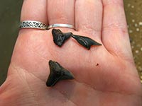
Fossils of over 600 species have been found along Calvert Cliffs. Casual visitors can comb the beaches in search of prehistoric shark teeth, skate teeth and remnants of creatures which inhabited the area millions of years ago.
You're in Tiger Beetle Country
While people hunt for fossils on a warm summer day, several species of tiger beetles hunt for prey on the open, sandy beaches at Calvert Cliffs. This large, colorful group of beetles is known for speed and aggressive hunting of their invertebrate prey. Patient visitors may catch a glimpse of the two tiger beetles federally listed as Threatened and State listed as Endangered, the Puritan tiger beetle (Cicindela puritana) and the northeastern beach tiger beetle (Cicindela dorsalis dorsalis). Both the eroding cliff face and the sandy beach provide vital habitat to these species, and their decline in Calvert County suggests the habitats are degrading.
 Click here for a Print Version of this map.
Calvert Cliffs Natural Area
Special Note: Calvert Cliffs Natural Area is used seasonally by hunters.
Due to the danger of the landslides caused by cliff erosion and the serious injuries they can cause, climbing upon and walking beneath the cliffs is prohibited. Thank you for your safe cooperation.
Directions
From Washington, DC: Travel I-95/495 (Capital Beltway) to Exit 11 and head south on MD 4 into Calvert County. After about 30 miles (from the Beltway), continue past Prince Frederick another 12 miles to MD 765 (HG Trueman Road). Turn left (east) and follow the signs leading to the entrance to the State Park, in about 1.4 miles.
Driving directions and aerial views open with Google Maps. For the aerial view button, if an aerial view does not open by default, click on the Satellite icon in the upper right corner and Google Maps will switch to an aerial view of the Natural Area.
