Fishing Bay Marshes, Dorchester County
Affectionately known as the "Everglades of Maryland", the tidal wetlands of lower Dorchester County are some of our largest and most intact natural systems. In the heart of this system is the Fishing Bay Natural Area which is a mosaic of brackish marshes and wooded swamps. The expansive wetland system is home to many marshbirds including the secretive, Endangered Black Rail (Laterallus jamaicensis). A nine-mile road provides access through the marshes, and adventurers can continue their explorations on designated water trails in canoes, kayaks or other small watercraft. Visitors can also enjoy excellent opportunities for saltwater fishing or crabbing within the wetland.
Of critical importance to the wetland system are the "high marsh" areas that are only occasionally flooded by extreme high tides or storm surges. This habitat is formed of salt marsh hay and sea-shore saltgrass which provide important habitat for ground-nesting birds like Northern Harriers, Willets and Saltmarsh Sparrows. Only a decade ago, these vast marshes were in danger of being ruined by nutria, a water rat introduced from South America. Thanks to extensive trapping by the Chesapeake Nutria Partnership, the rodents are absent today and the marsh is thriving. The Fishing Bay Natural Area is mostly contained within the Fishing Bay Wildlife Management Area managed by the Maryland Department of Natural Resources.
Calling All Birders
Fishing Bay is a haven for birders. Its many habitats, ranging from forests to expansive marshes allow for a variety of birds to make their home within the Natural Area. Notable species include rare marshbirds such as the American Bittern (Botaurus lentiginosus), Least Bittern (Ixobrychus exilis), Sora (Porzana carolina), and Common Gallinule (Gallinula galeata). Other rare species like the Coastal Plain Swamp Sparrow (Melospiza georgiana) and Sedge Wren (Cistothorus platensis) can also be seen here.
 Water On The Rise
A combination of sea-level rise and land subduction are causing some marshes in Maryland to convert to open water. Because of this, Fishing Bay's undeveloped uplands are expected to take the place of these wetlands as water levels continue to increase over the next 100 years.
Click here for a Print Version of this map.
 Directions
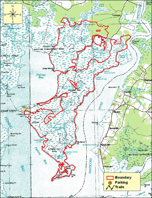
About nine miles south of the town of Vienna in eastern Dorchester County, the landscape transforms from agricultural fields and pine woods into a vast tidal marsh ecosystem. From US Route 50 east, take the Route 331 exit south to Vienna. Continue straight across Old Route 50 and turn left onto Race Street. Turn right on Market Street, which later becomes Elliott Island Road. Continue south until you reach the edge of the forest. There are three boat launch areas with small parking lots at each site. Otherwise, there are no established hiking trails or boardwalks, restroom facilities or paved parking areas.
Special Note: The Fishing Bay Wildlife Management Area is used seasonally by hunters (for waterfowl and deer) and trappers (primarily for muskrat), as well as by fishermen and crabbers, in addition to nature enthusiasts.
Fishing Bay Marshes is a large Natural Area with many access sites for parking, paddling and boating.


Driving directions and aerial views open with Google Maps. For the aerial view button, if an aerial view does not open by default, click on the Satellite icon in the upper right corner and Google Maps will switch to an aerial view of the Natural Area.

Acknowledgments
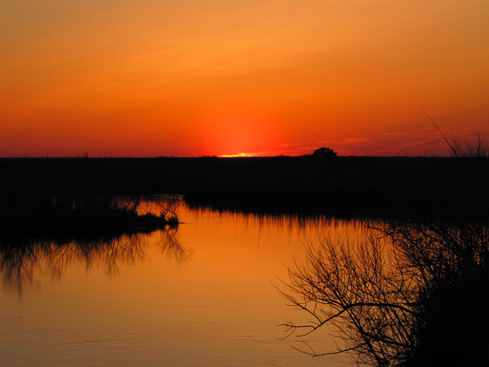
Scenic View of Fishing Bay Marshes. Photo by: Lynn Davidson
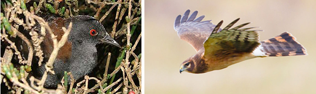
Wildlife Collage One: (left to right)
The elusive, sparrow-sized black rail stays very well hidden. Photo by: USGS/Wikimedia Commons
Northern harriers soar gracefully over the marshes as they hunt for small birds and rodents. Photo by: Wikimedia Commons
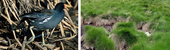
Wildlife Collage Two: (left to right)
Common gallinule are now rare but thrive at Fishing Bay. Photo by: Wikimedia Commons
Salt marsh hay blankets much of Fishing Bay's wetlands. These densely packed grasses serve as pollution filters and protect the Bay's shoreline from flooding and erosion. In addition, the grasses provide food, shelter, as well as hunting grounds for many animal and bird species. Photo by: Wikimedia Commons
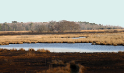
Some of Fishing Bay's marshes are slowly giving way to�open water. Photo by: George Schenck
