Recreation – Trails
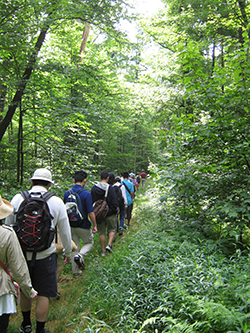
More than 55,000 acres of rugged terrain challenges hikers, hunters, anglers and mountain bike riders alike on Savage River State Forest. There are trails for snowmobiling, ORV trail riding and even cross-country skiing. Some of the trails are multiple use trails depending on the season. Each season brings the forest to life with delightful sounds and colors, like bright while trillium on a sunny slope and the sounds of migrating warblers taking a brief rest. Hikers are asked to protect the forest’s natural and historic resources by following the Leave No Trace ethics. Hikers should plan their trip, travel and camp on durable surfaces, dispose of waste properly, leave what you find, respect wildlife and be considerate of other visitors. All of Maryland’s State Forests are trash free – so pack out what you bring in. Thanks for being good stewards of the outdoors.
Trail Maps:
Asa Durst Trail: This trail is accessed off the West Shale Road. The trail is 4.5 miles and is a
loop system. The trail is considered to be
moderate. The upland hardwood forests that have reclaimed former pastures and farmlands host stands of pine and spruce trees and valleys rimmed in rhododendron. Many visitors use this area for day hikes, backcountry snow shoeing and cross-country skiing.
Poplar Lick Trail: This forested road begins off New Germany Road and ends at the Savage River Road. It is approximately 6 miles long. This trail is considered to be
moderate. This is a hiking, biking and camping trail. It has numerous stream crossings with only a few bridges. Visitors along this trail will see beautiful rhododendron blooms and wildflowers as well as the memorial site for the B-52 boomer between Sites #154 and #155.
Monroe Run Trail: This is a designated
HIKING trail only. There is no mechanical propulsion permitted on this trail. The trail is approximately 4.6 miles long and is considered to be
moderate. The crumbling bridge abutments are the only remaining evidence that this scenic trail was formerly a connection road built by the Civilian Conservation Corps. Frequent stream crossings provide plenty of cool resting spots along the way. There is a parking area off the New Germany Road and the trail ends near Big Run State Park.
Margraff Trail: This trail system is located in the Accident area of Savage River State Forest. It is almost 10 miles in length, and provides
mountain biking trails of varied difficulty; beginner, intermediate, and advanced. There is also a 2 mile intermediate adaptive mountain biking loop. These trails can also be hiked. There are gravel roads within this system that provide additional biking and hiking miles. The gravel roads are also open to
snowmobiles and
horseback riding. There are 4 primitave campsites located within the system. The elevation is 2800 feet and visitors enjoy splendid views all year long.
Mt. Aetna Tract Trails: This trail system is located off I-68, Exit 29 near Savage River Lodge.There are approximately 7.6 miles of trails considered to be
moderate. Diverse loops offer opportunities for
birdwatching, mountain biking, and hiking. Heavy snowfalls supports snowshoeing and cross-country skiing. This area is also referred to as Savage River Lodge.
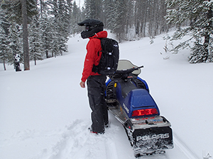
Meadow Mountain Trail: This trail runs along the ridgetop of the beautiful Meadow Mountain. It is approximately 12 miles long and considered to be moderate. This trail was originally created for fire control. The four mile section located near I-68 is open for ORV riding and licensed vehicle usage. The trail is closed December 15 – March 15 for snowmobile use only. Both snowmobiles and ORV’s must have a Maryland DNR Off-Road Permit to ride this trail. The permit is $10 a calendar year and the permit can be obtained online at the DNR COMPASS Site, at a Maryland DNR Licensing Office or at numerous state park/forest offices.
The remaining eight miles of the trail are closed to ORV’s, except for
snowmobiles. This part of the trail runs along the ridge top. This trail is used by hikers, bikers, backpackers and snowmobile riders. The last mile of the trail has a beautiful overlook that encases the gorgeous Monroe Run Valley and on a clear day, one can see Mt. Storm (West Virginia) and an occasional eagle. One can easily access the overlook area by taking New Germany Road south, to Frank Brenneman Road and traveling approximately one mile to the gated area. The hike is .9 mile one way.
Big Savage Hiking Trail: This trail is a designated
HIKING trail only. It is approximately 17 miles long and is considered to be
difficult. This trail is very popular due to the upland forests of oak and hickory, old pine farmsteads and rocky terrains blanketed by wild azalea and rhododendron. Remnants of an old fire tower still sit at an area called High Rock. Hikers need to bring plenty of water as there are limited reliable water sources along this trail. There is no motorized propulsion permitted on this trail. Please obtain a
backpack camping permit from the Savage River State Forest headquarters, kiosk, or print from the link to mail in advance.
Bowman Hill North Trails: This trail is located off I-68, Exit 19 traveling south approximately seven miles to Dung Hill Road. Dung Hill Road turns into Bowman Hill Road and the trail is a short distance. This trail is 8 miles long, is a loop trail and is considered to be
difficult. This uneven terrain and stream crossings make this very challenging for
mountain bikers and hikers. During the winter months,
snowmobiling is available on this trail system.
32 Mile Backpacker Loop: This backpacker loop incorporates the use of the Meadow Mountain Trail, the Monroe Run Trail, Savage River Road, Poplar Lick Trail and the trail system located in New Germany State Park. It is considered to be difficult. Primitive campsites are created as one hikes along the Meadow Mountain and Monroe Run Trails. Once the hiker gets on the Savage River Road, there are numbered campsites to utilize as well as numbered sites on the Poplar Lick Trail. The hike ends with hooking up to the New Germany State Park trails and coming out on McAndrews Hill Road and back to your vehicle. This is a popular hike. Please obtain a
backpack camping permit from the Savage River State Forest headquarters, kiosk, or print from the link to mail in advance.
 Off-Road Vehicle Trails
St. John’s Rock Off Road Vehicle Trail: This is the newest trail on Savage River State Forest. This is an area that has been designated as a
camping and off-road vehicle trail system. The trail system is approximately 13 miles and has varying challenges for riders of all skill levels. There are four large campsites and 4 small campsites. These campsites are available for reservations through the Maryland DNR COMPASS System. Prices vary according to the number of ORV’s. A Maryland Off-Road Vehicle permit is required for any ORV’s not licensed for the road by the MVA. The permit is $10 a calendar year and permits can be obtained online at the Maryland DNR COMPASS site, any Maryland DNR Licensing office, and numerous state forest/park offices. This system utilizes the Red Dog Road and St. John’s Rock Road and is open to hunters/sightseers/firewood cutters and of course, the ORV riders. Restrooms are available at this location. There is also a 200 foot rock crawl.
Meadow Mountain Trail: As described above, the 4 mile section of the trail located near I-68 and running to New Germany Road, is open to
ORV riding. There is no fee or reservations required. This trail is closed December 15 – March 15 for ORV riding. During the winter months, this portion of the trail as well as the remainder of the Meadow Mountain Trail are open for snowmobiling, as weather permits. Licensed vehicles can use this portion of the road as well.
The Code of Maryland Regulations (COMAR) 08.07.01.18 states an individual may not dig in search of buried relics or treasures, remove prehistoric or historic artifacts, or use metal detectors. Exceptions are granted for archeologists and other qualified individuals who present a plan for scientific investigation to be carried out under provisions of the Maryland Archeological Historic Properties Act and have a permit from the Maryland Historical Trust.
