 Maryland’s Coastal Resiliency Assessment is a landscape-level spatial analysis and modeling effort that identifies where natural habitats provide the greatest potential risk reduction for coastal communities. The Maryland Department of Natural Resources is taking steps to identify residential areas impacted by coastal hazards and rank shorelines where restoration and conservation efforts can provide coastal protection alongside habitat, water quality, and recreational benefits. Priority areas for restoration and conservation actions were identified based on the presence of existing habitat, its current role in risk-reduction along the shoreline, and the presence of nearby coastal neighborhoods.
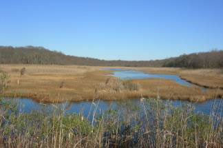
With its extensive shoreline, Maryland’s coasts experience flooding and erosion, caused by tides and storms and exacerbated by sea level rise. Natural habitats such as marshes and coastal forests can reduce the impacts of these hazards through the processes of wave attenuation, increased infiltration and sediment stabilization. By providing these benefits, coastal habitats represent natural adaptation solutions to better prepare communities for climate change.
We recognize that climate change will impact state facilities, investments, natural resources, and our low-lying rural and urban communities. Maryland’s Coastal Resiliency Assessment will help facilitate proactive solutions to enhance the resiliency of our coastal communities.
The Resiliency Assessment produced multiple data products that can be used in resiliency and adaptation planning:
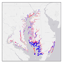
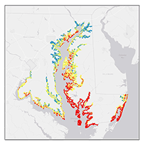 Shoreline Hazard Index
The Shoreline Hazard Index identifies high, moderate, and low hazard shorelines.
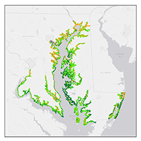
Habitat Role in Hazard Reduction
The Habitat Role in Hazard Reduction data identifies shorelines where habitats play a high, moderate, low, or nonexistent role in hazard reduction.
 Coastal Community Flood Risk Areas
The Coastal Community Flood Risk Areas rank residential areas from very low to very high risk based on probability of exposure to a flood event, population density, and social demographics (age, income, and language proficiency).
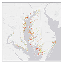
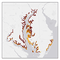 Priority Shoreline Area
The Priority Shoreline Areas identify Tier 1 and Tier 2 priorities for conservation and restoration actions. Tier 1 and Tier 2 shorelines represent areas where habitats have the potential to play a high or moderate role in risk reduction, respectively, for adjacent coastal communities.
 Marsh Protection Potential Index
The Marsh Protection Potential Index ranks the potential of existing marshes to protect coastal communities based on marsh size, proximity to hazards, proximity to residential areas, proximity to other coastal habitats, and the likelihood that the marsh will persist into the year 2100.
