Frederick County is comprised of two deer hunting zones that determine what firearms may be legally used to hunt deer. The zones were established at the request of Frederick County officials and in cooperation with the Maryland Farm Bureau.
The shotgun zone (Zone 2) prohibits the use of bottleneck cartridge, breech-loading rifles for deer hunting, limiting hunters to using shotguns, straight-walled cartridge rifles, handguns, muzzleloaders or archery equipment during the deer firearm seasons.
Hunters in Zone 1 may use bottleneck cartridge rifles and any weapons that are legal in Zone 2 during the designated firearms seasons. Please see the maps and boundary descriptions below.
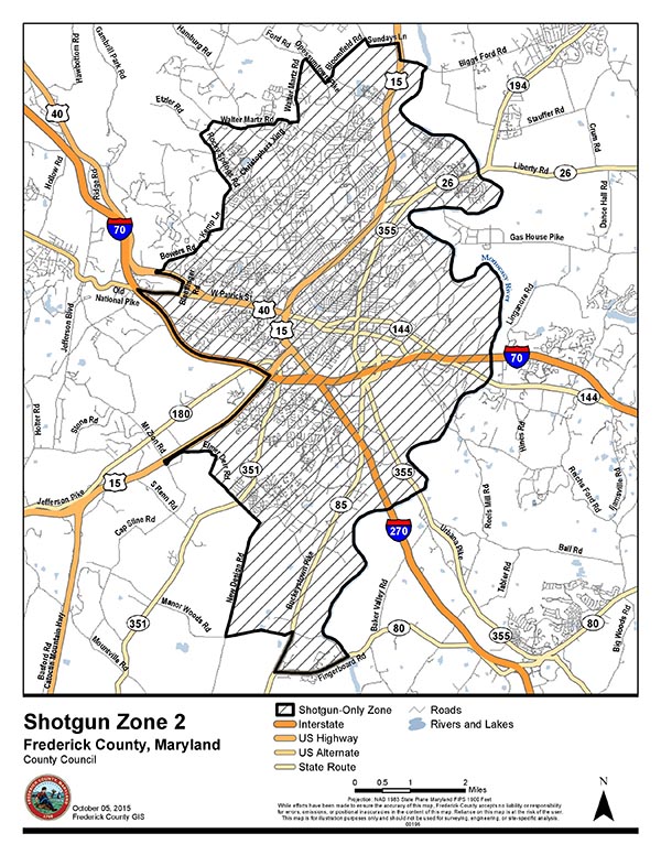
The east boundary of Frederick County Zone 2 is the Monocacy River beginning at Fingerboard Road and running north along the river to Biggs Ford Road. The north boundary is the south side of Biggs Ford Road beginning at the Monocacy River and running west to Route 15, then north on Route 15 to Sundays Lane, then west on Sundays Lane to Bloomfield Road, then southwest on Bloomfield Road to Opossumtown Pike, then northwest on Opossumtown Pike to Walter Martz Road, then south on Walter Martz Road to Christopher’s Crossing, then west on Christopher’s Crossing to Walter Martz Road, then west on Walter Martz Road to Rocky Springs Road, then west on Rocky Springs Road. The west boundary is Rocky Springs Road beginning at the intersection with Indian Springs Road, running south to Kemp Lane, then southwest on Kemp Lane to Shookstown Road, then southeast on Shookstown Road to Bowers Road, then southwest on Bowers Road to Patrick Street, then west on Patrick Street to Blentlinger Road, then south on Blentlinger Road to Old National Pike, then west on Old National Pike to Maryland Interstate 70, then southeast on Maryland Interstate 70 to Route 15, then southwest on Route 15 to Mt. Zion Road, then southeast on Mt. Zion Road to Elmer Derr Road, then southeast on Elmer Derr Road to New Design Road, then south on New Design Road to Manor Woods Road. The south boundary is Manor Woods Road, beginning at New Design Road, running east to Buckystown Pike, then southwest on Buckystown Pike to Fingerboard Road, and then east on Fingerboard Road to the Monocacy River.
Maps courtesy of the Frederick County County Council and GIS Department
