The Whole Watershed Program (WWP) was legislatively established through the Whole Watershed Act (SB 969/HB 1165) in April 2024. This new program was created to provide a highly collaborative, science-based approach to accelerate restoration of the Chesapeake Bay and Atlantic Coastal Bays and their watersheds.
The Whole Watershed Program is a five-year pilot program, targeting five watersheds with the goal of improving watershed health through a diverse selection of environmental actions. In direct response to the
Chesapeake Bay Program’s Comprehensive Evaluation of System Response (CESR) Report, multi-faceted program goals include: pollution reduction, habitat creation, aquatic resource improvements, equitable public access, carbon sequestration, public health enhancements, outreach to overburdened and underserved communities, and more.
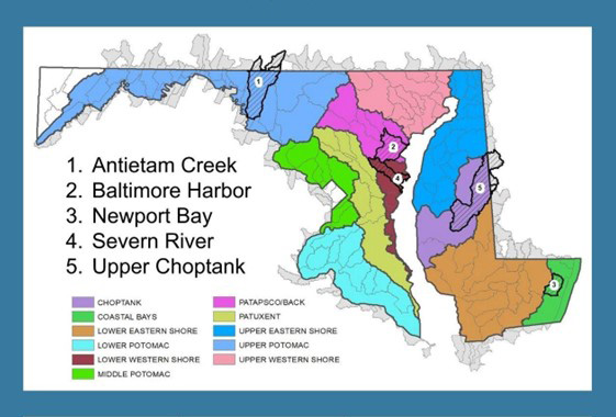
Selected Watersheds
A Request for Proposals (RFP) was issued October 1, 2024, and will be issued every 5 years following. The next RFP will be October 1, 2029. The State Management Team (SMT) may approve up to 5 projects to receive assistance by March 1, 2025 and every 5 years thereafter.
In March 2025, five watersheds were selected from nine applications throughout the State to participate in this five-year pilot Whole Watershed Program. The watersheds below illustrate a diverse representation of land uses, geographies, impairments, communities, partnerships and more.
The Whole Watershed Act requires the selection of watersheds meet the following designations: one urban, one suburban, two agricultural, one with an adjoining state, and two with opportunities to engage with overburdened or underserved communities.
See the selected watersheds, corresponding sectors and project sponsors below.
| Watershed | Project Sponsor | Sector
|
|---|
| Antietam Creek | Catoctin Land Trust | Agriculture, Env. Justice, Pennsylvania |
| Baltimore Harbor | South Baltimore Gateway | Urban, Env. Justice |
| Upper Choptank River | Shore Rivers | Agriculture, Env. Justice, Delaware |
| Newport Bay | Maryland Coastal Bays | Agriculture |
| Severn River | Resilience Authority | Suburban
|
FY27 Project Selections by Watershed
ANTIETAM CREEK ~ Catoctin Land Trust
| Project Name | Project Type | Project Description | Whole Watershed Funds | Outside Funding | Total Cost |
|---|
| Beaver Creek Stream Restoration Design | Stream Restoration Design | Stream Restoration Design from 30% to 90% and permitting | $254,271.4 | $188,800 | $413,800 |
| Doubs Mill Dam Removal & Stream Restoration Design | Stream Restoration Design | Stream Restoration Design from 30% to 90% and permitting | $119,218.67 | $0 | $0 |
| Antietam Watershed Afforestation Program (AWAP) | Tree Plantings ~ Implementation | 30 acres of Riparian and Upland Tree Planting, 5-year Maintenance, and 15 year landowner agreements | $236,229 | $248,500 | $369,400 |
| Antietam Water Trail Enhancements | Public Access ~ Implementation | Increased equitable access through new public park, personal watercraft access, parking, overlook, and more. | $216,257.25 | $325,000 | $525,000 |
| Agricultural - Education and Outreach | Education & Outreach | Outreach and education components of a larger initiative to increase upland agricultural practices in the Antietam watershed. Agricultural projects will be funded by MDA. | $20,000 | $0 | $20,000 |
| Antietam Conservation Easements | Land Conservation | Conservation easement on 271 Acres along Antietam Creek Mainstem across from Devil's Backbone. Funding may be used for additional easements. | $834,652.8 | $1,000,000 | $1,785,000 |
| Green Schools & Environmental Literacy | Environmental Literacy | Increase MD Green school participation within the Antietam Creek Watershed | $51,000 | $0 | $0 |
BALTIMORE HARBOR ~ South Baltimore Gateway Partnership
| Project Name | Project Type | Project Description | Whole Watershed Funds | Outside Funding | Total Cost |
|---|
| Baltimore Peninsula Shoreline Restoration Design | Coastal Restoration, Public Access - Design | Stabilization of up to 4,000 linear feet of shoreline, restoration of aquatic habitat, establishment of living shoreline, and public access improvements around Baltimore Peninsula with multiple landowners. | $1,384,347.82 | $0 | $1,384,347.82 |
| Westport Waterfront Park Phase I Construction | Public Access | Construct approximately 3 acres of a public park., maintained by SBGP, to celebrate the legacy of the Baltimore Black Sox. Benefits include: restoring public access to the waterfront, enhancing shoreline resiliency, and supporting Maryland’s Tree Solutions Now Act. | $357,826 | $2,000,000 | $2,357,826 |
| Reel Rewards Invasive Fish Species Bounty Program | Invasive Removal | Invasive species bounty program engaging and incentivizing local anglers to catch and remove invasive fish species from the Middle Branch. | $101,304.35 | $0
| $101,304.35 |
| Chesapeake Watershed Restoration Academy | Workforce Development | A paid workforce training and development program led by Grow Home in partnership wtih SBGP and the Greater Baltimore Wilderness Coalition, designed to use MBRI Actions as teaching tools and employment opportunities for individuals entering the green job field. Activities include community tree planting events, aquatic habitat monitoring, and networking and job placement with environmental firms. | $102,608.7 | $10,000 | $112,608.7 |
UPPER CHOPTANK RIVER ~ ShoreRivers
| Project Name | Project Type | Project Description | Whole Watershed Funds | Outside Funding | Total Cost |
|---|
| Mullet Branch Stream Restoration | Implementation - Stream Restoration | Restore approximately 1,500 feet of stream and provide better treatment capacity to the 146 acres of farmland that drains to the stream corridor. | $984,000 | $0 | $984,000 |
| Hannah Henry Way Community Stormwater & Septics | Implementation - Stormwater Green Infrastructure Practices | Implementation of green stormwater infrastructure practices likely to Include: Swales, Conservation Landscaping, Rain Gardens, Roadside Drainage Improvements. In addition, two septic system upgrades will be made. | $385,000 | $0 | $385,000 |
| Greensboro Stream Restoration | Implementation - Stream & Habitat Restoration | Conversion of impermeable surface to natural habitat, stream restoration. Includes construction inspection and construction funding. | $434,200 | $2,454,000 | $2,888,200 |
| Fish Passage Design | Design - Stream & Habitat Restoration | Design and eDNA monitoring for 2 fish passage projects | $101,800
| $0 | $101,800 |
NEWPORT BAY ~ Maryland Coastal Bays Foundation, Inc.
| Project Name | Project Type | Project Description | Whole Watershed Funds | Outside Funding | Total Cost |
|---|
| Croppers Marsh Restoration | Implementation | Implementation funding for restoration of 114-acres of marsh. Restoration construction will include runnels, planting, and shoreline stabilization in the fall of 2026. | $1,410,000 | $1,432,483 | $2,842,483 |
| Warren Parcel Stormwater Park Design | Design | Stream Restoration Design from 30% to 90% and permitting | $187,630 | $833,870 | $,1021,500 |
| Bottle Branch Backyards Design | Design | Restoration agreements with interested landowners along a 1400 ft section of Bottle Branch, between West St and S. Main in Berlin. | $98,591.16 | $140,000 | $238,591.16 |
| Community Engagement | Community Engagement | Community engagement plan to ensure restoration activities align with community needs and assets, and provide opportunities for community members to participate in restoration activities. | $83,929.81 | $0 | $83,929.81 |
| Socio-Economic Monitoring | Social Science | Development of socio-economic indicators and associated analysis for Newport Bay by UMCES. Quantified indicators will be included for Newport Bay in the Maryland Coastal Bays annual Report Card. | $20,394.97 | $0 | $20,394.97 |
| Watershed Analysis | Analysis | Watershed analysis completed by a contractor to identify water quality impairment hot spots. This analysis will be used to identify priority communities for outreach in future years. | $34,000 | $0 | $34,000 |
| Partnership Coordinator | Capacity Building | Full-time position with MCBP to provide overall project and financial management. Responsibilities include coordination of the Newport Bay Partnership team, development and implementation of monitoring plan, contract procurement, stakeholder engagement and outreach, and technical collaboration on projects. | $88,082.08 | $0 | $88,082.08 |
SEVERN RIVER ~ Resilience Authority of Annapolis & Anne Arundel County
| Project Name | Project Type | Project Description | Whole Watershed Funds | Outside Funding | Total Cost |
|---|
| Carr's Beach PILOT Resilient Shoreline | Living Shoreline - Implementation | Provide equitable public access at a park of rish histrical significance that provides habitat, improved water quality and resilience to SLR and storm events. DRP will employ local staff for the park once realized, including lifeguards, along with education and heritage experiences. Will be the only publicly accessible swimming beach in the City of Annapolis. | $1,000,087 | $2,312,740 | $3,312,827 |
| ORP Build a Reef | Aquatic Resources | Restore 6 acres of oyster reefs | $150,002.25 | $0 | $150,002.25 |
| South Fork Meadow | Design & Survey | Convert approximately 1-acre of the Dairy Farm field along Annapolis Road (MD175) and Gambrills Road, which is currently leased for use as a seasonal Corn Maze. The restoration will include planting a warm season grass meadow buffer with a bioswale installation to infiltrate stormwater runoff, reduce sediment transport, and provide water quality enhancement and habitat restoration. The drainage ditch transports under-treated stormwater to the Holladay Tributary of the Jabez Branch. | $44,000 | $225,000 | $269,000 |
| Truxton Stream Restoration | - | Truxtun Cove Stream restoration has a 71.39-acre drainage area and will be a 1,150 linear feet of stream length designed to reduce erosion, improve water quality and provide habitat. | $396,408 | $1,003,609.88 | $1,400,017.88 |
| Mulberry Hills | Design | Based on agreements, design, and permitting information provided in Year 1, the Implementation Plan will begin the construction of the Mulberry Hill side of the community trail and initiate steps for the building of a 10–15-foot bridge to reconnect the two communities. This phase will use the Year 2 $50,000 award to finalize agreements between partners, obtain permits, and begin construction. | $50,000 | $10,000 | $60,000 |
| Saltworks Creek | Design | Restore Cabin Branch at the confluence of its two major tributaries. The concept is to treat the numerous systemic eroding ravines throughout the watershed by creating an organic and highly functioning sand seepage wetland. Also known as Regenerative Stream Conveyance (RSC) or Step Pool Stormwater Conveyance (SPSC), this will restore 1023 linear feet of stream and treat 604 acres of drainage area. | $50,500 | $0 | $50,500 |
| Holladay Tributary | Design | Use Class III Non-tidal Coldwater stream, which supported a brook trout population until its extirpation in 2020. This project is the first phase of a multi-pronged effort to intercept and filter untreated stormwater runoff from the headwaters of the Holladay Tributary and to restore the natural morphology of the non-perennial stream channel. | $130,004 | $0 | $130,004 |
| Veteran's Cemetary | Design | Two rapidly eroding gullies are located on the back side of Maryland Veterans Cemetery that will be addressed with a two-part project to install an RSC (Regenerative Stormwater Conveyance) in each gully that will capture stormwater, reduce nutrient and sediment pollution, and reconnect the valley floor with its floodplain. | $84,000 | $0 | $84,000 |
Program Funding
The Whole Watershed Act combines funding from a variety of existing programs and is administered as one fund. The existing fund sources span three agencies and six programs:
-
MD Department of Natural Resources:
- Chesapeake and Atlantic Coastal Bays Trust Fund
- Waterway Improvement Fund
-
MD Department of the Environment:
- Bay Restoration Fund
- Clean Water Commerce Act
-
MD Department of Agriculture:
- MD Agricultural Land Preservation
- MD Agricultural Cost Share Program
Program Management and Partnerships
The Whole Watershed Program is managed by a multi-departmental State Management Team (SMT). The SMT includes representation from the following:
- Maryland Department of Natural Resources
- Maryland Department of Agriculture
- Maryland Department of Environment
- Maryland Department of Emergency Management
- Maryland Department of Planning
- Critical Area Commission for the Chesapeake and Atlantic Coastal Bays
The State Management Team will:
- Assist the Project Sponsor in developing an Implementation and Financing Plan, including measurable outcomes
- Award Implementation Grants from the Whole Watershed Fund
- Award Operations Grants for project administration costs
- Provide for coordinated and transparent State Permitting
- Provide Funding to the Project Sponsor to support Watershed Monitoring
- Coordinate with the Project Sponsor and Local Government 6 times a year to review and facilitate project progress
- Report to the General Assembly on the status of each approved project annually
Collaboration is a key component of the Whole Watershed Program. There are over 75 partner organizations throughout the State, including the project sponsors below, local non-profits, local government, academia, and more.
For more information on the Whole Watershed Program, including:
- FY 2026 Budget
- FY 2026 Project locations
- Project spotlights and more
Please see
Whole Watershed Program FY2026 Annual Report.
FAQ
Is this program currently open to apply for funding?
No, the original Request for Proposals (RFP) was issued October 1, 2024 and due on December 3, 2024. Awardees were selected in March 2025.
When will the next Request for Proposals (RFP) be released?
The next RFP will be released by October 1, 2029.
Who was eligible to apply for the pilot period (1st 5 years of the program)?
Organizations such as municipal, county, and regional agencies; nonprofit organizations; faith-based groups; homeowners associations; and soil/water conservation districts can apply for the Whole Watershed Program in Maryland. A single project sponsor must be identified to administer the project, but they can form partnerships and sub-award funds to other entities.
How were the participating watersheds selected for this first 5-year pilot program?
The State Management Team evaluated the submitted applications based on their plans’ benefits for water quality, increased public access, wildlife habitat, environmental justice, and climate resiliency. The team also weighed the cost-effectiveness of the proposed programs, applicants’ experience, and their ability to match state investment.
What are the goals of the Whole Watershed Program?
Multi-faceted program goals include: pollution reduction, habitat creation, aquatic resource improvements, equitable public access, carbon sequestration, public health enhancements, outreach to overburdened and underserved communities, and more.
How is the Whole Watershed Program funded?
The program is funded through existing State programs. The Whole Watershed Fund (WWF), administered by the Secretary of MD DNR, is comprised of funding from the Chesapeake and Atlantic Coastal Bays Trust Fund, Bay Restoration Fund, Clean Water Commerce Account, and Waterway Improvement Fund. Additional support is provided by the Maryland Agricultural Cost Share Program and Maryland Agricultural Land Preservation Foundation.
Who manages the Whole Watershed Program?
The Whole Watershed Program is overseen by a State Management Team (SMT) chaired by Maryland Department of Natural Resources and made up of restoration experts from six state agencies that help select and approve participating watersheds and projects, find efficiencies in project permitting and funding, and measure project results. See the website for a full list of SMT members.
What are the mandated requirements of the State Management Team (SMT)?
The SMT is required to meet with the Project Sponsor and Local Government 6 times a year to review and facilitate project progress. In addition, the SMT must provide a report to the General Assembly by November 1st of each year, describing the status of each approved project.
How much funding is available?
For the first year of the program (FY 2026), the following funding was allocated:
- Implementation & Operating Grant funding to provide up to 50% of project costs ($2M total per watershed for FY2026 with $20,000 included for operational expenses)
- Water Quality Monitoring Grant funding totaling $1.25M ($250,000 per watershed).
- Agricultural project support through the existing MD Agricultural Cost Share Program (MACS) and MD Agricultural Land Preservation Foundation (MALPF).
- Future annual allocations may vary, but the goal is to provide at least this level for the entirety of the program.
How will the funding be distributed?
There is one Project Sponsor identified per participating watershed. Funds will be distributed to the Project Sponsor only, based on Quarterly Reimbursement requests. Sub-awards may be given to partner entities by the Project Sponsor, through an approved structuring of their grant agreement and scope of work.
Does the Project Sponsor need to provide any financial support?
Yes, the Whole Watershed Fund only provides up to 50% of project implementation costs. The Grantee / Project Sponsor is required to provide 50% outside funding towards implementation.
What are the restrictions on outside funding?
Outside funds cannot be from any Whole Watershed Fund sources. In addition, outside funding funds must be spent after July 1, 2025. Funds can be documented in later years, but the total must be shown by the end of the 5 year program. Outside funds do not have to be project specific and can be from other projects, as long as they are in the same 8-digit watershed & aligned with WWP goals.
What is eligible to be used for outside funding?
Eligible outside funds include the planning, design, & engineering of projects, drafting of legal docs (permits, easements, etc.) and maintenance needs. Community outreach is “planning” and is eligible. Monitoring would not be eligible for outside funding.
How is this program different or unique from other existing programs?
This program represents a shift from previous restoration efforts, which generally funded individual projects throughout the state based on modeled pollution reductions without a targeted geographic focus, to providing long-term financial and technical support focused within a specific area.
What are the community engagement requirements of the Project Sponsor?
The Project Sponsor must hold at least 4 community meetings a year that include Local Government representation. In addition, they must provide opportunity for public comment on preliminary designs of each major or large-scale action.
Selected Watersheds Proposal Abstracts
1) Catoctin Land Trust - Antietam Creek
The Antietam Creek Restoration Collaborative (ACRC) consists of Federal, State, Local and nonprofit partners working together to identify, design, and implement BMP’s, throughout the watershed in a predominantly agricultural setting with underserved, overburdened communities in rural areas as well as cities such as Hagerstown, MD and Waynesboro, PA. Partners will conduct community outreach and implement conservation practices to improve water quality and quantity with the goal of delisting stream segments from the dirty waters list with restoration practices such as: urban tree plantings, riparian forest buffers, cattle stream exclusion fencing, row crop conversion to pasture, stormwater management, and stream restoration to provide boat access and in-stream fisheries habitat for recreation. The Heart of Maryland Collaborative will convene project partners quarterly, coordinating community outreach and documenting conservation implementation to reach the project's goal. Many of the ACRC partners have been working together off and on since 2005 when a Maryland watershed group, Beaver Creek Watershed Association and the Antietam Watershed Association in Pennsylvania convened the four Bishops leading the Washington MD & Franklin County PA Mennonite Church, as this community owns or leases 60 percent of the farmland in the Antietam Creek watershed. ACRC will reunite and expand this partnership crossing state boundaries to take a true Whole Watershed approach for water quality, biodiversity and community resilience.
2) South Baltimore Gateway Partnership - Baltimore Harbor
The Middle Branch Resiliency Initiative (“MBRI”) is a coordinated suite of nature-based infrastructure actions around the highly urban shoreline of the Middle Branch of the Patapsco River, within the Baltimore Harbor Watershed. The MBRI is the shoreline restoration arm of Reimagine Middle Branch (“RMB”), a community-driven environmental justice initiative working to restore approximately 11 miles of shoreline along the Middle Branch of the Patapsco River. The MBRI leverages and intersects with the RMB framework and local programs designed to engage community members and local stakeholders in restoration efforts, including the RMB Committees (detailed in the Partner Engagement Plan), the Chesapeake Watershed Restoration
Academy workforce development program, research collaborations, and community engagement and programming.
MBRI actions will improve water quality; increase riparian and aquatic habitat function, value, and diversity; reduce risk of coastal hazards and impacts of climate change; restore public access to enhanced waterfront greenspace; improve public health and welfare; and actively engage community members in the stewardship of their environment, ensuring that legacy residents are the primary beneficiaries of all improvements. This Project is in the Middle Branch of the Patapsco River, the area that continues to experience the worst environmental injustices in the Baltimore Harbor Watershed. Developed over four years of community engagement through the RMB planning process, actions under the MBRI include shoreline stabilization, habitat restoration, stormwater management, flood risk reduction, recreational access improvements, and community engagement within historically underserved communities in South Baltimore.
3) ShoreRivers - Upper Choptank
The Upper Choptank Whole Watershed Project uses a holistic approach to rapidly improve local water quality conditions in the Upper Choptank River. Led by partners involved in the Envision the Choptank collaborative, the project identifies four predominantly agricultural focal areas to target investment in management practices across farmland, and address stormwater, wastewater, and habitat concerns with local governments and disenfranchised communities at a scale capable of showing water quality improvement. A defining feature of the project is involving individuals and groups who work with project partners to co-create solutions to problems of mutual interest. The community-based approach leverages local concern and motivation to accelerate implementation of durable restoration actions that range from in-field and edge-of-field practices on farms, to septic, sewer, green infrastructure, and wildlife habitat enhancements in communities and neighborhoods. Modeled practice efficiencies inform investment decisions during the planning phase, and robust field monitoring verifies results after projects are completed.
4) Coastal Bays - Newport Bay
Newport Bay watershed is varied in both landscapes and people. It contains extensive marshes, farms, forests, and towns, while encompassing the most diverse community in the Coastal Bays. This comprehensive watershed restoration addresses 1) the need for enhanced stormwater management through nature-based stream and wetland restoration 2) sea level rise and salt marsh deterioration through marsh restoration 3) agricultural runoff through outreach to farmers for conservation practices, and 4) wastewater pollution by connecting septic systems to public sewer. Ayres Creek and Trappe Creek are the largest tributaries to Newport Bay and will be focal points within the watershed due to their contributions of excess nitrogen, phosphorus, and sediment from the urban/suburban parts of the watershed downstream. Newport Bay consistently scores the lowest out of the five Coastal Bays in the annual Maryland Coastal Bays Report Card, which assesses the health of the bays using four water quality indicators (nitrogen, phosphorus, chlorophyll a, dissolved oxygen) and two biotic indicators (seagrass, hard clam). This multi-year restoration effort will address the key issues causing Newport Bay to be the unhealthiest of the Coastal Bays and specifically aims to improve water quality to restore shallow water habitat.
5) Resilience Authority of Annapolis and Anne Arundel County - Severn River
The Severn River, a 14-mile tidal estuary in Anne Arundel County, Maryland, is a critical tributary of the Chesapeake Bay. Its 81-square-mile watershed supports diverse aquatic and terrestrial ecosystems but faces challenges due to urban development and environmental degradation. To address these issues, the Severn Engagement and Vital Ecosystem Restoration Network (The SEVERN) adopts a whole watershed approach that integrates innovative, nature-based restoration and conservation practices with robust, targeted community outreach and engagement. The SEVERN emphasizes the restoration of shallow water habitats, wetlands, and shorelines to enhance ecosystem resilience, support productive fisheries, and improve habitat for key species. By aligning efforts with the recommendations of leading Chesapeake Bay scientists, The SEVERN demonstrates scalable, science-based solutions to regional ecological challenges. Through dynamic partnerships among local citizens, businesses, non-governmental organizations, and watershed groups, The SEVERN exemplifies the collaborative spirit envisioned in the 2014 Chesapeake Bay Agreement and Maryland’s Whole Watershed Act. This approach not only strengthens the Severn River’s ecosystem but also fosters community resilience to climate hazards, setting a precedent for localized, impactful Chesapeake Bay restoration efforts.
Resources & Documents
For more information on the Whole Watershed Program, please contact Shelly Baird at
[email protected].

