Coastal Bays Water Quality Monitoring
Main_Content
Dissolved Oxygen
 Dissolved oxygen is low in some areas
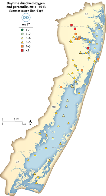
Although the Coastal Bays are shallow lagoons which typically do not stratify, oxygen values were frequently low in some areas. Dissolved oxygen (DO) data sources show that Bishopville Prong, Shingle Landing Prong, areas of the St. Martin River, dead-end canals and some areas in Chincoteague Bay have poor fish and crab habitat (DO < 3mg/L) during summer months. Additional areas that have DO levels below the state criteria of 5 mg/L include Ayer, Trappe, Newport, Marshall Greys, Manklin, Herring and Turville Creeks, as well as areas in Chincoteague Bay. Areas that have < 5 mg/L DO during the day may provide stressful habitat at night.
Previous year assessments
- 2004-2007
- 2001-2003
- 1999-2001
No trends are calculated on dissolved oxygen due to the rapid daily changes
Continuous Monitoring Results
Data from the continuous monitoring stations reveal more insight into the annual changes in oxygen is the coastal bays.
Elgin report
Ecosystem Health Assessment 2007-2013 -DO Chapter
Current conditions
