Information
At 49,000 acres, Green Ridge is the largest contiguous block of public land in Maryland. Green Ridge is located within the Ridge and Valley Province of the Appalachian Mountains. It is rich in both natural and cultural heritage and remains a “working forest” today as it is managed by the Maryland Department of Natural Resources Forest Service to conserve the natural ecological processes while supporting the economy of the region through an active forest management program. The Maryland Forest Service Mission is to restore, manage, and protect Maryland’s trees, forests, and forested ecosystems to sustain our natural resources and connect people to the land.
Background
The general geographic boundaries of Green Ridge are Town Creek to the west and Sideling Hill Creek to the east. The northern boundary extends to the Mason-Dixon Line. The southern boundary parallels the Potomac River. Elevations range from 500 feet above sea level on the Potomac River to 2,000 feet on Town Hill. Green Ridge receives the least amount of rainfall in Maryland, averaging 36 inches annually.
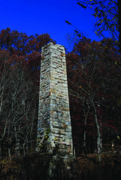 In the early 1800’s, Richard Caton and William Carroll in partnership owned much of the land that is Green Ridge State Forest today. Richard Caton was the son-in-law to Charles Carroll of Carrolton, a signer of the Declaration of Independence. William Carroll was the grandson of Daniel Carroll of Rock Creek, a framer of the United States Constitution. The land was originally patented from vacant lands during the 1820-1840 period for inclusion into various timber and mining interests, primarily the Town Hill Mining, Manufacturing, and Timber Company. This business venture was financed by the estate of Charles Carroll of Carrollton. The crumbling stone structure known as the Carroll Chimney, part of the steam-powered sawmill built in 1836, is the only known surviving structure of that period.
In the 1880-1912 era, most of the remaining virgin forest was cut and a period of neglect resulted in numerous wildfires. During the early 1900’s, the Mertens family of Cumberland attempted to convert the forest into apple orchards and promoted it as “The Largest Apple Orchard in the Universe.”
The orchard was subdivided into 10-acre parcels and sold to individuals as investment properties. Five acres of each property parcel was cleared, burned, and planted into apple trees. The remaining five acres had the best trees cut and the poorer trees were left standing. The orchard company went into bankruptcy in 1918. The interests of the corporation were acquired by the State Department of Forestry in 1931.
The first forest management activities at Green Ridge were performed by the Civilian Conservation Corps (CCC) in the 1930’s. Their main focus was fire control. Other work consisted of building roads, trails, recreation enhancements, and the management of existing forest for its future timber and wildlife potential.
During World War II, the CCC camp at Fifteen Mile Creek housed German prisoners of war who were required to cut pulpwood in the forest. As the forest grew it became popular with outdoor enthusiasts, especially hunters. It also contributed more and more to the local wood products industry.
Today, Green Ridge is a diverse forest consisting primarily of a 110 year old even-aged mixed oak forest with a wide variety of age classes resulting from various silvilculture activities beginning in the late 1960’s.
