Because of the important role that forests can play in protecting water quality and habitat, several projects have been initiated in targeted watersheds. Most of the projects have occurred in watersheds selected by the Maryland Clean Water Action Plan as priority watersheds in need of restoration. One project, CBIG Special Rivers, predated CWAP, but most of its focus areas were identified later as watersheds in need of restoration.
Potomac Watershed Partnership
The PWP is a large-scale, community-based watershed restoration partnership initiated by the USDA Forest Service (www.potomacwatershed.net) in 1999. MD DNR Forest Service is partnering with Virginia Department of Forestry, Pennsylvania Department of Environmental Protection, Potomac Conservancy, Ducks Unlimited, and the George-Washington/Jefferson National Forest, as well as many local groups and agencies. The partnership has six major goals for restoring and protecting the Potomac River watershed:
- Sharing watershed knowledge;
- Restoring streamsides and wetlands;
- Promoting land protection and stewardship;
- Reducing wildfire and forest health risks;
- Creating more livable communities; and
- Sustaining and expanding partnerships.
The Potomac Watershed Partnership integrates forestry program efforts to focus on the targeted watersheds in Maryland, the Monocacy, Antietam, and Catoctin drainages. Stewardship, fire, and urban programs are coordinated to improve watershed condition, and additional resources are available to encourage greater implementation and technical assistance for watershed-friendly practices.
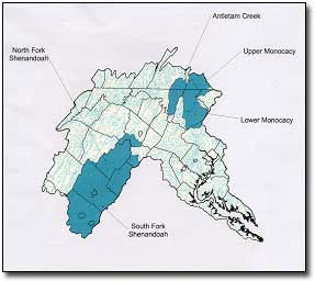
After three years, the PWP has resulted in substantial progress in watershed restoration and coordination in Maryland, including:
- Created 2,500 acres/149 miles of riparian forest buffers in focus watersheds;
- Prepared forest stewardship plans for acres of private forest land;
- Drafted a characterization of natural resource conditions in Monocacy and Antietam Basins;
- Initiated a new forest management plan for the Frederick City Watershed lands;
- Established nineteen riparian forest buffer effectiveness monitoring sites;
- Promoted WATER, Watershed Actions To Encourage Restoration, at local events in focus watersheds;
- Initiated a Backyard Buffer program to encourage planting of suburban buffers;
- Developed fire response plans for three high-risk fire communities;
- Installed dry hydrants in critical rural locations, aided by the statewide fire risk mapping;
- Rehabilitated 10 miles of fire roads;
- Mapped urban forest canopy in Frederick and Hagerstown to assist in locating future planting projects; and
- Assisted with new PWP initiatives like Growing Native (www.potomac.org/growingnative), a volunteer native tree seed collection effort that gathered over 15,000 pounds of nuts last year.
> Back to Top
Special Rivers Chesapeake Bay Implementation Grant
The Special Rivers Project has been funded since 1983 by the US Environmental Protection Agency to improve water quality for the Chesapeake Bay by encouraging the restoration, enhancement, and management of forests (Chesapeake Bay Implementation Grant Clean Water Act Section 117(b)). Forests provide the greatest level of benefits for water quality and habitat of any major land use and are critical to sustaining watershed health. The project helps implement several important goals in the Chesapeake Bay Agreement, including riparian forest buffer restoration, watershed planning, stream corridor restoration, land conservation and stewardship, and community engagement. The Special Rivers Project was the first watershed-based forestry initiative for the MD Forest Service, and has helped stimulate the formation of the forest watershed management program now in place.
Goals include:
- Restoration, monitoring and maintenance of riparian forest buffers that reduce nutrients in streams (at least 30 miles/year);
- Forest stewardship planning that improves management of private and public forests (at least 1,800 acres/year);
- Education and outreach on benefits of forests for watersheds and water quality (at least 600 people/year, including students, general public, and resource professionals).
Since 1983, the Special Rivers project has helped create over 5,580 acres of forest buffers, prepared forest stewardship plans for over 53,000 acres, and presented forest benefits information to over 45,000 people since inception. Additional displays and exhibits have reached over 330,000 residents of the Chesapeake Bay watershed.
The Special Rivers Project has four project areas that have been established since 1983: Susquehanna area watersheds starting in 1983, Monocacy area watersheds starting in 1986, the Anacostia watershed starting in 1991, and the Town Creek Ecosystem Management Project starting in 1994.
The Susquehanna area project now encompasses 2,125 square miles, from the Elk River in Cecil County to the upper and middle Patuxent watersheds in Howard and Montgomery County. It includes Deer Creek, Bush River, Gunpowder, Jones Falls, Gwynns Falls, and Patapsco watersheds, in Baltimore, Carroll, and Harford Counties.
The Susquehanna area project, with the diversity and extent of its project area, has been able to accomplish substantial afforestation in rural areas, reach urban audiences, and be involved in important watershed planning efforts. Special River foresters in the Susquehanna have helped over 850 people prepare forest management plans to improve forest condition on 16,493 acres. Over 1,500 acres on upland sites and over 2,000 acres along streams and shorelines have been planted. The project has helped coordinate with Tributary Teams, prepare exhibits on benefits of trees in local parks, and assist with watershed planning for the Gwynns Falls, Little Patuxent, Octoraro Creek, and Liberty Reservoir watersheds. The project has supported training for local students involved in the state and national Envirothon competition , helping to turn out some top-ranked teams at the national level. In addition, professional training for forest harvesting Best Management Practices, multiple-use forest management, and resource protection has been presented.
Future work will continue to focus on essential forestry actions that support Chesapeake Bay commitments, including riparian forest buffer restoration, survival monitoring, forest stewardship planning, watershed-level planning, and invasive species control. The project will continue to lead efforts for outreach and education that better inform citizens in the watershed on the ways that forestry can help improve the habitat and water quality in the Chesapeake Bay.
The Monocacy area project covers 1,300 square miles in Upper and Lower Monocacy, Double Pipe, Catoctin, Antietam, Conococheague, Licking Creek and adjacent direct drainages to the Potomac River. The project area is dominantly rural agriculture, although suburban development has expanded rapidly, posing additional stresses on the stream and watershed natural resources. The Monocacy project implements forest practices including riparian forest buffers, forest stewardship plans, and forest harvest evaluation to improve watershed condition. Extensive outreach and education efforts include training students in forestry and natural resource issues for the Envirothon competition. Some past accomplishments include:
- Over 400 forest buffers on over 3,300 acres;
- Over 700 forest stewardship plans on over 27,000 acres;
- Over 850 acres of afforestation outside of streamside buffers;
- Ongoing survival monitoring and maintenance practices;
- Over 600 acres of timber harvest inspections for sediment and erosion control with local District Forestry Boards;
- Presentations and exhibits reaching over 38,000 people;
- Management plans for the Monocacy Natural Resources Management Area and Ft. Detrick;
- Partnerships with local community associations and schools for restoration projects;
- Frederick City Greenways Plan identifying afforestation opportunities.
The Anacostia/West Chesapeake project is a pilot for urban forestry efforts to improve water quality and habitat even in the most heavily developed areas, serving portions of Prince George’s, Montgomery, and Anne Arundel Counties. The Anacostia project is currently implemented in partnership with the Metropolitan Washington Council of Governments and the Anacostia Watershed Restoration Agreement. Past accomplishments have included:
- Over 50 acres of urban riparian forest buffers;
- Plantings on commonly overlooked green spaces by stormwater management ponds and on golf courses;
- Locating sites for stream restoration projects;
- Detailed targeting mapping for riparian forest buffer establishment in the Sligo Creek subwatershed;
- Outreach to landowners with unbuffered waterways;
- Professional training on urban forestry techniques;
- Over 200 presentations and exhibits on forest and tree care and benefits, reaching 15,000 people;
- Coordination with a US EPA restoration grant to help produce a multi-media outreach package for the Anacostia, including a web site, poster, and video, highlighting the river’s history and efforts for recovery.
The Town Creek project, initiated in 1994, is a pilot project for locally-led ecosystem management. The Town Creek watershed is in Allegany County, Maryland and Bedford County, Pennsylvania. Watershed planning and restoration efforts cross jurisdictional and ownership lines, driven by the leadership of local community groups such as the Town Creek Steering Committee and the Town Creek Watershed Landowners Association. Some achievements of the Town Creek Ecosystem Management Project include:
- The Long-Range Planning Guide for Town Creek and 12 guiding principles;
- Regular newsletters to share progress and relevant information with landowners;
- Annual field trips to share information on positive practices and projects;
- Over 30 buffer sites covering more than 150 acres for riparian forest buffer sites;
- Over 50 forest stewardship plans for more than 6,000 acres;
- 415 acres of stand improvement projects;
- Presentations and exhibits reaching over 4,000 people.
The biggest success and most necessary step for the project has been building trust in the project and among the participants that it supports the mutual benefits and long-term interests of the community and resources. The Town Creek project is increasingly being seen as a model for local watershed and ecosystem management, with several surrounding watersheds initiating similar projects and capitalizing on the project’s experience.
> Back to Top
Coastal Bays Forestry Strategy
The Coastal Bays of the Atlantic Ocean have many stresses and conditions similar to the Chesapeake Bay, but are not covered by the Chesapeake Bay Agreement and are not eligible for Chesapeake Bay funding. Consequently, a separate Maryland Coastal Bays Management Plan has been developed with assistance from the Maryland Coastal Zone Management Program . The MD Forest Service, with financial assistance from EPA Clean Water Act Section 319(h) funding, undertook focused efforts to support forest-related goals for the Coastal Bays, including both environmental goals for forest extent and forest interior species habitat, and also quality of life goals for maintaining rural character and viable working forests.
The Coastal Bays Forestry Initiative was designed to improve the information basis for pursuing goals of the Coastal Bays Management Plan and enhance progress in forestry actions. The Coastal Bays Forestry Strategy compiled current forest inventory information, compared forest area and species composition to available historical data, and presented insect defoliation data for the five watersheds in the Coastal Bays. Trends in forest species distribution, harvest rates, and conversion to development were identified. Programs to assist private landowners in afforestation or forest management were summarized. This information was used to identify issues and opportunities relating to the forest-related goals in the Coastal Bays Management Plan as of 2001. The document was supplied to and benefited from the comments of the Coastal Bays Forestry Work Group, which was preparing a white paper on forestry issues in the Coastal Bays.
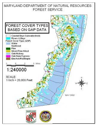
The grant also supported technical assistance for riparian forest buffers in the Coastal Bays watersheds, areas not included in the Chesapeake Bay Riparian Forest Buffer Initiative. From less than 3 miles per year prior to the grant, buffer planting increased to 5.3 miles (126 acres) in 2000 and 14.05 miles (216 acres) in 2001, substantially exceeding the 10-mile goal.
The northern Coastal Bays offer the greatest opportunities for integrating forests in a developing landscape. This can include greater attention in development design and retention of open space or afforestation, as well as the use of trees to ameliorate environmental stresses in a developed environment, using urban forestry. Urban forest benefits include temperature moderation and stormwater processing. Forest retention of buffers and corridors can contribute to habitat and water quality goals. State and federal easement programs are concentrated in the southern Coastal Bays watersheds, so opportunities to permanently protect key habitat areas in the northern portions could be increased.
The southern Coastal Bays watersheds offer the greatest opportunities to retain working landscapes in a sustainable fashion that supports a rural economy and lifestyle. These areas would be suitable for efforts to educate landowners on the value of retaining forest land uses and other methods of forest management that can meld their goals of returns on investment and wildlife, water quality, or aesthetics. Both the Forest Legacy and Rural Legacy Programs have priority areas in the Southern Coastal Bays watersheds. A Forest Legacy easement has already been obtained for a significant forest parcel in Chincoteague Bay watershed.
> Back to Top
Maryland Forests for Healthy Watersheds
Maryland’s Forests for Healthy Watersheds map was developed to target the forested watersheds of Maryland that help filter and keep Maryland waters clean. The map was designed to take values assigned to attributes of forests that affect water quality, such as steep slopes or headwater streams and add them together to create a “model.” The higher the value, the more important it is to keep the area forested so it can continue providing natural benefits to the watershed.
Forests are one of the most cost-effective ways to balance ecology and economic uses, and keep watersheds healthy. The specifics of where forests are most effective will vary from place to place, but there are some general principles and practices that apply widely.
Read  Forests for Healthy Waters, Sustainable Communities to get more information.
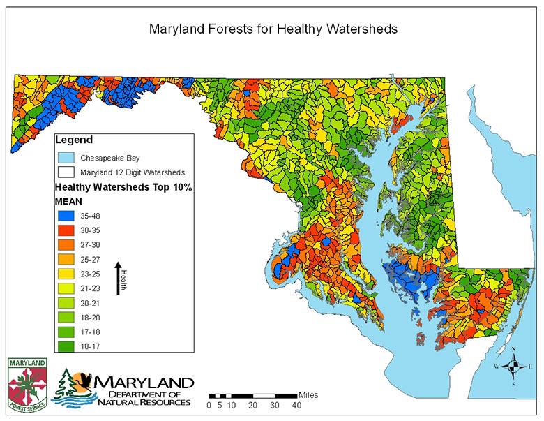
A matrix showing the different parts of the model is below. A description of the layers and reasoning for them follows.
Maryland's Forests for Healthy Watersheds |
Scoring |
|
10 |
7 |
5 |
3 |
1 |
0 |
Important Forest Resource Layers |
|
Percent of watershed forested (12 digit) |
>80 |
60 - 79 |
40 - 59 |
20 - 39 |
<20 |
N/A |
100 Foot Forested Buffer of streams, coasts, lakes |
Present |
|
|
|
|
Absent |
Floodplains |
Present |
|
|
|
|
Absent |
Wetlands |
Present |
|
|
|
|
Absent |
Steep slopes |
25% |
|
15% |
|
|
Absent |
Headwater wetlands and headwater streams in forest interior |
Present |
|
|
|
|
Absent |
Green Infrastructure Hubs |
Tier 1 |
Tier 2 |
Tier 3 |
|
|
Outside |
Water quality for nutrients and sediment |
|
Nitrogen efficiency ranking (based on hydrogeomorphic regions) |
85% removal |
60%-70% removal |
45% -55% removal |
40% removal |
25% removal |
N/A |
Phosphorus efficiency ranking (based on hydrogeomorphic regions) |
75% removal |
70% removal |
65% removal |
60% removal |
50% removal |
N/A |
Saturated Hydraulic Conductivity (Ksat) |
.9-27.4 |
27.4-63.8 |
63.8-138.3 |
138.3-232.6 |
>232.6 |
Not Rated |
Percent of Watershed Forested: A general rule of thumb is that the more forest there is in a watershed, the healthier the waterways. High forest cover in watersheds is beneficial to many terrestrial and aquatic species too. Brook trout for example exist in streams where their sub-watersheds are 100% or near 100% forested.
This layer was created by taking Maryland 12 digit watersheds and calculating percent forest cover using Zonal Statistics in ArcMap.
100 Foot Forested Buffer of Streams, Coasts, Lakes: Forested buffers within 100 feet of waterways capture runoff and sediment before they can reach the stream. Furthermore, the roots of the trees have the ability to filter nutrients out of groundwater and stabilize stream banks, reducing erosion.
This layer was created by buffering the USGS National Hydrologic Dataset flowlines by 100ft and clipping forest cover to it.
Floodplains: Floodplains are areas along waterways that are able to accommodate excess water and energy during and after storm events. When a river or stream breaches its banks, it loses energy and drops some of its sediment. When trees and other vegetation are present they are able to capture and filter the deposited nutrient-rich sediment and reduce the energy of the flowing water.
This layer is from Federal Emergency Management Agency and Maryland Department of Environment.
Wetlands: Wetlands are living filters for large amounts of water. As water flows through a wetland the specially adapted plants are able to filter out nutrients and capture sediment.
This layer was developed by Maryland Department of Natural Resources.
Steep Slopes: Steep Slopes are important to keep forested because the trees and their roots help stabilize the soil and keep it from eroding away.
This layer was developed from 30m National Elevation Dataset.
Headwater Wetlands and Headwater Streams in Forest Interior: Headwaters are where a stream starts. If the headwaters are forested and clean, the waterways stay cleaner further into the watershed.
This layer was developed with the USGS National Hydrologic Dataset, Maryland Department of Natural Resources Wetlands, and Maryland Forest Cover.
Green Infrastructure Hubs: Green Infrastructure is a network of large forest blocks (Hubs) connected by forested corridors that allow wildlife to live and travel with relative ease. The larger the forest block, the chances are higher that the water will be cleaner coming out of it.
This layer was developed by Maryland Department of Natural Resources.
Nitrogen Efficiency Ranking (based on hydrogeomorphic regions): This layer assigns a value to how well different geomorphic provinces filter out nitrogen from ground water. Higher efficiencies are given to geomorphic provinces with shallow subsurface flow where tree roots can access it.
The layer was developed by the USGS.
Phosphorus Efficiency Ranking (based on hydrogeomorphic regions): This layer assigns a value to how well different geomorphic provinces filter out phosphorus from ground water and surface water.
The layer was developed by the USGS.
Saturated Hydraulic Conductivity (Ksat): Refers to the ease with which pores in a saturated soil transmit water. Saturated hydraulic conductivity is considered in the design of soil drainage systems and septic tank absorption fields. When water moves slowly through the soil it gives tree roots a chance to filter out nutrients.
This layer was developed using Soil Data Viewer in ArcMap and NRCS Soil Survey Geographic Database (SSURGO).
> Back to Top