Maryland's Green Infrastructure Assessment Introduction
Maryland’s Green Infrastructure (GI) is our natural support system, providing ecosystem services that are necessary to humans, as well as plants and animals. As Maryland’s population increases, Green Infrastructure is being lost to development. Prior to European settlement, about 95% of Maryland’s six million acres of land was covered in forest. Today, forest cover is around 40%. In Maryland’s early post-colonial history, forest loss was due to agricultural conversion. In the early part of the 20th century, many marginal farms were abandoned and reverted back to forest. However, in the last half of the 20th century, urban development replaced an estimated 7,200 acres of forest land per year.
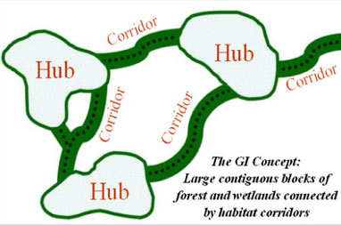
The scattered pattern of modern development not only consumes an extensive amount of land, it fragments the landscape, converting a once near-continuous stretch of forests and wetlands to small, isolated islands of habitat in a sea of developed land. Since a statewide comprehensive approach to address landscape fragmentation did not exist, Maryland’s Department of Natural Resources (DNR) began an effort in the late 1990’s to identify the most ecologically important lands in the State, Maryland’s
Green Infrastructure. The result of this effort is a mapped network of large blocks of intact forest and wetlands, called “hubs,” linked together by linear features such as forested stream valleys, ridgelines, or other natural areas, called “corridors.” An essential characteristic of
Green Infrastructure is the interconnection of its features.
In addition to the Original Green Infrastructure, the DNR had developed three other statewide databases based upon extensive scientific work. Like the Original Green Infrastructure, each database scored land throughout the state.
The three databases are sometimes called Rare Species Habitat, Aquatic Life Hotspots and Water Quality Protection.
- The Rare Species Habitat database includes additional habitats that support rare, threatened and endangered species.
- The Aquatic Life Hotspots database adds watershed land and streams that support areas of high aquatic biodiversity.
- The Water Quality Protection database focuses on those watershed lands, such as forests, wetlands and steep slopes that are most important for improving water quality services.
How the Green Infrastructure is Being Used
The Green Infrastructure is now incorporated in the Targeting System and the Rural Legacy Grant Review System. Although the Green Infrastructure is not the only factor, it is certainly very significant in the DNR's efforts to best use its limited land protection funds.
