 A buffer is something that lessens or absorbs the shock of an impact. That is exactly what the Critical Area Buffer is intended to do, lessen the impact of people living and working within the Chesapeake Bay and Atlantic Coastal Bays watersheds. Development within the watershed has increased the number of roads and buildings which in turn results in greater amounts of stormwater runoff. The runoff carries sediment and pollutants to tidal creeks, rivers, and the Bays. These pollutants have a negative effect on the water quality and habitat values of the Chesapeake and Coastal Bays.
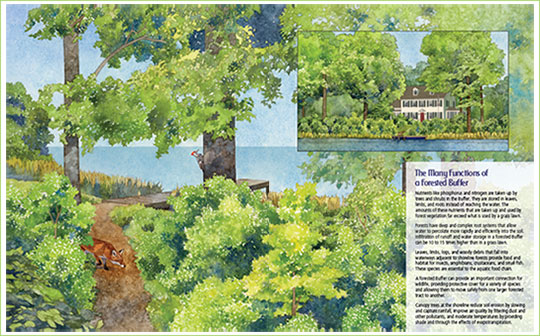
The Critical Area Buffer is the area of at least one hundred feet located directly adjacent to the State’s tidal waters, tidal wetlands, and tributary streams. Ideally, this Buffer is composed of trees, shrubs, and other plants that catch sediments and other pollutants coming from buildings, lawns and paved areas.
There are a number of significant environmental benefits of maintaining a protected Buffer between developed land and adjacent waters and wetlands. These benefits include:
- Reducing the amount of sediment, excess nutrients, and potentially harmful substances in stormwater runoff
- Preventing or reducing erosion by stabilizing slopes and the shoreline
- Maintaining an area of habitat along shorelines and streams
These Buffer functions can be grouped into three general categories:
- Water quality management
- Habitat protection
- Management of human activities
Buffers protect the Bays’ ecosystems from many of the negative impacts associated with development activities in the watershed. For this reason, a protected Buffer is considered an essential element of the Critical Area Program. State regulations and all local Critical Area ordinances require the establishment and maintenance of a minimum 100-foot Buffer adjacent to all tidal waters, tidal wetlands, and tributary streams. In general, new development activities that result in disturbance to land or natural vegetation or that involve the construction of a structure or result in new lot coverage are not permitted in the Buffer. The regulations regarding the Buffer and development activities were significantly revised in 2010 and minor changes were made in 2012.
The Buffer is measured from mean high water, from the landward edge of tidal wetlands, and from the edge of streams located within the Critical Area. The Buffer is expanded beyond 100 feet in areas where there are adjacent sensitive resources such as steep slopes or soils with development constraints. More detailed information about the Buffer can be found in  The Green Book for the Buffer (95.73 MB).
Critical Area Buffer Management
 This Buffer Resources Guide was developed through a partnership between the Critical Area Commission for the Chesapeake and Atlantic Coastal Bays and Adkins Arboretum. Financial assistance was provided by the Coastal Zone Management Act of 1972, as amended, administered by the Office of Ocean and Coastal Resource Management (OCRM), National Oceanic and Atmospheric Administration (NOAA), through the Maryland Department of Natural Resources Chesapeake and Coastal Program pursuant to NOAA award No. NA09NOS4190170.
Download the Complete Critical Area Buffer Resources Guide
