Patapsco Valley State Park Trails
 Patapsco Valley State Park extends along 32 miles of the Patapsco River,
encompassing 16,043 acres and eight developed recreational areas.
Recreational opportunities include hiking, fishing, camping, canoeing,
horseback and mountain bike trails, as well as picnicking for individuals or
large groups in the park’s many popular pavilions.
Patapsco Valley State Park extends along 32 miles of the Patapsco River,
encompassing 16,043 acres and eight developed recreational areas.
Recreational opportunities include hiking, fishing, camping, canoeing,
horseback and mountain bike trails, as well as picnicking for individuals or
large groups in the park’s many popular pavilions.
The park is nationally known for its trail opportunities and scenery. We
have 170 miles of trails, with 70 of those miles identified as maintained
trails. There are hiker only trails and multi-use trails accessible from
many areas of Patapsco.
In one of Maryland’s first state parks (1907), the valley and its natural
resources have been enjoyed by the Native Americans, explorers, settlers and
present-day citizens. With its source in Frederick and Carroll counties, the
Patapsco serves the Port of Baltimore, and empties into the Chesapeake Bay.
The Avalon Visitor Center houses exhibits spanning over 300 years of history
along the Patapsco River. Housed in a 19th century stone dwelling in the
Avalon Area, the center includes a re-creation of a 1930’s forest warden’s
office.
Patapsco Valley State Park encompasses 16,000 acres and five developed
recreational areas. It is home to 170 miles of rugged, natural-surface
trails that climb the hillsides along the river, popular among mountain
bikers, equestrians and distance hikers. But one need not be a triathlete to
enjoy the park's amenities. For those looking for a less strenuous workout,
there is the Grist Mill Trail, a more moderate route and popular destination
for parents with children in strollers, families on biking trips and people
with disabilities. The Grist Mill Trail parallels the river for a mile and a
half and provides a close-up view of its scenic beauty, while leading past
numerous sites of historic interest.
In the fall of 2003, a new multi-use section of the trail opened near Ellicott City to enhance ADA- (Americans with Disabilities Act) accessible recreational opportunities. The origin
al section of the Grist Mill Trail connects the famed swinging bridge in the Avalon Area of the park to Lost Lake, a special fishing area for children under age 16, senior citizens and visitors with disabilities, and once a reservoir for the Avalon Iron and Nail Works and the Baltimore County Water Company. The 1.2-mile extension leads from the swinging bridge to the river's edge near Ilchester. The new segment brings the total amount of paved trails in the park to slightly more than 2 1/2 miles and extends the Grist Mill Trail to a distance of five miles.
Trail users stroll past several historic sites worth noting. The Patapsco
Valley's rich resources attracted entrepreneurs who harnessed the river's
waterpower for 18th and 19th century industries, and because of its
proximity to Baltimore, it served as a gateway between western Maryland and
the Chesapeake Bay. As a result, the valley was developed as a
transportation route and serves as a crossroads for the National Road,
regional turnpikes and the Baltimore and Ohio (B&O) Railroad. Remnants of
these early industries and the railroad can still be seen along the trail.
An observant cyclist or hiker may serendipitously find the ruins of the
Orange Grove Flour Mill, which opened in 1856, and the Bloede Dam, an
engineering feat of the early 20th century. It was the first hydroelectric
dam in the U.S. where the turbines are located inside its hollow core,
maximizing efficiency in power generation.
The original path of the B&O Railroad between Baltimore City and Ellicott
City (1830) is also here; these were the first 13 miles of railroad track
laid in the country. Horses drew the original rail cars while the steam
engine was being perfected. Relics from the B&O Railroad include portions of
the Patterson Viaduct and granite stringers that were used to hold the
earliest iron rails that formed the railroad.
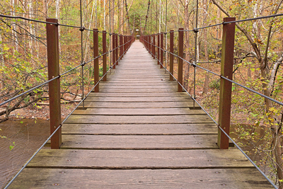
The park's legendary swinging bridge was once used by flour mill workers
walking from their homes in the town of Orange Grove on the west side of the
river in Howard County to the saw mills on the east side of the river in
Baltimore County. Visitors can also see railroad tanker ruins and the
lasting effects of erosion along the riverbank dating back to Tropical Storm
Agnes in 1972.
