Cranesville Swamp, Garrett County, MD & Preston County, WV
Cranesville Swamp is a boreal peat bog relic left behind from the Pleistocene Epoch. The swamp formed 15,000 years ago during the last Ice Age, when glaciers inched close but never reached Maryland. The climate warmed and the glaciers retreated but many of the boreal plants remain to this day. Nestled in a mountain valley bowl known as a frost pocket, colder conditions still prevail enough for plants to whisper of the past.
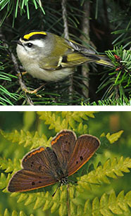 A trail hike through spruce and larch forest reveals the diverse character of the animals and plants that call Cranesville Swamp home. Visitors may hear the croak of a common raven flying overhead or see golden-crowned kinglets flitting about the branches. The trail through the forest leads to a boardwalk that takes visitors through the swamp where Endangered bog copper butterflies (Lycaena epixanthe) rest on the shrubs of Threatened small cranberry (Vaccinium oxycoccos). This protected area is one of the few boreal bogs still remaining in the southern United States and was one of the first National Natural Landmarks to be designated by the National Park Service in 1965. Cranesville Swamp is owned and managed by The Nature Conservancy.
Deep within the bog, small pockets of virgin forest remain, somehow missed by the logging locomotive named the Swamp Angel that passed directly through the wetland in the late 1800s. Red spruce and white pine trees have been restored by the thousands and the Natural Area now supports thriving populations of wildlife such as American beavers, bobcats and American black bears. Rare species also abound, including the Endangered southern water shrew (Sorex palustris punctulatus), several birds such as the diminutive northern saw-whet owl (Aegolius acadicus) and the increasingly rare Nashville warbler (Vermivora ruficapilla), as well as many dragonflies, damselflies and butterflies. Rare plants like the Endangered American larch (Larix laricina), a conifer that loses its needles in the winter, can be observed near the boardwalk. Other rarities are hidden away deep in the bog, like the Endangered creeping snowberry (Gaultheria hispidula).
From the Ice Age
Boreal bogs formed thousands of years ago when ponds filled with peat moss. Many bogs were mined to use their peat as a soil additive. Those that survived provide a glimpse of what much of North America looked like during the ice ages.
The Nature Conservancy
This site was protected by The Nature Conservancy in stages, beginning in 1960. Since that time, the Conservancy has acquired more than 600 acres which will be held in trust in perpetuity. Across Maryland, this far-sighted and capable organization has protected thousands of acres of our rarest and most significant Natural Areas.
 Click here for a Print Version of this map.
Cranesville Swamp Natural Area
Directions
From Frederick: Take I-70 west to I-68 at Hancock. Continue on I-68 about 65 miles to Exit 14. Follow US 219 (Garrett Hwy) south for 19 miles. Turn right (west) on Mayhew Inn Road, and after 1.4 miles turn left on Bray School Road. In 1.6 miles at the "T" intersection, turn right on MD 15 (Oakland Sang Run Road). After 1 mile, turn left on Swallow Falls Road and follow for 2.6 miles to a sign for Youghiogheny Mountain Resort. At the sign, take a hard right on Cranesville Road. After proximately 4 miles, turn left onto Muddy Creek Road and immediately park on the gravel behind the red house at the corner of the intersection. A kiosk with brochures, trail guides and other information can be found here. To get to the trailhead for the swamp, visitors must take a left back onto Cranesville Road and take the next left onto Lake Ford Road. Take a sharp right curve in the road and stay to the right at the fork. Stay to the right at the next fork in the road, and Cranesville Swamp is 0.2 miles down the gravel road. Park in the lot.
Driving directions and aerial views open with Google Maps. For the aerial view button, if an aerial view does not open by default, click on the Satellite icon in the upper right corner and Google Maps will switch to an aerial view of the Natural Area.