Bear Pen Run, Garrett County

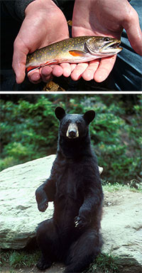
 Bear Pen Run Natural Area is located in the mountains of northeastern Garrett County. This Natural Area is named after the tributary which feeds into the Savage River. The Natural Area contains a varied topography that supports numerous spring wildflowers and songbirds within the mostly intact forest. In the spring, attractive, yellow flowers from the Threatened leatherwood (Dirca palustris) can be seen blooming in the understory. The rocky and cool mountain springs and streams which flow into Bear Pen Run provide habitat for a rich diversity of salamanders and native brook trout. This area was logged in the early 1900s, and the remains of the old, narrow-gauge railroad now provide an access trail through the woods. Patches of the forest which were untouched by logging now boast characteristics of old growth forests, such as live trees of many different ages and scattered dead trees both standing and decaying on the ground.
The contiguous forests within this Natural Area are a crucial component to maintaining water quality within the Savage River watershed. This watershed is important habitat for Maryland's native brook trout. The large, unbroken tract of forest also provides valuable habitat for forest interior dwelling species (FIDS). Many songbirds, American black bears, bobcats, fishers and salamanders survive best when provided with large contiguous patches of forest. Bear Pen Run is contained within the Savage River State Forest and is managed by the Maryland Forest Service.
Meet the Fishers
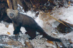
 Within the older, intact sections of Bear Pen Run, visitors might be lucky enough to catch a glimpse of the elusive fisher. Fishers are medium-sized members of the weasel family, and are one of the few critters bold enough to take on the North American porcupine. Fishers will quickly flip over the quilled animal to get at its unprotected underside. Despite their name, fishers do not eat fish, but they do eat a variety of other mammals such as rabbits and rodents. On rare occasions they will also eat fruits and mushrooms, usually when no other food source is available. These agile hunters are seldom seen, due to their nocturnal and solitary nature.
Pesky Plant
One threat to leatherwood and the forest within Bear Pen Run is the prevalence of the invasive Japanese spiraea (above left). This low-growing, clump-forming shrub rapidly forms dense stands, pushing out native species. Dedicated volunteer groups such as the Savage River Watershed Association annually pull this pesky plant in hopes of eradicating it from the area.
 Click here for a Print Version of this map.
Bear Run Natural Area
Special Note: Bear Pen Run Natural Area is used seasonally by hunters.
Directions
From Frederick: Take I-70 west to I-68 at Hancock. Continue west on I-68 for 56 miles and take Exit 24. Turn Left and head 0.4 miles south on Avilton Lonaconing Road to Lower New Germany Road. Turn right and go 3.7 miles to the intersection with Twin Churches Road. Turn left onto what will become Westernport Road and go 3.6 miles to Savage River Road. Turn right and go 4.1 miles to a small unmarked pull out at the Bear Pen Run Natural Area.


Driving directions and aerial views open with Google Maps. For the aerial view button, if an aerial view does not open by default, click on the Satellite icon in the upper right corner and Google Maps will switch to an aerial view of the Natural Area.
