Patuxent River Park, Prince George's County
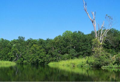
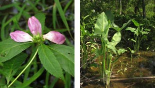
Bordering Jug Bay and extending south along the Patuxent River, the trails and boardwalks of Patuxent River Park provide easy access to the renowned tidal marsh system and the forested habitats of the region. A canoe launch near the north end of the Natural Area allows visitors to experience the sights and sounds of the marsh firsthand: the distinctive "whinny" of the rare sora (Porzana carolina) at dawn, bald eagles and ospreys soaring overhead at mid-day, and egrets roosting in the trees at sunset. A small boardwalk leads visitors through a tidal hardwood swamp with pumpkin ash, red maple and small patches of the Threatened red turtlehead (Chelone obliqua). This uncommon forest community grows at the edge of tidal influence, beyond the reach of brackish water, but is flooded regularly by the tides. Trails through the adjacent non-tidal and upland forests offer access to rich woodland areas dotted with ferns and wildflowers in spring. A four-mile Critical Area Driving Tour is open on most Sundays, and allows visitors to drive across Mattaponi Creek into the Merkle Wildlife Sanctuary. The road leads through dense woods, over non-tidal and tidal marshes and also through open farm fields.

This over-2,000 acre area is owned by the Maryland National Capital Park and Planning Commission (M-NCPPC) and the State of Maryland. The M-NCPPC property is managed as Patuxent River Park with both trails and a canoe launch available for the public. The State of Maryland property is managed as Merkle Wildlife Sanctuary. It contains hiking trails as well as the Driving Tour which connects both properties.
Sora Stopover
 The marshes along the Patuxent River are a critical stopover point for migrating soras and other birds. Patuxent River Park staff and others conducted research in the 1990s and discovered that soras rely on wild rice, smartweed, and other seed-bearing plants in these marshes to refuel during their journeys from their breeding grounds in New England and eastern Canada to their winter homes further south. After fattening up for weeks here, these strong fliers can make non-stop fall flights of 500 miles or more to reach marshes in Florida, the Caribbean, Latin America, or northern South America.
Turning of the Tidal Hardwood Swamp
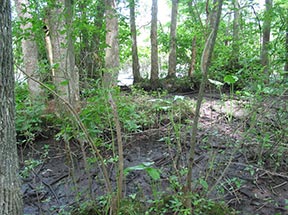
Tidal hardwood swamps such as those bordering the marshes of Patuxent River Park are considered in danger of extinction due to their limited ranges and their sensitivity to climate change. These freshwater forest communities are restricted to the fresh tidal portions of the coastal rivers of Virginia, Maryland and Delaware. Fewer than 100 of these communities have been documented worldwide, and many are threatened by rising sea levels as brackish water encroaches further upstream into formerly freshwater areas.
Click here for a Print Version of this map.
Patuxent River Natural Area
Special Note: Patuxent River Natural Area is used seasonally by hunters.
Directions
From Washington, DC: Travel I-95/495 (Capital Beltway) to Exit 11 and head east/south on MD 4 nearly 8 miles to the exit for MD 301. Head south on MD 301 for 1.6 miles to Croom Station Road. Turn left and follow Croom Station Road 1.6 miles to its end at Croom Road (MD 382). Turn left and proceed for 1.5 miles to Croom Airport Road. Turn left and continue for 2 miles to the Park entrance. From here, either continue straight to the Group Camp Area or turn left and proceed 1.7 miles to Park office and hiking trails.


Driving directions and aerial views open with Google Maps. For the aerial view button, if an aerial view does not open by default, click on the Satellite icon in the upper right corner and Google Maps will switch to an aerial view of the Natural Area.