 Mattawoman Creek, Charles County
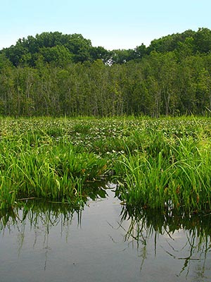
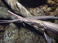
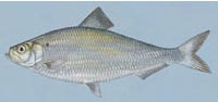
Paddle Mattawoman Creek from Mattingly Park upstream and experience the Chesapeake Bay in miniature. Follow the migration route of herring, shad and yellow perch to spawning sites in the upper Mattawoman drainage. The extensive wetlands and the large beds of submerged aquatic vegetation are a critical nursery and feeding grounds for fish, including these anadromous species as well as weakfish, spot, croaker and the rare longnose gar (Lepisosteus osseus). These areas are attractive to anglers for national fishing tournaments as well as to large fish-eating birds like herons, egrets, and bald eagles.
From the brackish marshes of the estuary near the put-in to the freshwater tidal forest and the nontidal marshes at the Route 224 bridge, the wetlands of this Natural Area are diverse and teeming with wildlife. The Indian Head Rail Trail offers views of the wetlands by bicycle or on foot from the north side of the creek. On the south side, a walk on the George Wilmot Trail
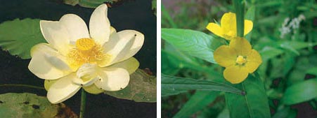
 reveals a variety of colorful forest songbirds in the spring and summer. This trail leads to several vantage points on the creek where almost 20 species of waterfowl can be seen in the fall as they stop over in large flocks to rest and feed before continuing on their journeys. The rare and elusive marshbird, king rail (Rallus elegans), can be found during the breeding season in the dense tidal freshwater marsh. In summer, visitors may see the beautiful flowers of the rare American lotus (Nelumbo lutea) floating on the open water of the creek. Native Americans consumed the potato-like tuber of this aquatic plant as well as the leaves and seeds, and may have spread the species for their use.
Mattawoman Creek Natural Area includes over 1,300 acres in northwestern Charles County. This area is one of Maryland's most significant natural resource areas, and the estuarine portions of the creek have been described by some as a model for a fully restored Chesapeake Bay. The Natural Area is owned by the State and is managed by the Maryland Park Service. Charles County manages the Indian Head Rail Trail.
Mattawoman NEA is pet-friendly within the rules of the Maryland State Park Pet Policy.
Forest Interior Dwelling Species
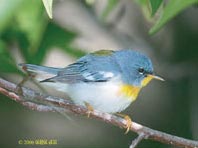 The intact, mature forests of the Mattawoman Creek watershed are prime habitat for Forest Interior Dwelling Species (FIDS). These species are mainly neotropical birds that migrate from Mexico and points south to the United States and Canada to breed in the summer. Among these colorful birds is the northern parula, a small warbler that nests in tree mosses. Pedal or hike the Indian Head Rail Trail to view these birds in spring and summer.
Spawning Saga
 Anadromous fish spend most of their lives at sea and migrate upstream into freshwater rivers to spawn. A decrease in spawning sites has been documented recently in Mattawoman Creek. Biologists are concerned that development activity in the watershed is reducing the water quality of this prized fishery. Forest clearing and runoff of stormwater from roads and buildings raise stream water temperature, increase the flow of water, which erodes stream banks, and cause sedimentation and pollution of streams. Local citizens have responded to the threats to this exceptional resource by assisting with stream monitoring, educating the public and partnering with county, state, regional and national organizations to work with government officials and private landowners to ensure protection of the watershed.
 Click here for a Print Version of this map.
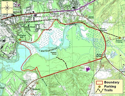
Mattawoman Creek Natural Area
Directions
From Washington, DC: Travel I-95 /495 (Capital Beltway) to Exit 3 at MD 210 (Indian Head Highway). Take MD 210 south about 18 miles to Indian Head. To launch a boat, continue through town about 2 miles and turn left onto Mattingly Avenue, just before the naval base gatehouse. Proceed 0.75 mile to the boat ramp at Mattawoman Creek. To reach the Indian Head Rail Trail, turn left (south) at MD 225. After 1.2 miles, turn left onto MD 224 (Livingston Road) and continue 0.4 mile to a parking lot on the left. To hike the George Wilmot Trail, from MD 210 turn left (south) at MD 225. After 1.6 miles, turn right on MD 224 (Chicamuxen Road) and continue 0.7 mile to Lackey High School on the left. The trailhead is off the right shoulder 0.3 mile beyond the school driveway. Look for small signs after the first telephone pole beyond a guard rail.


Driving directions and aerial views open with Google Maps. For the aerial view button, if an aerial view does not open by default, click on the Satellite icon in the upper right corner and Google Maps will switch to an aerial view of the Natural Area.