Jug Bay, Anne Arundel and Prince George's Counties
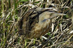
The magnificent wild rice marshes of Jug Bay draw both human and wildlife visitors to this Natural Area in summer and fall. Their graceful flowering heads produce food for waterfowl, and the marshes are a haven for numerous other birds, including rails, egrets, herons and the rare American bittern (Botaurus lentiginosus). A portion of the Patuxent River Trail runs through the tidal freshwater marshes at Jug Bay.
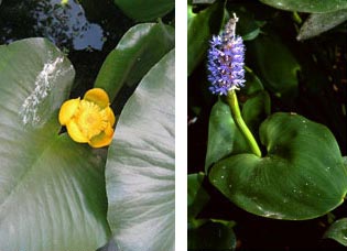
 Summer visitors can enjoy the colorful display of pickerelweed's purple flowers and yellow pond-lily's cup-shaped blooms bordering open water with acres of wild rice in the background. Boardwalks along the marsh edge invite visitors into the tidal shrublands and swamp forest that lie in the transition between steep upland slopes and open marsh. Trails in the upland woods cross through unusually dry, sandy forest that supports rare plants adapted to the droughty, low-nutrient soils. Pockets of wet woods contain vernal pools that fill with water in the fall and winter and dry in late spring and summer. Because they lack fish predators, these seasonal pools are vital breeding sites for amphibians. In the fall, a mass migration of marbled salamanders has been well documented traveling from the upland forest to the vernal pools to lay their eggs.

Much of Jug Bay Natural Area is part of the Jug Bay Wetlands Sanctuary which encompasses over 1,500 acres of protected land. The Sanctuary is operated by the Anne Arundel County Department of Recreation and Parks. Due to its status as a sanctuary, much of the Natural Area is only open to the public a few days a week. The Sanctuary is an estuarine site within the Chesapeake Bay National Estuarine Research Reserve System, Maryland (CBNERR-MD), a research and education program administered in cooperation with the National Oceanic and Atmospheric Administration (NOAA), Maryland's Department of Natural Resources (DNR) and Anne Arundel County. Among other issues, researchers are studying the effects of climate change, including changes in salinity, on the fragile tidal marshes. The water trail is managed jointly by DNR and county agencies.
Marbled Migration
Marbled salamanders spend much of their time underground. However, on rainy nights in September, hundreds of these chunky salamanders migrate to vernal pools to court and mate. After mating, the females will lay a mass of up to 200 eggs in the often dry vernal pool. When the pool fills with water, the eggs will hatch and larvae will develop. This reproductive strategy is very different from other salamanders which generally breed in the spring.
Out of the Box Eastern Box Turtle
The eastern box turtle is one of two species of box turtles found in the United States. These long-lived reptiles have a brightly patterned, dome-shaped shell, and are often found among the leaf litter throughout the woods at Jug Bay. Habitat loss and vehicular strikes while crossing roads have led to a significant decline in Maryland's box turtle population. In response, wildlife officials have placed the turtle on the list of Species of Greatest Conservation Need. Since 1995, Jug Bay Wetlands Sanctuary staff and volunteers have tagged and released over 500 eastern box turtles within the Sanctuary. When a tagged turtle is found, data is then collected and studied. This ongoing research has led to a better overall understanding of the box turtle's habitats and home range.
Special Note: Jug Bay Natural Area is used seasonally by hunters.
Click here for a Print Version of this map.
Jug Bay Natural Area
Directions
From Washington, DC:
on MD 4 about 10.5 miles to the exit for Plummer Lane. Exit right at Plummer Lane and proceed 0.5 mile to Wrighton Road. Turn right on Wrighton Road and continue about 0.6 mile to the Sanctuary entrance on the left. Follow the gravel drive about 0.6 mile to the Wetlands Center parking area.
Driving directions and aerial views open with Google Maps. For the aerial view button, if an aerial view does not open by default, click on the Satellite icon in the upper right corner and Google Maps will switch to an aerial view of the Natural Area.
