Potomac Gorge, Montgomery County, MD/Fairfax County, VA
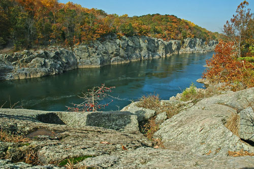 Over thousands of years, the powerful Potomac River carved out the Potomac Gorge, revealing the complex geology which, with the river, is the foundation of this extraordinary Natural Area. The landscape at Potomac Gorge includes the Great Falls of the Potomac, a series of dramatic cascades forced through narrow Mather Gorge as the river drops nearly 80 feet in elevation over less than a mile. This exceptional site provides habitat for over 60 rare plants and animals. The Gorge contains high rocky bluffs, ancient wooded river terraces, riverside outcrop barrens, gravelly scour bars, and prairies lush with warm season grasses. Floods from spring thaws and storm events are constantly reshaping the landscape as they scour the floodplains and riverbed. Thrill-seeking visitors can enjoy class I-IV rapids that snake through the dynamic landscape, while hikers can enjoy the sights along the gentle Chesapeake & Ohio Canal towpath or the more rugged Billy Goat Trail. In spring, the lush upland forests and floodplains are brilliantly decorated by a riot of wildflowers and songbirds, while temporary pools and side channels harbor choruses of frogs, wading birds and freshwater mussels.
This 1,900-acre Natural Area spans two states: Maryland and Virginia. Due to its location along the Fall Line between the Piedmont Plateau and the Atlantic Coastal Plain, the Potomac Gorge is one of the most geologically diverse places on Earth. Over time, the river has shifted south which has resulted in a more gentle, terraced landscape in Maryland compared to the steeper, dissected terrain in Virginia. It is believed that the terraces on the Maryland side represent base levels of the river as it eroded away bedrock. Potomac Gorge is managed by the National Park Service and The Nature Conservancy.
Mather Gorge
Mather Gorge is named for Stephen B. Mather, the first director of the National Park Service. The area around Mather Gorge is composed largely of sedimentary rocks. While these rocks are over 600 million years old, they surprisingly lack fossils. The rocks originated as sand and silt from the ancient Iapetus Ocean. Over time, the sediments cemented together while igneous rocks (formed from hot, molten lava) were injected between them. Today, both rock types can be seen along the Potomac Gorge.

Scour Power!
The wild Potomac River is one of the few large rivers in the eastern United States that lacks major dams, reservoirs or large-scale development along its banks. This allows natural floods to scour the islands and riverbanks which disrupts the growth of trees and shrubs and creates new habitats for rare wildflowers and early successional species.
Click here for a Print Version of this map.
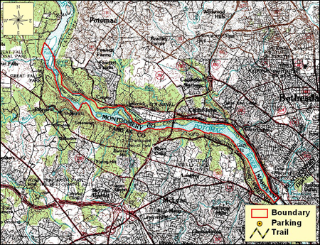
Potomac Gorge is a large Natural Area with several parking sites, visitor centers, and trails. A detailed map showing these features can be found at: http://www.nps.gov/choh/planyourvisit/upload/chohparkmap.pdf
Directions
From Washington, DC: Travel I-95/495 (Capital Beltway) to Exit 41 at Clara Barton Parkway. To reach the Great Falls Tavern Visitor Center near Mather Gorge and Bear Island, head north about 1.7 miles and turn left onto MacArthur Boulevard. Proceed nearly 3.5 miles to the Visitor Center. Other areas can be reached by driving south on Clara Barton Parkway from the Capital Beltway.


Driving directions and aerial views open with Google Maps. For the aerial view button, if an aerial view does not open by default, click on the Satellite icon in the upper right corner and Google Maps will switch to an aerial view of the Natural Area.

Driving directions and aerial views open with Google Maps. For the aerial view button, if an aerial view does not open by default, click on the Satellite icon in the upper right corner and Google Maps will switch to an aerial view of the Natural Area.
Acknowledgments
Scenic View of Potomac Gorge. Photo by: Gary Fleming
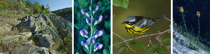
Wildlife Collage One: (left to right)
Photo by: Gary Fleming
Mather Gorge. Photo by: Gary Fleming
Spring Migrants like this beautiful male magnolia warbler concentrate along the Chesapeake & Ohio Canal. Photo by: Wikimedia Commons
In summer, �look among the rocky crevices at Mather Gorge for the rare riverbank goldenrod (Soli-dago simplex var. racemosa). This native sunflower �is threatened by�habitat loss. Photo by: R.H. Wiegand
Wildlife Collage Two: (left to right)
Rocky outcrops echoing with the thunderous roar of rapids, the Potomac Gorge's geologic diversity is truly spectacular. Photo by: Gary Fleming
Lush, gentle floodplains accented by spring wildflowers. Photo by: R.H. Wiegand
Potomac Gorge's scoured floodplains are a sharp contrast to its rocky out-crops. From mid-summer to fall, the plains are filled with stunning halberd-leaf rosemallows (a native hibiscus). Photo by: R.H. Wiegand
