Otter Point Creek, Harford County
 One of the largest remaining freshwater, tidal marshes within the upper Chesapeake Bay can be found at Otter Point Creek Natural Area. Here a large stand of wild rice attracts and feeds numerous wildlife, like the rare and elusive king rail (Rallus elegans), as well as a variety of waterfowl. The rare Maryland bur-marigold (Bidens bidentoides var. mariana) serves as a beacon for butterflies. American beavers, common muskrats, American minks and northern river otters can be found in these marshes, as well as aquatic turtles and the Threatened least tern (Sternula antillarum), a small colonial nesting waterbird that plunge-dives for fish. Visitors can access the Natural Area by canoe or kayak. The Natural Area is the focal point of the Otter Point Creek component of the Chesapeake Bay National Estuarine Research Reserve in Maryland (CBNERR-MD).
In addition to Otter Point Creek, two other sites make up the CBNERR-MD network: Monie Bay and Jug Bay. These three sites represent the diverse estuarine systems found within Maryland’s portion of the Bay. These reserves provide essential habitat for multiple fish species as well as the beloved blue crab, while also serving as sediment filters for the Bay and shoreline protection. The wetland area is owned by the Harford County Chapter of the Izaak Walton League of America, and the entire area is managed in cooperation with Harford County Department of Parks and Recreation and the Maryland Department of Natural Resources CBNERR-MD program. Information on the Otter Point Creek National Estuarine Research Reserve can be found on its website at: www.otterpointcreek.org. Otter Point Creek is also home to the Anita C. Leight Estuary Center, providing education, research and increased understanding of estuaries.
Wild About Rice
Wild rice is abundant along Otter Point Creek Natural Area. At one time, this marsh plant was a staple food to many Native American cultures. Despite its name, it is not related to the Asian rice which graces many tables throughout the world. Today, the main consumers of wild rice include marshbirds such as rails, as well as red-winged blackbirds and bobolinks which are also known as "rice birds".
The Izaak Walton League
Formed in 1922, the Izaak Walton League (IWLA) is one of America's oldest conservation organizations. The IWLA is an organization of grassroots volunteers that seeks to restore watersheds, reduce air pollution, protect wildlife habitat and open space and instill conservation ethics in outdoor recreationists. Protecting the wetlands at Otter Point Creek Natural Area is a great example of the IWLA’s approach to conservation. Improving conservation efforts in the Chesapeake Bay is one of the IWLA's priority regional projects.
Click here for a Print Version of this map.
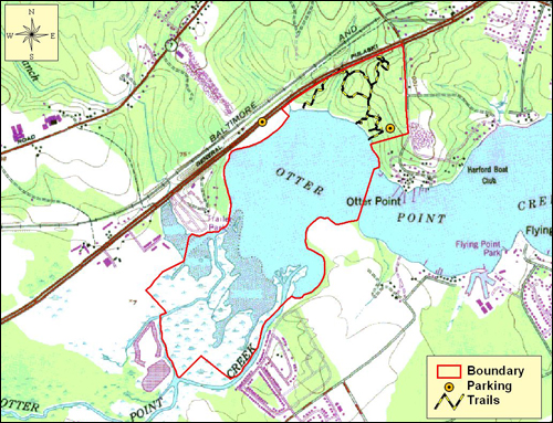
Directions
From Baltimore: Travel I-695 (Baltimore Beltway) to Exit 33 at I-95 and head north about 12 miles. Take Exit 77 onto MD 24 (Veterans Memorial Highway) south toward Edgewood. In 1 mile, turn left at the ramp for US 40 (Pulaski Highway) and left again in 0.2 mile to head east on US 40. Go 2 miles and turn right at the light for Otter Point Road. In 0.4 mile, turn right at the Anita C. Leight Estuary Center entrance.
To go to the Otter Creek Boat Ramp from the Estuary Center, turn right onto Otter Point Road. Make a slight right turn to stay on Otter Point Road and proceed another 0.2 mile to the boat ramp behind the Otter Point Marina.


Driving directions and aerial views open with Google Maps. For the aerial view button, if an aerial view does not open by default, click on the Satellite icon in the upper right corner and Google Maps will switch to an aerial view of the Natural Area.

Acknowledgments
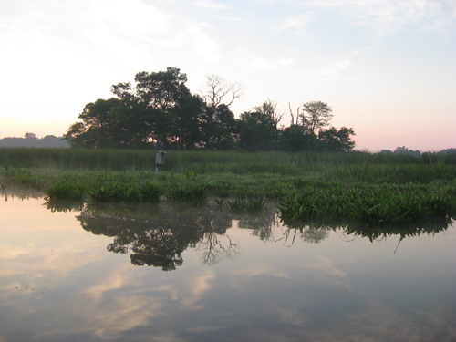
Scenic View of Otter Point Creek. Photo by: Patricia Delgado
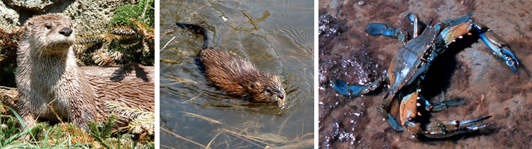
Wildlife Collage One: (left to right)
Look for playful northern river otters�and water-loving common muskrats among the marshes. Photo by: Ken Thomas/Wikimedia Commons
Water-loving common muskrat. Photo by: Wikimedia Commons
Blue crabs are found in both fresh and salt water. Photo by: NOAA/Wikimedia Commons
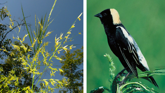
Wildlife Collage Two: (left to right)
Wild rice is the only grain native to North America and is an important food source for bobolinks. Photo by: Kerry Wixted
In breeding plumage, males are a striking black and white with a straw-colored patch on the back of the head. Females are a buffy, yellow-brown color. Photo by: USFWS
