History
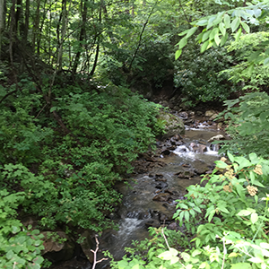
In February 2018, the Department of Natural Resources completed the purchase of 1,986 acres in southwestern Garrett County, outside the Town of Kitzmiller. The name, Wolf Den Run, was selected for the new State Park based primarily on a prominent stream located within the park boundary named Wolf Den Run. The stream name first appears on a Maryland Geological Survey Map of Garrett County dated 1901. Wolf Den Run flows through the northern section of the state park and empties into the North Branch of the Potomac River.
The State Park name was also selected based on more than 200 years of related historical references to the land. The earliest mention of the name was in 1788, in reference to land known as "Wolf's Den," which was acquired by Philip Bray, an early settler of the Kitzmiller area. The Bray farm comprised 100 acres on Military Lots 356 and 357, known locally as Wolf's Den, which were located on the mountain slope along what is now Route 38, around the area where the Bray cemetery is located. The historic Bray farm property is located on or near the Wolf Den Run stream and the current boundary of the State Park.
The land was mined by the Wolf Den Coal Company near the turn of the century. The town of Shallmar, which borders the state park on the North Branch of the Potomac River, received its name by reversing parts of the name of W.A. Marshall, who was the first superintendent of the Wolf Den Coal Company.
The reason for the references to a wolf den in association with the area is unknown; however, western Maryland was historically part of the red wolf range. The namesake has remained popular with contemporary private organizations, which have used the property for recreation purposes until the State's purchase.
