Trails
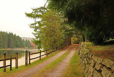
New Germany has ten miles of multi-use trails. The trails wind their way through dense hemlock forest, colorful mixed hardwoods, rhododendron-choked stream valleys and towering pine and spruce plantation sites.
Most trails are wide enough for two-way traffic, although several offer a narrower path typical of most hiking trails. Hiking, trail-running and biking are the most popular activities throughout the year.
Whether walking along the lake or wetland, or hiking our scenic trails, visitors are sure to have an opportunity to view birds and wildlife. Abundant bird species can be found throughout the area, such as pileated woodpeckers, black-capped chickadees, barred owls, great blue herons and an occasional osprey.
Capture the photo of a lifetime while exploring our majestic forests and wetland. Frequent sightings of deer, squirrels, fox and black bear bring visitors delight and a meaningful respect for the environment.
When snow is adequate, the park staff will groom and track the trail surface for skiing. Snowshoeing is permitted but snowshoe users must stay off the ski tracks.
Please see our
Winter Activities for more information on skiing at New Germany.
Note: Motorized vehicles are not permitted on New Germany’s trails.
Trail Descriptions
-
The Turnpike (green)
0.8 miles- EASY
This scenic trail follows Poplar Lick, a native brook trout stream. Cross-country skiers gave this trail its name based on the two-way traffic pattern that develops on busy weekends during peak ski season. Wide and flat, The Turnpike is ideal for family hiking, beginner mountain biking, and cross-country skiing. Several other trails can be accessed from The Turnpike. -
Gazebo Loop (black)
0.8 miles- EASY
This short loop features a unique log gazebo built by the CCC in the 1930’s. Perched on a small cliff, the gazebo provides a picturesque view of Poplar Lick. -
Orchard Loop (pink)
1 mile- EASY with a short, steep section
This short loop trail features a field that has been maintained as an apple orchard for many generations to honor the families and industry that existed in and around New Germany prior to the land being designated as a State Park. -
Hemlock Trail (yellow)
1 mile- MODERATE
This trail connects The Turnpike to McAndrew’s Hill Road, near the park entrance. This trail showcases New Germany’s towering eastern hemlocks, which can be especially beautiful when blanketed with snow. -
Ice House Loop (white)
1.2 miles- EASY to MODERATE
This trail extends from the beach area along the outer perimeter of the campground. Along this route was once an ice house, which was used to store ice cut from the pond in the days before electrical refrigeration. This trail also travels past the New Germany School, a one-room schoolhouse where grades 1-7 were taught in the early to mid 20th Century. -
Acorn Loop (blue)
1.1 miles- MODERATE
This trail can be accessed from The Turnpike, the Cabin Loop or the Dog Leg Trail. A small section of this loop is conjoined with the Cabin Loop and is therefore double-blazed (blue and red). -
Cabin Loop (red)
1.4 miles- MODERATE to DIFFICULT
This challenging trail can be accessed from the Cabin Road, and contains steep and rolling terrain. A small section of this loop is conjoined with the Acorn Loop and is therefore double-blazed (blue and red). -
Dog Leg Trail (orange)
1.4 miles- MODERATE to DIFFICULT
This challenging trail connects the Acorn Loop with the Dynamite Shack Loop. Named for its twists and turns, it can be a difficult run on skis, especially in icy conditions. -
Dynamite Shack Loop (purple)
2.5 miles- MODERATE to DIFFICULT
This challenging trail extends from The Turnpike, climbing over 400 feet of elevation, past remnants of an old dynamite shack used by the CCC in the 1930’s. There is also an easy, flat section that follows an old narrow-gauge railroad grade, which was used to haul timber in the late 1800’s.
Trail Map
A map of the trails at New Germany State Park can be downloaded for free from this website. Please make sure to read the printing instructions and information for how to download the file to cell phones. The map is in a PDF format that requires Adobe Reader.
To get the free Adobe Reader go to Adobe.com.
