Outdoor Activities and Amenities in Maryland
Main_Content
 | |
Public Lands - Accessible Park Trails | |
|
Center_Content
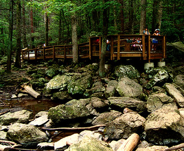
| Cunningham Falls: |
The Boardwalk Trail is .25 miles in length and is fully accessible. The trail ends at the base of the park's scenic 78-foot waterall. The Boardwalk Trail parking lot is open only to vehicles displaying the handicap accessible symbol. |
| Gunpowder Falls: |
This 21 mile abandoned railroad bed makes an ideal surface for hikers, bikers and horseback riders to enjoy. The rail trail, formerly the NCR Trail, has been officially renamed the Torrey C. Brown Rail Trail, in honor of Maryland's third Maryland Department of Natural Resources Secretary. Dr. Brown's vision was the major driving force in developing this multi-use recreational trail. |
| Martinak: |
Fitness/Activity Trail. Enjoy a leisurely walk on the paved Fitness Trail, which includes benches at several locations. When entering the park, pass the park office on the right. Just past the office, on the left is a gravel parking area. To begin walking on the .9 mile loop, walk on the gravel back towards the park entrance. The trailhead is there and exploration begins. The flora and fauna along the way includes, but is not limited to, high and low blueberry bushes, mountain laurel and a Caroline County champion loblolly pine tree. The trail is completely shaded. In addition, it challenges youth and those young at heart to complete the exercises that are posted while learning about animals and birds in the park.
|
| Merkle: |
Driving tour. |
| Patapsco Valley: |
The Tall Poplar Trail in the McKeldin area is a fun flowing trail that is roughly 4 -6' wide with sweeping turns and rolling contours. The trail resembles the single tract trails in the park but with a wider corridor and sightlines. The exposed roots and rocks on this trail are easier to navigate and can be rolled over with greater ease. The trail is great for kids learning to ride, older individuals who would like a less challenging trail and those who may be recuperating from an injury and would like to try to get back on the trails, and of course those who use the wider adaptive bikes. The Grist Mill Trail is an approximately 2.5 mile paved trail that connects Lost Lake and Ilchester Road. The trail includes two suspension bridges. The Swinging Bridge connects Baltimore County and Howard County across the river at Orange Grove and Cascade Falls Trail. The Patterson Viaduct Footbridge connects the park to Ilchester Road for through foot and bike traffic. This is not an intended entrance into the park as there is no legal parking on Ilchester Road. |
| Tuckahoe: |
Tuckahoe State Park: Fishing path. Park at the lake's boat ramp (710 Crouse Mill Road, Queen Anne) and enjoy a short paved ADA path to an ADA fishing platform that extends out over beautiful Tuckahoe Lake. From the parking spots to the platform it is only 420-feet and the pathway itself is 248-feet in length; all fairly level.
|
| Western Maryland Rail Trail: |
The WMRT currently offers 28 miles of flat, paved trail surface. The eastern terminus of the trail, known as Big Pool Station, is located ½ mile west of historic Fort Frederick State Park in Washington County, Maryland. Many visitors begin their WMRT excursions here although some prefer to start at the western terminus located in Little Orleans, Maryland. The WMRT parallels the C&O Canal for its entire length. Pit-toilet is available at Big Pool parking lot year-round, and port-a-pots are available at Pearre and Little Orleans parking lots seasonally. Indigo Tunnel By-Pass - The Indigo Tunnel is home to eight different bat species. Due to the decline in the bat population the tunnel is closed to the public. Between Mile Markers 24 and 27, the tunnel is bypassed by ramps to the C&O Canal Towpath. The bypass is two miles long due to a bend in the Potomac River. The surface of the towpath is for the most part an even hard-packed dirt trail. The towpath can be very muddy following heavy rain. For information regarding the C&O Canal Towpath please visit: https://www.nps.gov/choh/index.htm |

