The printed version of the Code of Maryland Regulations (COMAR) is the official and enforceable text. Only the official text may be judicially noticed under Courts and Judicial Proceedings, Section 10-203, Annotated Code of Maryland. For the complete, searchable, text of these regulations access the Maryland Division of State Documents.
08.02.01.06 - Code of Maryland Regulation
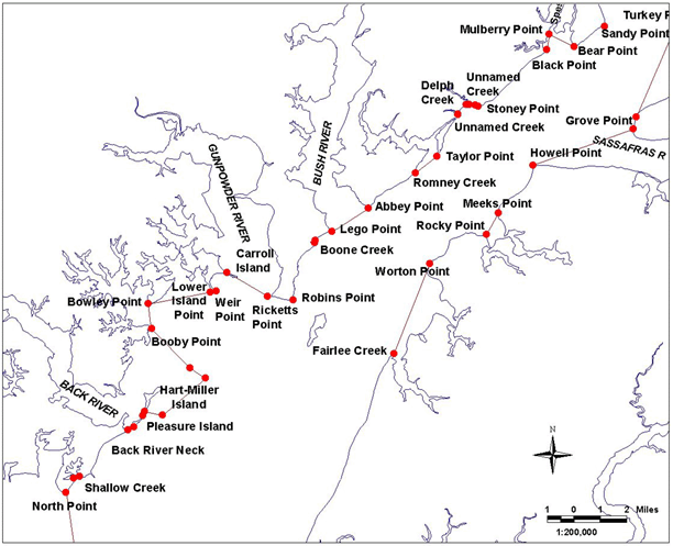
Bay Definition, Map No. 6
.06 Dividing Lines of the Chesapeake Bay, Sounds and Straits.
A. The boundaries set forth in §B of this regulation are designated as official dividing lines of the Chesapeake Bay, sounds and straits.
B. Any creek, cove, or other tributary less than 100 yards in width that intersects any segment of the following delineating lines shall not be a part of the described area.
(1a) Chesapeake Bay, Western Shore. - Description reads south to north.
Continued south on bay Map #5.
...to a point at or near North Point, defined by Lat. 39°11.72' N and Long. 76°26.53' W; then running northeasterly along shore to a point at or near the west entrance of Shallow Creek, defined by Lat. 39°12.19' N and Long. 76°26.20' W; then running approximately 71° True to a point at or near the east entrance of Shallow Creek, defined by Lat. 39°12.25' N and Long. 76°25.95' W; then running northeasterly along shore to a point at or near the east end of Back River Neck, defined by Lat. 39°13.76' N and Long. 76°23.91' W; then running approximately 65° True to a point at or near the west end of Pleasure Island, defined by Lat. 39°13.85' N and Long. 76°23.65' W; then running northeasterly along shore to a point at or near the east end of Pleasure Island, defined by Lat. 39°14.23' N and Long. 76°23.27' W; then running approximately 26° True to a point at or near the west end of Hart-Miller Island, defined by Lat. 39°14.36' N and Long. 76°23.19' W; then running easterly along shore to a point at or near the south end of Hart-Miller Island, defined by Lat. 39°14.23' N and Long. 76°22.44' W; then running northeasterly along shore to a point at or near the east end of Hart-Miller Island, defined by Lat. 39°15.44' N and Long. 76°20.62' W; then running northwesterly along shore to a point defined by Lat. 39°15.78' N and Long. 76° 21.28' W; then running approximately 316° True to a point at or near the east end of Booby Point, defined by Lat. 39°17.07' N and Long. 76°22.88' W; then running approximately 353° True to a point at or near Bowley Point, defined by Lat. 39°17.89' N and Long. 76°23.01' W; then running approximately 80° True to a point at or near Lower Island Point, defined by Lat. 39°18.25' N and Long. 76°20.39' W; then running easterly along shore to a point at or near Weir Point, defined by Lat. 39°18.30' N and Long. 76°20.15' W; then running northerly along shore to a point at or near the east tip of Carroll Island, defined by Lat. 39°18.89' N and Long. 76°19.68' W; then running approximately 121° True to a point at or near Ricketts Point, defined by Lat. 39°18.11' N and Long. 76°17.97' W; then running easterly along shore to a point at or near Robins Point, defined by Lat. 39°17.97' N and Long. 76°16.90' W; then running northerly along shore to a point at or near the south entrance of Boone Creek, defined by Lat. 39°19.85' N and Long. 76°15.97' W; then running approximately 23° True to a point at or near the north entrance of Boone Creek, defined by Lat. 39°19.92' N and Long. 76°15.94' W; then running northeasterly along shore to a point at or near Lego Point, defined by Lat. 39°20.21' N and Long. 76°15.25' W; then running approximately 58° True to a point at or near Abbey Point, defined by Lat. 39°20.97' N and Long. 76°13.69' W; then running northeasterly along shore to a point at or near the south entrance of Romney Creek, defined by Lat. 39°22.11' N and Long. 76°11.70' W; then running approximately 52° True to a point at or near Taylor Point, defined by Lat. 39°22.66' N and Long. 76°10.79' W; then running northeasterly along shore to a point at or near the south entrance of an unnamed creek, defined by Lat. 39°24.02' N and Long. 76°09.89' W; then running approximately 12° True to a point at or near the north entrance of an unnamed creek, defined by Lat. 39°24.04' N and Long. 76°09.88' W; then running northeasterly along shore to a point at or near the west entrance of Delph Creek, defined by Lat. 39°24.35' N and Long. 76°09.52' W; then running approximately 96° True to a point at or near the east entrance of Delph Creek, defined by Lat. 39°24.34' N and Long. 76°09.40' W; then running easterly along shore to a point at or near the west entrance of an unnamed creek, defined by Lat. 39°24.33' N and Long. 76°09.15' W; then running approximately 112° True to a point at or near Stoney Point, defined by Lat. 39°24.29' N and Long. 76°09.01' W; then running northeasterly along shore to a point at or near Black Point, defined by Lat. 39°26.11' N and Long. 76°06.11' ...
Continued north on bay Map #7.
(1b)Chesapeake Bay, Eastern Shore. - Description reads north to south
...then running approximately 204° True to a point at or near the north side of Grove Point, defined by Lat. 39°23.87' N and Long. 76°02.34' W; then running southerly along shore to a point at or near Grove Point, defined by Lat. 39°23.49' N and Long. 76°02.47' W; then running approximately 251° True to a point at or near Howell Point, defined by Lat. 39°22.33' N and Long. 76°06.72' W; then running southeasterly along shore to a point at or near Meeks Point, defined by Lat. 39°20.77' N and Long. 76°08.21' W; then running approximately 210° True to a point at or near Rocky Point, defined by Lat. 39°20.07' N and Long. 76°08.73' W; then running southeasterly along shore to a point at or near Worton Point, defined by Lat. 39°19.14' N and Long. 76°11.13' W; then running approximately 202° True to a point at or near the west entrance of Fairlee Creek, defined by Lat. 39°16.19' N and Long. 76°12.67' W; then running southerly along the shore...
Continued south on bay Map #5.
