"LAND CONSERVATION IS FISH CONSERVATION"
Mattawoman Creek Land Conservation = Resource Conservation: Conserving the Resources Left
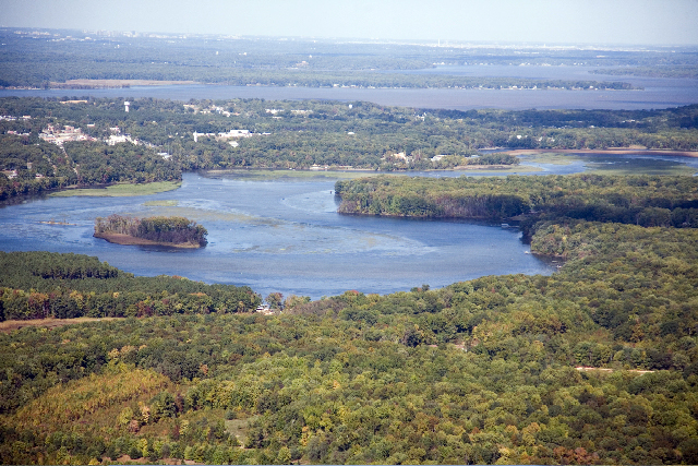 Mattawoman Creek, a 30 mile long tributary to the Potomac River, is located within Prince George's and Charles Counties and supports a diverse, high quality aquatic ecosystem. In fact, Mattawoman Creek Watershed (encompassing 94 square miles) is ranked 8th out of the 137 watersheds in Maryland for freshwater stream biodiversity and is one of the most productive spawning areas for anadromous (shad and herring) and a diverse tidal fish community. Furthermore, Mattawoman Creek is a well-known area prized for its largemouth bass fishery, drawing high-profile tournaments and anglers from all over the country throughout the year. Mattawoman Creek is filled with abundant and rare natural resources, offering residents and visitors the chance to observe a stunning environment that once surrounded the entire Chesapeake Bay. Unfortunately the Chesapeake Bay, including Mattawoman Creek, is deteriorating due to increased development.
 To see the beauty and natural resources found within Mattawoman Creek and Charles County watch the video,
Charles County - A Maryland Treasure produced by Maryland Department of Natural Resources for the citizens of Charles County.
To see the beauty and natural resources found within Mattawoman Creek and Charles County watch the video,
Charles County - A Maryland Treasure produced by Maryland Department of Natural Resources for the citizens of Charles County.
During the last year, the Maryland Department of Natural Resources worked together with Charles County Planning Department, Maryland Department of Planning, Department of Environment, State Highway Administration, US Fish and Wildlife Service and EPA to review the development and state of the Mattawoman Waterhed. A report named
“The Case for Protection of the Watershed Resources of Mattawoman Creek: Recommendations and Management Initiatives to Protect the Mattawoman Ecosystem” was prepared with the findings and submitted to Charles County that provided a series of recommendations to the County in the interest of protecting the natural resources found within Mattawoman Creek and Charles County.
 Planning for growth is very important for Mattawoman Creek's fish and fisheries, Maryland Department of Natural Resources Fishing and Boating Services biologists realize that the habitat of fish and future of fishing is linked to conserving forests, wetlands, and working farms; therefore, a fisheries resources section workgroup consisting of biologists from Maryland Department of Natural Resources Fishing and Boating Services and Tidewater Ecosystem Assessment met over several weeks to offer fisheries management advice as part of a broad effort to provide recommendations to Charles County for their comprehensive development plan. Posted below is Section 2: Mattawoman Creek Fisheries Resources prepared by the above mentioned workgroup that is found in the report "The Case for Protection of the Watershed Resources of Mattawoman Creek: Recommendations and Management Initiatives to Protect the Mattawoman Ecosystem".
Reports and Publications are available on this archival webpage.
These documents are not ADA Compliant.
To request a particular report, follow the directions at the top of the linked page.
Section 2: Mattawoman Creek Fisheries Resources
Recommendations to support County Planning Program Direction from the Fisheries Resources Section Workgroup
Jim Uphoff, (MDNR), Margaret McGinty (MDNR), Ross Williams (MDNR), Mary Groves (MDNR), Justin Falls (MDNR), Joe Love (MDNR), Nancy Butowski (MDNR), Marek Topolski (MDNR), Tom Parham (MDNR), Steve Minkkinen (MDNR), Bob Sadzinski (MDNR)
Part 1: Planning for Growth in Mattawoman Creek: What it Means to Fisheries
Planning for growth is very important for Mattawoman Creek's fish and fisheries because development affects water quality and quantity. Problems from development flow from Mattawoman Creek's stream to its estuary.
Natural land allows rain and melted snow into the ground because it is porous and this water slowly discharges through the ground into streams (NRC 2009). Swamps and marshes store surface runoff water temporarily and allow it to slowly flow back into streams. Development turns natural areas into paved surfaces, buildings, and compacted soils that surface water cannot penetrate. These hard (impervious) surfaces increase runoff and decrease water that soaks into the ground (NRC 2009).
Impervious surface increases flow extremes (lower lows and more flooding), erosion, and sediment (NRC 2009; Wheeler et al. 2005; Uphoff et al. 2011). As trees are lost, runoff temperature increases. Nutrients from developed lands can be as plentiful as from agriculture and cause algae blooms that deplete oxygen (NRC 2009). In winter, more roads require more salt that pollutes streams and kills freshwater organisms, including fish (Wheeler et al. 2005). Other pollutants such as toxic metals (lead for example) and organic pollutants (oil, grease, and pesticides) enter waterways in urban runoff and wastewater (Paul and Meyer 2001; Wheeler et al. 2005). Some compounds that enter wastewater treatment facilities may not be removed. These compounds may reduce success of fish spawning and make fish less safe to eat. Fish become less abundant and less diverse in polluted waters that result from high development and impervious surface (Wheeler et al. 2005; Uphoff et al. 2011a).
Maryland Fisheries Service has chosen counts of structures per hectare (1 hectare = 2.47 acres) from Maryland Department of Planning (MDP) tax map data as our indicator of development. Tax map indicators are standardized, annually updated, readily accessible and based on observed quantities (structure counts or structure area). Tax map indicators of development are strongly related to impervious surface estimated from satellite images. Impervious surface estimates made by different satellite image interpretation techniques generally agree in trend, but may indicate different percentages of impervious surface. The MDP annually updates tax maps for Maryland's 23 counties, while impervious surface estimates are made intermittently from satellite images. We estimate that Mattawoman Creek had about 10-15% of its watershed in impervious surface in 2009 based on several statistical methods that convert (MDP) property tax map structure counts to percent impervious surface estimates compatible with Towson University satellite interpretation.
Structures per hectare in Mattawoman Creek's watershed equaled 0.88 in 2009. We have compared this level of development to provisional levels of watershed development that are favorable and safe (a target), or unfavorable, unsafe, and to be avoided (a threshold) for productive fisheries and aquatic habitats.
Fisheries managers do not have authority to manage land-use, so they have to consider managing fish differently at different levels of development. The target level of development for fisheries is indicated by about 0.4 structures per hectare or less. This target level of development in Maryland is characterized by forests, working farms, and wetlands that support productive fish habitat and fisheries. Land-use at this level does not undermine effectiveness of harvest controls for sustaining fish populations. Preserving watersheds at this level of development would be ideal. Once above this level of development, increasing consideration has to be given to habitat preservation and revitalization. Lowering harvest levels may be able to offset habitat degradation.
The threshold of development of 0.7 structures per hectare represents a suburban landscape where serious aquatic habitat degradation becomes apparent. At this point, conservation of remaining natural lands and habitat revitalization will be the primary tools for fishery sustainability. Harvest restrictions may be ineffective in stemming fishery declines. By 1.2 structures per hectare, serious habitat problems make fish habitat revitalization very difficult. Managers must deal with substantially less productive fisheries. Cities consist of even higher levels of development and most aquatic life cannot tolerate resulting habitat conditions (NRC 2009). However, concentrating growth into already developed areas saves rural lands that create the best conditions for fish. Well-planned development lessens the need for cars and roads, and saves open lands needed to support healthy watersheds and waterways.
Maryland Fisheries Service realizes that the habitat of fish and future of fishing is linked to conserving forests, wetlands, and working farms. Conserving these areas to the maximum extent possible for fisheries is the best advice we can give to any county as they renew their comprehensive development plan.
Part 2: Assessment of the Quality of Mattawoman Creek's Fisheries Resources and Recent Trends.
Mattawoman Creek's Fisheries
Mattawoman Creek supports commercial and recreational fisheries, either directly from the catchable sized fish that reside there or as a productive nursery for fish in their first years of life. Fishing provides affordable protein for those that eat their catch, income to business people selling catch or the catching experience (guides), and an opportunity to enjoy nature for those who mostly return their catch to the water.
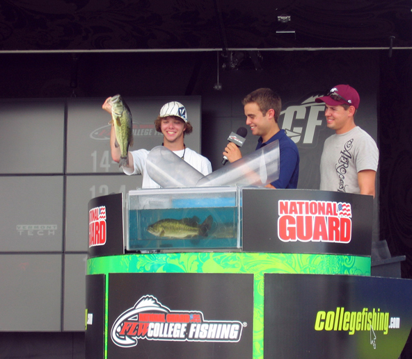
Based on our observations, Mattawoman Creek supports one of the steadiest and busiest recreational fishing destinations in Maryland. There is ample access for both shore-based and boat recreational anglers in Mattawoman Creek. Shore access is particularly important for low-income anglers and is limited in Maryland. Recreational anglers visiting Mattawoman Creek may have as little invested as a rod, reel, hooks, and bait to as much as trucks, trailers, and tackle tailored for largemouth bass fishing that have a combined worth of more than $100,000. Beyond purchase of a fishing license, bait, tackle, and boats, additional expenses occur for vehicles capable of towing boats, fuel, insurance, vehicle and boat maintenance and repairs, meals, and lodging for out-of-towners. Recreational fishing in Mattawoman Creek generates business opportunities for tackle shops and a cadre of largemouth bass guides. Mattawoman Creek is often a featured stop for national largemouth bass fishing tournaments sponsored by large businesses such as BASS and FLW. These tournaments feature hundreds of contestants, draw thousands of spectators, and are covered nationally in print, on the internet, and on television. An influx of visitors is drawn to Mattawoman Creek because of bass tournaments and many out-of-towners stay in local hotels and eat in local restaurants. These nationally covered tournaments provide free advertising that draws additional anglers from all over the country. Yellow perch fishing in Mattawoman Creek and fishing for large (50+ pound) blue catfish in nearby Potomac River waters have garnered national attention in In-Fisherman magazine. An opportunity to catch northern snakeheads in Mattawoman Creek has drawn anglers and guides as well.
Commercial catches may be sold for consumption or bait through local, interstate, or even international markets. Commercial fishermen are not limited to fishing in Mattawoman Creek and roam a large area of the tidal Potomac. Some fish harvested (carp, gizzard shad, eels, and even snakeheads), but not all (catfish, striped bass, yellow perch, and white perch), are of limited interest to recreational anglers. During 2008-2010, top commercial fish harvested in the same region of the tidal Potomac River as Mattawoman Creek (Route 301 Bridge and upstream) were Atlantic menhaden (a baitfish), blue catfish, striped bass, and channel catfish (88% of 2.25 million pounds of all finfish species harvested in the region over these three years; Ellen Cosby, Potomac River Fisheries Commission). Income generated from the sale of seafood purchases workboats, marine engines, trucks, refrigerators, plus costs for nets and other fishing supplies, labor, baskets, boxes, and business-related taxes and licenses.
Until recently, fisheries managers have largely focused on providing access, managing harvest, and minimizing conflicts among angler groups fishing Mattawoman Creek. Angler conflicts have occurred between tournament-based and non-tournament anglers, and recreational and commercial fishermen. These conflicts may become more contentious as development occurs and productive habitat is undermined. Decline of habitat reduces catches and fishing opportunities and increases complaints about fishing quality. Expenditures on habitat restoration and hatchery activities increase, while fishing license revenues decline. Fisheries Service has identified three major habitat-related fisheries management issues in Mattawoman Creek: conservation of the largemouth bass fishery, loss of anadromous fish spawning and nursery habitat, and a decline of the tidal fish community.
Largemouth Bass in Mattawoman Creek
A little under half of Maryland's freshwater anglers target largemouth or smallmouth bass (collectively, black bass; USFWS 2008). The specific contribution by black bass anglers to the economy of Maryland is not known. However, during 2006 anglers spent and estimated $568,000,000 on fishing in Maryland and nearly 3-times as many days were spent fishing for black bass than any other species in fresh or saltwater in Maryland (USFWS 2008). Thus, black bass angling likely contributes heavily to the amount of money anglers spend in Maryland. In Charles County, fishing, boating and water-related activities generated more than $40 million per year and were the largest visitor and local resident activity under tourism (Reardon 2007).
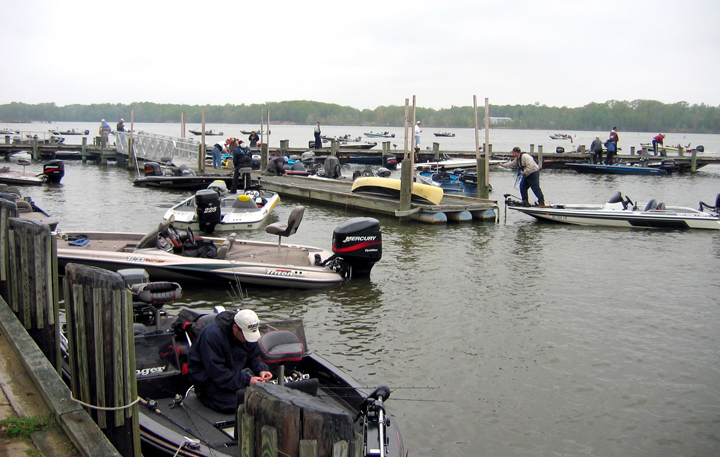 More largemouth bass fishing tournaments occur at Smallwood State Park (on Mattawoman Creek) than anywhere else in Maryland. Across a full year (1999), Charles County's Office of Tourism estimated that tournament fishing for largemouth bass generated $7,000,000 there (J. Roland, unpublished, Charles County Economic Development Department). In 2010, a single large FLW tournament based at Mattawoman Creek, but also fishing the tidal Potomac River, generated $700,000 (D. Simmons, FLW Outdoors, personal communication). In a study conducted in Texas, most revenue from black bass tournaments went to counties or cities (Chen et al. 2003).
The fate of released bass is very important to the Potomac River fishery. Largemouth bass fishing tournaments occur nearly every weekend from April to October and thousands of fish are released into Mattawoman Creek at the marina. This continuous release of bass replenishes Mattawoman Creek. These fish require suitable habitat quality and oxygen levels to recover from handling stress. Fish kills of largemouth bass have been observed after tournaments in recent years, with counts of as many as 600 dead bass. Multiple causes were suspected, but oxygen readings were low.
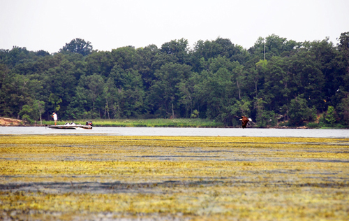
 In Maryland's portion of Chesapeake Bay, the most productive largemouth bass fisheries occur in fresh-tidal areas that have stable sediment levels, salinities, and nutrients (Love 2011). High sediment loads from development can smother bass nesting sites. Sediment and algae blooms fueled by nutrients carried by sediment cloud the water and reduce growth of underwater grasses that are important for hiding and feeding. Feeding success of largemouth bass may be reduced by poor water clarity that reduces ability to see prey. In addition to sedimentation and water clarity, low oxygen levels can threaten the vitality of largemouth bass. Low oxygen can occur when nutrient-rich waters promote substantial growth of primary producers such as algae and grasses. A continuous water quality monitoring device in a dense submerged aquatic vegetation (or SAV) bed at the Sweden Point Marina has detected episodes of critically low oxygen during summer. Fisheries Service purchased and deployed an oxygenator at the marina in 2011.
Fisheries managers are increasingly concerned that the largemouth bass fishery in Mattawoman Creek will decline as development increases. Limiting future suburban sprawl, redeveloping existing areas into livable, more densely populated urban neighborhoods that absorb more people per area, and conserving remaining natural areas and working farms are important for maintaining Mattawoman Creek's high quality bass fishery.
Anadromous Fish Spawning and Nursery Function
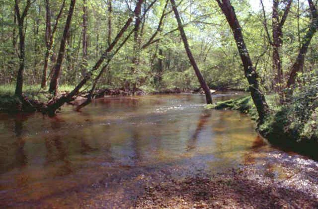
Mattawoman Creek's anadromous fish, herring (alewife and blueback herring primarily), white perch, and yellow perch spawn in Mattawoman Creek's stream and upper tidal reach during March through May. A1971 survey detected herring spawning upstream as far as Billingsley Road; white perch spawning was documented as far upstream as Route 227; and yellow perch spawning was detected at Route 225 (Uphoff et al. 2011b). Little change in anadromous fish stream spawning in Mattawoman Creek was indicated between 1971 and 1989-1991 as structures per hectare went from 0.16 to 0.45; however, by 2008-2010 stream spawning by all three groups became more sporadic: herring spawning sites were reduced from 6 locations to 2-4; white perch sites fell from 1-2 to 0-1; and yellow perch spawning at Route 225 was not detected in 2009, but was detected in 2008 and 2010 (Uphoff et al. 2011b). The percentage of stream samples with herring eggs dropped from nearly 70% in 1991 to 8-40% during 2008-2010 (J. Uphoff, MDDNR, unpublished analysis).
Other case studies indicate that stream spawning of white perch, yellow perch, and herring diminished with increasing development. Between 1971 and 2008-2009, stream spawning of anadromous fish largely ceased (5 sites to 0-1) as Piscataway Creek developed from 0.48 structures per hectare to 1.41 (Piscataway Creek is adjacent and closer to Washington D.C. than Mattawoman Creek; Uphoff et al. 2011b). Stream surveys of anadromous fish spawning in Bush River (Maryland, north of Baltimore) during 1973 (0.30 structures per hectare) and 2005-2007 (1.15-1.21 structures per hectare) did not detect a change in herring spawning sites; herring spawning occurred at 8 sites in 1973 and 7-11 sited during 2005-2007 (McGinty et al. 2009). However, spawning sites generally declined for white and yellow perch (from 8 to 0-2 for white perch and from 4 to 0-4 for yellow perch; McGinty et al. 2009). We compared annual percentages of samples with anadromous fish eggs or larvae collected during 2005-2008 between relatively undeveloped section of Bush River's watershed (Aberdeen Proving Grounds or APG; approximately 0.25 structures per hectare) and the remainder of the watershed that was highly developed (1.24-1.30 structures per hectare). Where development was low, herring eggs and larvae were twice as likely to be present in stream samples and yellow perch larvae were 20-times more likely. White perch spawned in streams in APG, but eggs and larvae were not found in streams in the developed portion of Bush River's watershed (J. Uphoff and M. McGinty, unpublished analysis). Alewife and white perch egg and larval densities in Hudson River tributaries likewise declined strongly with development (Limburg and Schmidt 1990).
Loss of stream spawning in Mattawoman Creek reflected changes in stream flow and water chemistry. When structures per hectare were less than 0.7 structures per hectare, there was no relationship between flow magnitude and flow variability for Mattawoman and Piscataway creeks (1950-2009). However, when there were more than 0.7 structures per hectare, flow magnitude was negatively related to flow variability. Mattawoman Creek's flow pattern shifted from that of a rural watershed with a substantial groundwater influence to a suburban one with mostly surface flow. Urbanization affects both discharge and sediment supply of streams that, in turn, affects location, substrate composition, and success of spawning. Estimated loads of sediment in Mattawoman Creek were elevated in comparison to those for the agricultural Choptank River watershed (Gellis et al. 2008).
Elevated conductivity (a measure of water's ability to conduct electricity) has emerged as an indicator of urbanization (Uphoff et al. 2010). Most inorganic acids, bases, and salts are relatively good conductors of electricity. Elevated conductivity in developed areas is related primarily to increased roads and use of road salt. Conductivity measurements in mainstem Mattawoman Creek were elevated beyond historic levels during 2008-2010 (particularly in 2009) and increased with distance from where the stream and estuary met. During 1970-1989, Mattawoman Creek's stream mouth and the stream in the vicinity of Waldorf were areas of elevated conductivity, while conductivity was low for about six miles in between (Uphoff et al. 2010).
Use of salt as a road deicer leads to both acutely toxic "shock loads" of salt and elevated average concentrations that are associated with decreased fish and benthic organism abundance and diversity (Uphoff et al. 2010). Elevated stream salinity increases osmotic stress of fish eggs and larvae and lowers survival. Commonly used road salt anti-clumping agents can break down into toxic cyanide under exposure to ultraviolet light and have been implicated in fish kills. Changing stream chemistry may disrupt upstream migration of anadromous fish. Physiological details of spawning migrations of herring and perch are not well described, but homing migration in other anadromous fish has been attributed to chemical composition, smell, and pH of natal streams (Uphoff et al. 2010).
Absence of detectable stream spawning does not necessarily indicate an absence of spawning in the estuarine portion of these systems. Neither yellow perch nor white perch appear to be dependent on stream spawning, but stream spawning may confer benefit to the population through expanded spawning habitat diversity (Kraus and Secor 2004). Stream spawning is very important to shore anglers because yellow perch become accessible. The effect of lost stream spawning on the other anadromous species may be different as both blueback and alewife herring ascend streams much further than yellow or white perch (Uphoff et al. 2011b). Shore access to fish such as yellow perch, white perch, and herring during their spring spawning runs depends on maintaining a healthy stream.
The upper portion of Mattawoman Creek's estuary (Indianhead to Route 225) is an important nursery for yellow perch larvae and it is monitored (as are other areas) by towing a conical, fine-mesh nets during late March to late April (Uphoff et al. 2011b). The proportion of tows with yellow perch larvae is a simple measurement of larval relative abundance that integrates egg abundance and hatching success, and survival of early larvae. These are important processes that vary naturally, but they are also negatively affected by contaminants, sediment, and disruption of zooplankton production.
Based on data collected throughout Chesapeake Bay since 1998, development is negatively related to the proportion of tows with yellow perch larvae (larval index) and the larval index was typically higher in fresh-tidal than brackish subestuaries (Uphoff et al. 2011b). Larval indices for Mattawoman Creek during 2008-2010 were within the same high range as minimally developed Nanjemoy Creek in two of three years and were higher than indices from more developed Piscataway Creek. Yellow perch larval feeding success in 2010 in five Chesapeake Bay subestuaries, including Mattawoman Creek was negatively influenced by development. Feeding success in Mattawoman Creek was lower than less developed Nanjemoy Creek and higher than more developed Piscataway Creek. Adequate zooplankton supply and successful feeding of larvae are considered critical factors for survival (Uphoff et al. 2011b).
Years of high spring flow favor anadromous fish recruitment in Chesapeake Bay and may represent favorable episodes that deliver accumulated organic matter from the watershed to the estuary (Uphoff et al. 2011b). This organic matter fuels higher production of zooplankton that larvae feed on. Land-based organic matter largely supported one of the most successful year-classes of American shad in Virginia's York River, while lesser year-classes were associated with low flows, organic matter based on phytoplankton, and lesser zooplankton production. The amount of organic matter present in samples during 2011 was negatively related to development. Urbanization affects the quality, quantity, timing, and delivery of organic matter in streams as riparian zones and floodplains become disconnected from stream channels by stormwater management as small streams are buried into culverts and pipes, or paved over. Development-related changes in quality, quantity, and timing of organic matter delivered to subestuaries could decrease zooplankton production or alter timing of spring blooms important for feeding success and survival of anadromous fish larvae (Uphoff et al. 2011b).
Tidal Fish Community
Abrupt declines in both the number of species (or species richness) and relative abundance of all species in channel waters of Mattawoman Creek began in the early 2000s at about 0.7 structures per hectare. These abrupt declines indicated that an ecological tipping point (threshold) had been reached. Number of species and relative abundance had varied from year to year without a trend prior to this decline.
 Mattawoman Creek's channel habitat has been sampled with trawls continuously since 1989. Seines have been used as well, but extensive SAV growth after 2003 precluded their use. Trawls used during 1989-2002 were smaller and less efficient than those used since 2003. Both gears have been used since 2009 to understand how this gear change may have affected habitat evaluation. Average number of species collected annually in the small trawl during 1989-2002 was 14.6. Only two species were observed in the small trawl collections during 2009 and five were observed in 2010. Large trawls caught between 27 and 29 species during 2003-2005 and species counts fell to 13-20 during 2008-2010. Average catches of all fish in small trawls in 2002 were 91% less than the 1981-2001 average, 99.7% less in 2009, and 95% less in 2010. Average catches of all fish in large trawls declined at a rate of 28% per year during 2003-2010. In general, bass and sunfish have increased in relative abundance while most open water plankton feeders have declined. Changes of this magnitude have not been observed in other subestuaries or in the Potomac River during the same period (Uphoff et al. 2010)
Oxygen levels measured in daytime monitoring of channel conditions during 1989-1999 were high and indicated algae bloom conditions. Oxygen levels recorded since 2000 have declined, but remain acceptable. They do not indicate extensive bottom oxygen depletion observed in developed brackish western shore tributaries such as Severn River (Uphoff et al. 2011a). However, a continuous water quality monitor in a dense SAV bed at the Sweden Point Marina has detected extensive episodes of low oxygen during summer since 2004. It is possible that dense vegetation in Mattawoman Creek contributed to localized oxygen depletion.
Significant changes in the finfish community of channel waters could indicate significant shifts in ecological processes. Large increases in SAV and water clarity and large declines in algae biomass and a downward shift in oxygen levels have occurred in spite of increased sediment and nutrient loads. Sediment loads from construction and stream bank erosion are high considering the limited portion of the watershed these sources occupy (Gellis et al. 2008). Though it is not conclusive that increased urbanization has caused changes in Mattawoman Creek's fish community, there is a considerable basis in scientific literature to support the hypothesis that development is a major factor degrading Mattawoman Creek's estuarine fish habitat (Uphoff et al. 2011b).
Mattawoman Creek was characterized in the early 1990s as "near to the ideal conditions as can be found in the northern Chesapeake Bay, perhaps unattainable in the other systems, and should be protected from overdevelopment."(Carmichael et al.1992). The present fish community still seems to support Maryland's premier largemouth bass fishery, but it also has experienced a considerable loss of diversity. These losses may indicate diminished ability to function as a nursery for a variety of important forage, commercial, and recreational fishes that could affect the largemouth bass fishery if conditions worsen.
Part 3: Recommendations to Protect Fisheries Resources
- Adopt the low development, natural resource protection scenario of the comprehensive plan (scenario 1) as the minimum measure to lessen impact on fisheries and fish habitat.
- Innovative stormwater, flow, and sediment management will need to be applied to the watershed to reduce stream bank erosion and stream degradation associated with new and old development.
- Management and control of erosion from construction must be improved and vigorously enforced. Construction contributes a disproportionate load of sediment for the portion of the watershed it occupies.
- Additional measures such as wetland creation, water quality forestry, and expanded riparian buffers should be applied to further control erosion, manage flow, and improve water quality.
- Stream revitalization measures could follow if flow and sediment management succeeds.
- Environmental management measures should be paired with monitoring to evaluate success. Very little is known about how stormwater management impacts fish habitat and fisheries.
- De-icing of roads should minimize salt use and use alternative de-icers that are less toxic to aquatic organisms.
Additional References and Resources
- Carmichael, J., M. Roberts, B. Richardson, and S. J. Jordan. 1992. Fish sampling in eight Chesapeake Bay tributaries. CBRM-HI-92-2, Maryland Department of Natural Resources, Annapolis.
- Chen, R.J., K.M. Hunt, and R.B. Ditton. 2003. Estimating the economic impacts of a trophy largemouth bass fishery: Issues and applications. North American Journal of Fisheries Management 23:835-844.
- Gellis, A. C., C. R. Hupp, M. J. Pavich, J. M. Landwehr, W. S. L. Banks, B. E. Hubbard, M. J. Langland, J. C. Ritchie, and J. M. Reuter. 2008. Sources, transport, and storage of sediment at selected sites in the Chesapeake Bay Watershed. U.S. Geological Survey Scientific Investigations Report 2008–5186, 95 p. Kraus, R.T. and D.H. Secor. 2004. Dynamics of white perch Morone americana population contingents in the Patuxent River estuary, Maryland, USA. Marine Ecology Progress Series 279: 247 – 259.
- Love, J.W. 2011. Habitat suitability index for largemouth bass (Micropterus salmoides) from the Chesapeake Bay watershed (Maryland, U.S.A.). Transactions of the American Fisheries Society 140: 1049-1059.
- Limburg, K.E. and R. E. Schmidt. 1990. Patterns of fish spawning in Hudson River tributaries: response to an urban gradient? Ecology 71:1238-1245.
- McGinty, M., J. Uphoff, R. Lukacovic, J. Mowrer, and B. Pyle. 2009. Development of habitat based reference points for Chesapeake Bay fishes of special concern: impervious surface as a test case. Chesapeake Bay Finfish/Habitat Investigations 2008, Project 3. Maryland Department of Natural Resources, Annapolis, Maryland.
- National Research Council or NRC. 2009. Urban stormwater management in the United States. National Academies Press, Washington, D.C.
- Paul, M. J., and J. L. Meyer. 2001. Streams in the urban landscape. Annual Reviews in Ecology, Evolution, and Systematics 32:333-365.
- Reardon, J. 2007. Fishing, boating drive county tourism. Maryland Independent.
- Uphoff, J., M. McGinty, R. Lukacovic, J. Mowrer, and B. Pyle. 2010. Development of habitat based reference points for Chesapeake Bay fishes of special concern: impervious surface as a test case. Chesapeake Bay Finfish/Habitat Investigations 2009, Project 3. Maryland Department of Natural Resources, Annapolis, Maryland.
- Uphoff, J. H., M. McGinty, R. Lukacovic, J. Mowrer, and B.Pyle. 2011a. Impervious surface, summer dissolved oxygen, and fish distribution in Chesapeake subestuaries: linking watershed development, habitat conditions, and fisheries management. North American Journal of Fisheries Management 31:554-566.
- Uphoff, J., M. McGinty, R. Lukacovic, B. Pyle, M. Topoloski, and S. Bornhoeft. 2011b. Development of habitat-based reference points for recreationally important Chesapeake Bay fishes of special concern: development targets and thresholds. Marine and Estuarine Finfish Ecological and Habitat Investigations, Job 1. . Maryland Department of Natural Resources, Annapolis, Maryland.
- USFWS (U.S. Department of Interior, Fish and Wildlife Service, and U.S. Department of Commerce, U.S. Census Bureau). 2008. 2006 National Survey of Fishing, Hunting, and Wildlife-Associated Recreation—Maryland. FHW/06-MD, Washington, D.C.
- Wheeler, A. P., P. L. Angermeier, and A. E. Rosenberger. 2005. Impacts of new highways and subsequent landscape urbanization on stream habitat and biota. Reviews in Fisheries Science 13:141-164.
