
Natural Riches and Historic Treasures in Charles County
by Matt Bucchin
 Tucked away in the southwestern part of the state lies
Charles County, a rural place that has always respected and honored
its past and its people. A natural paradise, it is home to
first-class fishing, spectacular populations of nesting great blue
herons, thousands of acres of beautiful forestland, over a hundred
miles of magnificent shoreline and numerous historical sites, all on
this still wild side of the Potomac.
Tucked away in the southwestern part of the state lies
Charles County, a rural place that has always respected and honored
its past and its people. A natural paradise, it is home to
first-class fishing, spectacular populations of nesting great blue
herons, thousands of acres of beautiful forestland, over a hundred
miles of magnificent shoreline and numerous historical sites, all on
this still wild side of the Potomac.
However, its location, less than an hour from
Washington D.C. and Annapolis, makes this a much-sought after area
for a growing commuter population and the ills that naturally
accompany expanding suburbia. In 2000, the Maryland Department of
Natural Resources (DNR) and its partners stepped in to ensure that
one particularly vulnerable resource-rich area is protected and its
history, wildlife and natural beauty are forever
preserved.
Partners in
Protection
In September 2005, DNR and the U.S.
Department of the Interior-Bureau of Land Management-Eastern States
(BLM) approved a long-term land management plan for the Nanjemoy
Natural Resources Management Area (NRMA) that provides essential
guidance for the sustainable protection and use of approximately
1,900 acres of public land in Charles County.
Approval of the management plan culminates five years
of planning and collaboration among multiple levels of government
and non-governmental entities and the public. It is a prime example
of how federal, state and local agencies can work in partnership
with non-profit trusts, the private sector and the public, and
leverage diminishing money and resources to secure a natural legacy
that will last in perpetuity.
Natural Riches
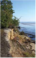
 Nanjemoy NRMA is situated
along the tidal Potomac River on the Nanjemoy peninsula. The
majority of the property straddles Maryland Route 224 and has been
labeled one of the most ecologically and culturally
significant landscapes remaining in Maryland, as it
protects 1.2 miles of relatively undisturbed shoreline. The
waterfront portion of the property is entirely within the state’s
Critical Area and provides refuge for migratory waterfowl and wading
birds. It also contains an extensive network of tidal and non-tidal
wetlands and secluded bays that protect bay grasses, which in turn
clean the Bay and provide habitat for numerous fish and invertebrate
species.
Nanjemoy NRMA is situated
along the tidal Potomac River on the Nanjemoy peninsula. The
majority of the property straddles Maryland Route 224 and has been
labeled one of the most ecologically and culturally
significant landscapes remaining in Maryland, as it
protects 1.2 miles of relatively undisturbed shoreline. The
waterfront portion of the property is entirely within the state’s
Critical Area and provides refuge for migratory waterfowl and wading
birds. It also contains an extensive network of tidal and non-tidal
wetlands and secluded bays that protect bay grasses, which in turn
clean the Bay and provide habitat for numerous fish and invertebrate
species.
The area is also almost completely forested, comprised
of mixed hardwoods such as white oak and red maple, which extends
off-site into the Nanjemoy Creek watershed. As a whole, it provides
contiguous forest that certain sensitive wildlife species require
and has been designated by The Nature Conservancy as high quality
habitat for Forest Interior Dwelling Species (FIDS). There are a few
small areas that were cleared as recently as 10 to 20 years ago;
these have begun to regenerate with early successional species such
as loblolly pine.
This pristine, diverse area provides protection for
several rare, threatened and endangered species. In 2003, DNR’s
Natural Heritage Program identified at least two active bald eagle
nests on the property. The worm-eating warbler, believed to be the
state’s most area-sensitive species, has also confirmed to be
breeding on site.
Historic Treasures
 Nanjemoy NRMA’s
cultural and archeological resources are equally as
significant. Archeologists have found traces of prehistoric
Native American cultures dating back 12,000 years. These artifacts
offer rare insight into indigenous cultures prior to European
settlement.
Nanjemoy NRMA’s
cultural and archeological resources are equally as
significant. Archeologists have found traces of prehistoric
Native American cultures dating back 12,000 years. These artifacts
offer rare insight into indigenous cultures prior to European
settlement.
More recently, the area figured predominantly in
colonial history, the American Revolution, the Civil War, and World
War I. During the Civil War, Union General Joseph Hooker had
extensive operations around Liverpool Point, Douglas Point, and the
Mallows Bay area.
During World War I, a plan called for the building and
launching of 1,000 wooden steamships to carry troops and cargo to
Europe; however, by the end of the war, not one had made the
crossing. Years later, at least 88 of the wooden steamships were
sunk at Mallows Bay and in the decades since, have become an
integral part of the natural ecosystem as artificial reefs. Today,
Mallows Bay is recognized as the largest sunken wooden ship
graveyard in the Western Hemisphere.
In 2005, the BLM and the William and Mary Center for
Archaeological Research (WMCAR) in Williamsburg, Virginia, performed
an archeological investigation of an 18th-century farmstead located
within the NRMA. The Chiles Homesite was determined eligible for the
National Register of Historic Places.
Due to the breadth and diversity of this area’s
natural and cultural resources, it’s no wonder so many sought its
protection!
Three
Decades of Preservation Efforts
Protection of
the Nanjemoy began in the 1970s when local citizens successfully
fought and won a legal case to prevent construction of a nuclear
power plant along the Potomac River. In the late 1990s, a gravel
mining company purchased the property and submitted a proposal to
quarry in the area. Again the local citizens rallied, and in 2000,
DNR, BLM, the Commissioners of Charles County and The Conservation
Fund (TCF) signed a cooperative initiative to provide a coordinated
strategy for land acquisition, long-range planning, community
involvement and ongoing stewardship. In 2001, DNR and BLM jointly
purchased the 1,921 acres that now constitute Nanjemoy NRMA.
Today, the approved management plan will provide the
area with a continuation of this unique partnership, by delegating
management responsibilities to three levels of government: BLM, DNR
and Charles County. It also provides guidance on the types of
activities that will be allowed, where they will occur, when they
will be phased in and how they will be managed over the next 10 to
15 years.
A Recreational
Resource
 Through a long-term lease with DNR,
most of the more intensive recreational infrastructure and activities will be provided by Charles
County. The County will lease (from DNR) and manage approximately
185 acres near Mallows Bay to utilize as a waterfront park. By
summer of 2006, the County hopes to have improved road access and
constructed a single-lane motorized boat launch that will provide
much-needed access to the Potomac River mainstem.
Through a long-term lease with DNR,
most of the more intensive recreational infrastructure and activities will be provided by Charles
County. The County will lease (from DNR) and manage approximately
185 acres near Mallows Bay to utilize as a waterfront park. By
summer of 2006, the County hopes to have improved road access and
constructed a single-lane motorized boat launch that will provide
much-needed access to the Potomac River mainstem.
Plans for next year also include construction of a
non-motorized canoe/kayak launch to the Potomac River Water Trail,
installation of an interpretative/informational kiosk and portable
restroom facilities, and construction of picnic pavilions. During
later phases, preliminary facilities will be improved (the portable
restroom will become a permanent building, etc.), accessible parking
and trails will be added to provide access for people with
disabilities, and camping sites and a small visitor center may be
added if and when demand is evident.
DNR and BLM will also provide for public access but
will primarily manage the remaining 1,736 acres of the property to
maximize protection of natural and cultural resources. Trails will
connect areas throughout the NRMA and provide three pedestrian
access points to the Potomac River. The BLM will also create an
accessible interpretative trail to access the archeological remains
of the Chiles Homesite. DNR will manage hunting on the property and
plans to create an environmental restoration area that will enhance
and restore habitat for several threatened and endangered species,
such as the leopard’s bane plant and the frosted elfin
butterfly.
Partners for
the Future
Despite the complexities of dealing
with different rules, policies and regulations, all three entities
have agreed to manage operations as seamlessly as possible so that
the public only experiences one managing entity, To accomplish this
goal, decision-making will be made through a new prototype
management team, consisting of DNR resource professionals from a
variety of disciplines as well as representatives from BLM and
Charles County. The team will meet regularly to coordinate and
create an annual work plan, pool resources, and assign
responsibility for upcoming infrastructure and activity
implementation.
Pooling resources is just one of the benefits of this
unique management approach. Cooperative agreements, such as BLM’s
Challenge Cost Share program, provides matching grants to implement
activities and build infrastructure; last year BLM funded and DNR
staff implemented invasive species removal throughout Nanjemoy NRMA.
The team will also be responsible for continuing to involve the
community with regard to the future use of this property.
Nanjemoy NRMA has and will continue to serve as an
innovative example of how to overcome funding and staffing
challenges to provide effective public land management for
Marylanders. By remaining in public hands, the areas’ unique natural
and cultural resources will remain forever protected … and not
forgotten.
Note: This article originally appeared in
the Winter 2006 issue of The Maryland Natural Resource Magazine.
