Monroe Run, Garrett County
The Monroe Run Natural Area contains an isolated stream valley covered with an assortment of eastern hemlock, birches and oaks. A five-mile trail snakes next to and over the coldwater stream which supports a healthy population of the uncommon native brook trout (Salvelinus fontinalis).
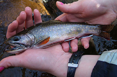
 Other mountain stream inhabitants include streamside
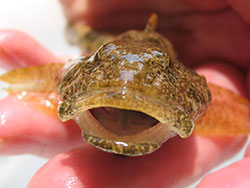
salamanders, such as the northern dusky salamander, as well as bizarre
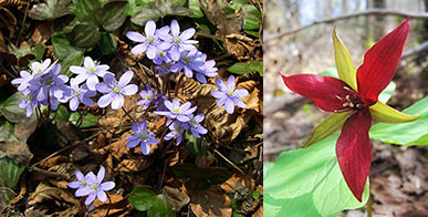
looking fish called sculpins. These small, bottom-dwelling fish are colored much like the rocks that line the stream. In the spring, visitors can enjoy a persistent background chorus of forest interior dwelling birds as well as an incredible display of wildflowers. Some of the early spring wildflowers include blue cohosh, wake robin trilliums, spring beauties, Dutchman's breeches, yellow trout lilies and round-lobed hepatica. Most of these wildflowers are known as spring ephemerals. They bloom and fruit from early to mid-spring before the trees leaf out. This timing allows these exceptional flowers to take full advantage of the sunlight.
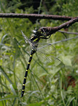 In the headwater area of the stream, near the upper trailhead, the steep gradient causes the stream to cascade over rocks as it emerges from a natural boulder garden. Spring seeps and small tributary streams support an exceptional diversity of salamanders as well as rare species such as the Endangered southern water shrew (Sorex palustris punctulatus). Despite this tiny insectivore's mouse-like appearance, it is not related to rodents at all. Uncommon and brightly colored tiger spiketails (Cordulegaster erronea) can be seen patrolling the stream. The intact forested watershed harbors these species and many more. Monroe Run Natural Area contains over 1,400 acres of forest within Savage River State Forest, the largest state forest in Maryland. Savage River State Forest is managed by the Maryland Forest Service.
A Plethora of Plethodontids
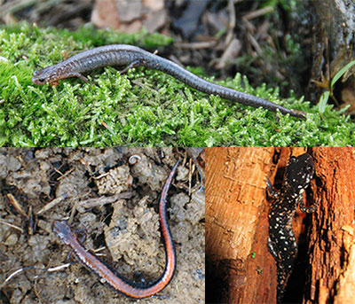
One of the hillsides adjacent to Monroe Run supports three species of woodland salamanders (plethodontids). This assemblage is unusual as two of the species – the eastern red-backed and the valley and ridge – rarely occur together. Eastern red-backed salamanders have a distinctive red stripe along the back and tail. Some lack most or all of the red pigmentation and are sometimes known as "leadbacks." Strongly resembling the leadback, the valley and ridge salamanders are deep brown in color, with scattered white spots and brassy flecks. The slimy salamander is the third woodland species in this area. This well-named plethodontid has tail glands that secrete a sticky substance when the animal is handled roughly.
Alien Invasion
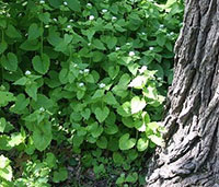 Garlic mustard, photo by Wikimedia CommonsThe rich soils which support an array of spring wildflowers along Monroe Run also support several invasive plant species. One of these invaders, garlic mustard, was intentionally introduced to the United States for its culinary qualities as a garlic-flavored herb packed with vitamins A and C. Unfortunately, this species spreads quickly within forests and progressively alters soil microbial communities, making the area less habitable for native plants. Japanese knotweed also has colonized the mouth of Monroe Run, and eradication efforts have nearly wiped this invasive species out of the Run. However, new invaders such as mile-a-minute have been discovered recently. Determined efforts to control and remove these and other invasive species will need to continue in order for the native wildflower diversity to persist.
 Click here for a Print Version of this map.
Monroe Run Natural Area
Special Note: Savage River State Forest is used seasonally by hunters.
Directions
From Frederick: Take I-70 west to I-68 at Hancock. Continue on I-68 about 60 miles to Exit 22. Turn left (south) onto Chestnut Ridge Road and go 2.7 miles to the T-junction at New Germany Road. Turn left and follow New Germany Road about 5 miles to the junction with Big Run Road. From here, either continue straight almost 3 miles to the upper parking area or turn left and head downstream on Big Run Road 4.5 miles to the lower stream crossing of Monroe Run. Continue another 0.5 mile to the end of Big Run Road, turn left and look for signs to the parking area.


Driving directions and aerial views open with Google Maps. For the aerial view button, if an aerial view does not open by default, click on the Satellite icon in the upper right corner and Google Maps will switch to an aerial view of the Natural Area.
