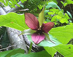
 Travel back in time with a visit to Lostland Run Natural Area. Located in Potomac State Forest, this Natural Area reflects how this rugged mountain country looked and felt 500 years ago. The folded landscape of ravines and coves and sandstone outcrops supports a blend of old-growth eastern hemlock, hardwood forests, dry oak-pine habitats and mesic deciduous forests. Lostland Run itself is a clear, cold mountain stream; the 3.5 mile trail following the stream, including a suspension bridge crossing, affords views of magnificent waterfalls and the confluence with the Potomac River. In the spring, ephemeral wildflowers make a brief appearance, taking advantage of the sunshine not yet blocked by tree leaves. Trilliums, Jack-in-the-pulpit, and jewelweed dot the steep slopes and streamsides; by June, the mountain laurel has filled the air with a delicate perfume.
Although much of the soil is acidic in nature, there are pockets of basic microhabitats; the calcareous cliff crevices support the beech fern, usually found in rich woods. The diverse forest structure helps to maintain the cold-water characteristics of the Run by providing temperature control from the shade, flow control by interception of rain-water and erosion control from the roots that hold the soil. Thanks to these processes, and with a little help from people, this stream is home to several fish species, including Maryland's native trout, the brook trout. But it wasn't always like this.
Acid Mine Damage
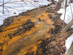
 Lostland Run was once degraded by acid mine drainage from abandoned coal mines in its upper watershed. Coal mining in western Maryland began in the early nineteenth century. Once coal was extracted from deep, underground mines or extracted from open pit strip mines, many of the areas were abandoned. Drainage from these abandoned mines is dangerously acidic and contains high levels of iron oxides and sulfates. As a result, many streams in western Maryland were affected by acid mine drainage (AMD), creating inhospitable conditions for aquatic species. To remediate the effects of AMD, devices called lime dosers were installed along waterways such as Lostland Run. The lime doser periodically adds pulverized limestone to the water. As a result, the pH of the water has increased and fly fishermen are once again plying the pools and riffles of this Run for brookies. A lime doser is clearly visible from the road.
Psych!
Along the edges of more open areas, woodlands and rugged slopes, wind the tendrils and heart-shaped leaves of the pipevine (Aristolochia macrophylla, Threatened). The unusual flower gives this plant another common name, Dutchman's-pipe. The squat, curled, tube-shaped blossoms appear in late spring and mid-summer, during which time this plant plays host to the caterpillars of the pipevine swallowtail butterfly. That iridescent flash of blue on the hindwing isn't just pretty; it is a warning to predators. This species (in both caterpillar and adult forms) is toxic to predators, thanks to the caterpillar's ingestion of toxic compounds from the pipevine. Other blue and black swallowtail species, like the spicebush and black swallowtails, take advantage of this. Because these imposters mimic the coloration of a toxic butterfly, would-be predators treat them with caution and leave them alone, even though they do not ingest toxic compounds from their host plants and are therefore not toxic.
Boreal Relicts
Living beneath the boulder fields and rock scree within the Natural Area are two rare small mammals, the southern rock vole (Microtus chrotorrhinus carolinensis) and long-tailed shrew (Sorex dispar). These boreal relicts live in the moist, cool pockets of forest that are now isolated islands of colder habitats left from the Pleistocene Epoch. Also called the yellow-nosed vole, the southern subspecies of rock vole is now cut off from its northern relatives by the lack of high mountain habitat in Pennsylvania. Further south, it lives at increasingly higher elevations and can be found as far south as northern Georgia's highest peaks, although the Great Smoky Mountains are the heart of its range. Southern rock voles feed on the shoots and berries of wildflowers. In contrast, the long-tailed shrew's narrow skull and buck teeth are designed to snatch insects and other prey from rock crevices.
|
Directions
From Frederick: Take I-70 west to I-68 at Hancock. Continue on I-68 about 60 miles to Exit 22. Turn left (south) onto Chestnut Ridge Road and go 2.7 miles to the T-junction at New Germany Road. Turn left and proceed about 10 miles to MD 495 (Bittinger Road). Bear left, continue about 7.5 miles to the T-junction, and turn right to stay on MD 495 (now Swanton Road). Go about 5.8 miles to Main Street and turn left. After nearly 7 miles (the road name changes several times), turn left onto Lost Land Run Road. The upper parking area is on the right in about 0.45 miles. To reach the lower parking area, continue another 2.6 miles to the end of the road.


Driving directions and aerial views open with Google Maps. For the aerial view button, if an aerial view does not open by default, click on the Satellite icon in the upper right corner and Google Maps will switch to an aerial view of the Natural Area.
 |