Cat Rock & Bob's Hill, Frederick County
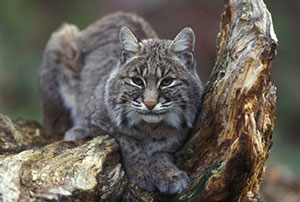
 A vigorous one and a half mile hike up the slope of Catoctin Mountain to the summit of Cat Rock (elev. 1,560 feet) yields the reward of an unforgettable view of the Blue Ridge Mountains and Frederick Valley. Although no one knows for sure, Cat Rock got its name either from its resemblance to a cat or from the fact that bobcats have been seen there. At Cat Rock's peak, the quartzite outcrop is extensive and spectacular, featuring jagged cliffs with a jumble of giant boulders below, forming an intricate network of caves and deep crevices. The dry, exposed rocks support little vegetation, but do feature a variety of colorful lichens and mosses. The expansive forests surrounding these geologic wonders are maturing second growth. Historically, the trees were cut to support charcoal production at the Catoctin Furnace between 1776 to 1903.
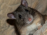
Cat Rock and Bobs Hill Natural Area lies mostly within Cunningham Falls State Park. This Natural Area is embedded within the largest contiguous tract of forest remaining in this part of Maryland. Large unbroken forest tracts are critical for a wide variety of species that are otherwise uncommon in the State. These forest dwelling species include American black bear, bobcat and the bristly North American porcupine, as well as many birds, such as ovenbird and broad-winged hawk. The combination of a large forest tract with an extensive boulder field also provides core habitat for the Allegheny Woodrat (Neotoma magister), listed as Endangered in Maryland.
Cambrian Quartzite
The light gray rocks at the summit of Cat Rock and nearby Bobs Hill are quartzite – metamorphosed sandstone – originally deposited about 500 million years ago during the Cambrian Period. During much of that time, the seas teamed with life, but the land was mostly barren with only a few isolated microbial life forms existing. The quartzite rocks belong to the Weverton Formation, the primary ridge-forming unit of Catoctin Mountain and, to the west, South Mountain, the two main ridges in the Blue Ridge of Maryland.
The Real Pack Rat
 The Allegheny woodrat is a native mammal that lives in wild, remote cave and rock outcrop areas such as Cat Rock. Distinguished by its furry tail, white feet and belly, and chestnut tinged lower flanks, the Allegheny woodrat is not at all related to city rats. The woodrat's habit of storing large caches of nuts, fruits, leaves, and peculiar objects has earned it the nickname "pack rat." These cached objects, stored in piles called middens, are tucked within rock overhangs to support the woodrats through harsh winters.
Click here for a Print Version of this map.
Cat Rock & Bobs Hill Natural Area
Special Note: Cunningham Falls State Park is used seasonally by hunters.
Directions
From Frederick: At the junction of I-70 and I-270, take I-270 to US 15 and head north about 16 miles to Thurmont. Take the exit for MD 77 (W. Main Street) and turn right (west) at the end of the exit ramp. Follow MD 77 west nearly 2 miles to the parking area.


Driving directions and aerial views open with Google Maps. For the aerial view button, if an aerial view does not open by default, click on the Satellite icon in the upper right corner and Google Maps will switch to an aerial view of the Natural Area.
