The Drainage Network
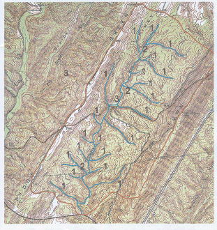
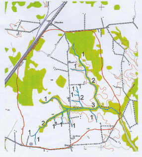
Streams can be described from an aerial view in terms of the drainage network. These networks can take on different patterns depending on topography, geology, and land cover.The numbers in the images below indicate the order of the stream segments in the red outlined watersheds.

The Terrapin Branch watershed has a high drainage density and long narrow shape because of its location between Green Ridge and Town Hill Ridge in western Maryland.
Wildcat Branch has a low drainage density and teardrop shape because of the flat topography of the eastern Coastal Plain. The channel orders are numbered for each network
Topography
Each of Maryland's physiographic provinces has it own distinguishing topographic characteristics. A preliminary overview of the topography of an area can provide useful information regarding drainage patterns, the relief of land surfaces, and channel gradient. General topographic information can also give an indication of stream energy characteristics. Steeper land surfaces have the potential to generate faster moving flows.

Regional Geology
General geologic information can provide a good historical background of a site. The presence of specific types of bedrock materials near the land surface can give a general indication of channel appearance and behavior.
Consider two streams on opposite sides of the state. From our basic understanding of the physiographic provinces in Maryland, we know that Watts Branch in the Coastal Plain does not have bedrock near the surface that controls the elevation of the channel bottom. There are also no large boulders or rocks in the channel.
Conversely, Bear Creek in the Appalachian Plateau has slope and dimensional characteristics that are governed by bedrock formations at the land surface. You can expect to find large rocks and boulders in the channel.
General knowledge of these natural physical differences is important for the assessment and comparison of the health of streams across the state.
Land Use Effects
Land cover changes can have significant influence on channel appearance and behavior because of the relationship with rainfall runoff, which can affect both stream stability and baseflow conditions.