ALERT:
Hallowing Point State Park Boat Ramp and Beach in Calvert County will be closed from Monday, November 11 through Wednesday, November 22 for dredging. Hallowing Point County Park will remain open.

Calvert County
Address: 6904 Hallowing Lane, Prince Frederick, MD 20678
Directions: From MD Route 2-4 south, head west onto MD Route 231. The entrance to the property is on the south (left) side of the road before to the bridge.
Phone: 443-510-9920 (Merkle duty phone 7 days a week 8AM – 4PM)
Headquarters Address:
Calvert Cliffs State Park
c/o Merkle Wildlife NRMA
11704 Fenno Road
Upper Marlboro, MD 20772
443-510-9920
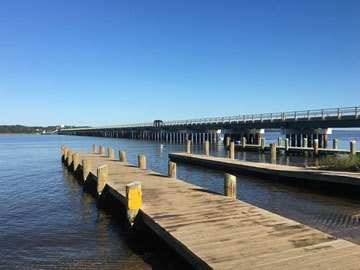
Hallowing Point Waterfront Recreation Area consists of approximately 15 acres of park property and includes two boat launches, parking, and a shoreline fishing area. The property is open from sunrise to sunset. The two boat launches are quite popular and can be rather busy on summer weekends because of the direct access to both the upper and lower sections of the Patuxent River.

Approximately 75 boat trailer spaces are available for parking, but the lot can fill to capacity on busy summer weekends because of the ramp’s popularity. Portions of the property have a sandy beach for fishing and picnicking. It is also a great location for launching canoes and kayaks with access to sheltered paddling locations.
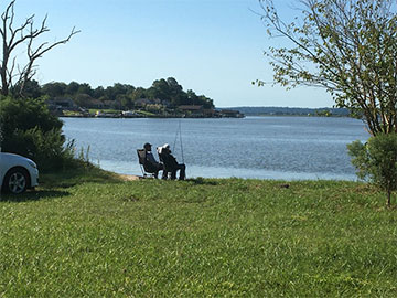
The park provides beautiful views of the Patuxent River and the Town of Benedict, and it is a great starting point for exploring the Patuxent River and accessing the Chesapeake Bay. Numerous coves and marshes on the river are teeming with waterfowl and other aquatic life, and provide a fascinating backdrop for waterfront excursions.
Rules and Regulations
- The consumption of alcohol at the Hallowing Point Waterfront Recreation Area is prohibited.
- All MD State Parks, including Hallowing Point Waterfront Recreation Area practice Leave No Trace.
- Trash cans have been removed to keep trash out of the river and improve the river’s beauty.
- A tidal saltwater fishing license is needed to fish; all other MD DNR fishing regulations apply.
Planning for the Future:
Background: Significant acquisitions of properties surrounding the boat launch have been completed and planning for redevelopment of the property as a waterfront park is underway. The Department of Natural Resources is working closely with Calvert County Parks and Recreation to develop a master plan for future improvements and additional recreational amenities on the property. There are four goals for the redevelopment of the Hallowing Point Waterfront Park that focus on environmental restoration and waterfront recreation:
- Restore natural resources on the site to improve water quality and habitat.
- Redevelop the property to provide office and maintenance facilities for the Natural Resources Police.
- Expand and enhance opportunities for passive recreation.
- Improve and increase access opportunities to the Patuxent River.
To effectively address these goals, plans for the property must include thoughtful site design, effective resource restoration and sustainable infrastructure. Site development will include construction of a new office building, maintenance building and parking for the Natural Resources Police. The plans for the remainder of the property will expand passive recreational facilities and water-oriented activities for Calvert County residents and visitors while restoring, protecting, improving and enhancing the existing natural, recreational and scenic resources of the area. To accomplish all of this, the Maryland Department of Natural Resources hired a consultant to put together two conceptual Master Plans based on these needs and public feedback from the first public outreach survey conducted in 2021.

1. Site Development Master Plan 1
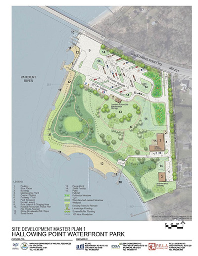
Plan 1 features a planted buffer consisting of a mixture of deciduous, flowering and evergreen trees along Route 231 and the adjacent neighborhood, as well as prominent pollinator meadow plantings by the park entrance and office buildings. The plan also features areas of mowed turf, including open spaces for visitor recreation and a picnic knoll. Trees will be strategically placed throughout the park to provide shade but will be thoughtfully located to maximize views of the water. All trees, shrubs and herbaceous plants will be native species selected to withstand seasonal inundation from periodic coastal flooding. New breakwaters, sills, tombolos and associated marsh planting will be installed to stabilize the shoreline and reduce sand accretion on the boat ramp. As part of the living shoreline restoration, some additional wetland plantings will be installed. Sandy beach terrain will remain along the shoreline in most areas. Walking trails are planned throughout the park, circling the picnic knoll and meandering through a shaded area by the shore.
The boat ramp area will be renovated, and a new ADA compliant kayak launch will be added. The boat trailer staging area is enlarged, and the launching area is reconfigured to improve traffic flow at the ramp. The new lot will have 20 car spaces as well as 70 boat trailer spaces, which is approximately the number of spaces that exist currently. The plan includes an option for a visitor contact station at the entrance to the boat ramp parking lot. Site development near the boat ramp includes a new, larger comfort station and site management building. Bicycle parking is located to the east of the visitor parking and is connected to the picnic knoll with a trail.
New facilities in the southeastern part of the site include a 5,000 SF office building to accommodate the Natural Resources Police (NRP) Southern Regional Facility, as well as an NRP Maintenance Building, Storage Yard and Pier. All new structures will be designed for energy efficiency and sustainability and will reflect the architectural style of waterfront buildings in the area.

2. Site Development Master Plan 2
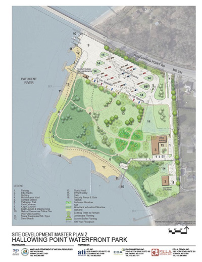
Plan 2 features much of the same landscaping as Plan 1, including a planted buffer along portions of Route 231 and Hallowing Lane. This plan has more open areas and turf than Plan 1 but does include canopy trees and understory trees throughout the park. The pollinator meadows in Plan 2 are located more centrally in the park, adjacent to the picnic knoll and surrounded by walking trails. The area next to the shoreline is more open, and the trail lay-out is more rectilinear. This plan includes ample areas of mowed turf and an area in the center of the site that would be appropriate for a sculpture or fountain. A living shoreline including wetland plantings will also be implemented in Plan 2, and areas of sandy beach will remain as well.
The boat parking area in Plan 2 is configured differently from Plan 1. The contact station orientation is changed, and parking aisles are laid out for the convenience of vehicles with boat trailers. Based on this design, operators of vehicles with trailers will not have to back out when leaving the lot. Plan 2 would include 68 boat trailer parking spaces and 20 car parking spaces. The boat ramp will also be renovated, and an ADA-compliant kayak launch will be added. The comfort station in Plan 2 is located slightly closer to the boat ramp, but farther from the bicycle racks. Natural Resources Police will have a pier for water access needs in Plan 2 as well. New breakwaters to reduce erosion and sand accretion will also be installed in Plan 2.
Thank you to everyone who participated in our public outreach survey. Stay tuned for Hallowing Point Waterfront Park site redevelopment updates.