DNR’s Chesapeake & Coastal Service participates in the collection of data to better inform decision-making in the face of climate change. Maryland’s Chesapeake Bay National Estuarine Research Reserve (CBNERR-MD/The Reserve) is a sentinel site for climate change and contributes information that informs coastal management issues at the local, regional, and national scale.
What is a sentinel site?
Just like a canary in a coal mine, sentinel sites signal risks and changes to our coastal wetlands under a changing climate. These discrete locations have the operational capacity for intensive study and sustained observations to detect and understand changes in the ecosystems they represent. Currently, CBNERR-MD’s Jug Bay component on the Patuxent River is a fully operational sentinel site. Over the next two years, with additional support from NOAA, the Reserve will be establishing its Monie Bay component as a sentinel site. Monie Bay is located in Somerset County which is one of Maryland’s most vulnerable counties to sea level rise. This additional site will provide valuable data on how local marshes are changing over time and if they are resilient to environmental stressors such as sea level rise. Sentinel sites measure a variety of parameters including vegetation, water quality, and meteorological data. Regular surveying is also conducted as well as the installation of Surface Elevation Tables (SETs) which measure how marshes are rising or sinking.
What is a Surface Elevation Tables (SET)?
SETs are an important component to a sentinel site and over time provide valuable information on the health of the marsh. SETs measure elevation change in the marsh both above ground (sediment deposition or erosion) and below ground (root growth, decomposition, compaction). These structures are installed and measured multiple times a year to better understand seasonal influences on the marsh system. SETs are often surrounded by boardwalks to prevent humans from disturbing the surface which would skew the data. Over time, we can compare how the marshes are keeping pace with the rate of sea level rise to understand if our marshes will survive, migrate, or disappear. To learn more about SETs and to see how they work, check out this short video:
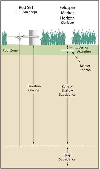
Image courtesy of (https://www.pwrc.usgs.gov/set/theory.html)
Chesapeake Bay Sentinel Site Cooperative
Sentinel Sites can tell us what is happening at a specific sites, can be used to inform and improve models and tools, and when linked together can show us what is happening at a regional scale. CBNERR-MD’s sentinel sites are part of the Chesapeake Bay Sentinel Site Cooperative which is working to do just that. The goal of the cooperative is to provide information to Chesapeake Bay communities and managers who need to address challenges such as storm flooding, long term, local sea level rise, barrier island movement, degraded water quality, and wetland loss. The information will also be useful to federal and state restoration planners and living resource managers who are addressing these challenges. For more information on the Chesapeake Bay Sentinel Site Cooperative: http://oceanservice.noaa.gov/sentinelsites/chesapeake.html

