The printed version of the Code of Maryland Regulations (COMAR) is the official and enforceable text. Only the official text may be judicially noticed under Courts and Judicial Proceedings, Section 10-203, Annotated Code of Maryland. For the complete, searchable, text of these regulations click here to access the Maryland Division of State Documents.
08.02.01.06 - Code of Maryland Regulation
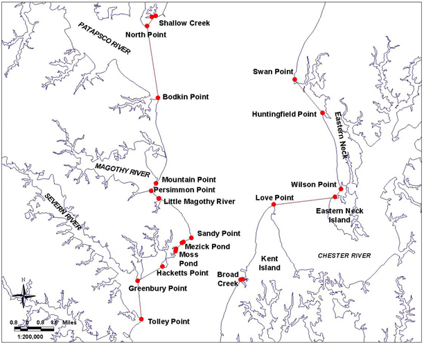
Bay Definition, Map No. 5
.06 Dividing Lines of the Chesapeake Bay, Sounds and Straits.
A. The boundaries set forth in §B of this regulation are designated as official dividing lines of the Chesapeake Bay, sounds and straits.
B. Any creek, cove, or other tributary less than 100 yards in width that intersects any segment of the following delineating lines shall not be a part of the described area.
(1a) Chesapeake Bay, Western Shore. - Description reads south to north.
Continued south on bay Map #3.
...then running northerly along shore to a point at or near Tolley Point, defined by Lat. 38°56.48' N and Long. 76°27.02' W; then running approximately 355° True to a point at or near Greenbury Point, defined by Lat. 38°58.49' N and Long. 76°27.26' W; then running approximately 60° True to a point at or near Hacketts Point defined by Lat. 38°59.22' N and Long. 76°25.61' W; then running northeasterly along shore to a point at or near the southerly entrance of Moss Pond, defined by Lat. 39°00.01' N and Long. 76°24.71' W; then running approximately 5° True to a point at or near the northerly entrance of Moss Pond, defined by Lat. 39°00.14' N and Long. 76°24.69' W; then running northeasterly along shore to a point at or near the west entrance of Mezick Pond, defined by Lat. 39°00.45' N and Long. 76°24.28' W; then running approximately 55° True to a point at or near the easterly entrance of Mezick Pond, defined by Lat. 39°00.49' N and Long. 76°24.19' W; then running easterly along shore to a point at or near Sandy Point, defined by Lat. 39°00.70' N and Long. 76°23.67' W; then running northwesterly along shore to a point at or near the south entrance of the Little Magothy River, defined by Lat. 39°02.76' N and Long. 76°25.79' W; then running approximately 274° True to a point at or near the north entrance of the Little Magothy River, defined by Lat. 39°02.76' N and Long. 76°25.82' W; then running northwesterly along shore to a point at or near Persimmon Point, defined by Lat. 39°03.16' N and Long. 76°26.33' W; then running approximately 34° True to a point at or near Mountain Point, defined by Lat. 39°03.55' N and Long. 76°25.99' W; then running northerly along shore to a point at or near Bodkin Point, defined by Lat. 39°07.98' N and Long. 76°25.83' W; then running approximately 352° True to a point at or near North Point, defined by Lat. 39°11.72' N and Long. 76°26.53' W; then running northeasterly along shore to a point at or near the west entrance of Shallow Creek, defined by Lat. 39°12.19' N and Long. 76°26.20' W; then running approximately 71° True to a point at or near the east entrance of Shallow Creek, defined by Lat. 39°12.25' N and Long. 76°25.95' W;...
Continued north on bay Map #6.
(1b)Chesapeake Bay, Eastern Shore. -
Description reads north to south.
...then running southerly along the shore to a point at or near Swan Point, defined by Lat. 39°08.89' N and Long. 76°16.69' W; then running approximately 141° True to a point at or near Huntingfield Point, defined by Lat. 39°07.13' N and Long. 76°14.85' W; then running southerly along the shore of Eastern Neck to a point at or near Wilson Point, defined by Lat. 39°03.19' N and Long. 76°13.66' W; then running approximately 216° True to a point at or near the northwest corner of Eastern Neck Island, defined by Lat. 39°02.77' N and Long. 76°14.05' W; then running approximately 263° True to a point at or near Love Point, defined by Lat. 39°02.40' N and Long. 76°18.16' W; then running southerly along the west shore of Kent Island to a point at or near the easterly entrance of Broad Creek, defined by Lat. 38°58.52' N and Long. 76°20.28' W; then running approximately 254° True to a point at or near the westerly entrance of Broad Creek, defined by Lat. 38°58.50' N and Long. 76°20.39' W; then running southerly along the west and south shore of Kent Island...
Continued south on bay Map #4.
