Linking communities and marshes in the midst of change
 The Deal Island Peninsula in Somerset County is a unique location in the Chesapeake landscape and is dominated by salt marsh and home to approximately 1000 residents. Due to its low-lying nature it is particularly susceptible to flooding, storm events, and sea level rise. The CoastSmart Communities Program and the Chesapeake Bay National Estuarine Research Reserve are partnering with the University of Maryland, Residents and Community members to increase the resilience of the Deal Island communities and marshes.
Currently, an Integrated Coastal Resiliency Assessment (ICRA) is being conducted for the Peninsula. The ICRA is bringing together scientific, technical, and local community knowledge and experience to assess how best to enhance the resilience of the Deal Island Peninsula. The ICRA will identify a range of adaptation and restoration options for reducing community and ecological vulnerabilities to coastal flooding, storms, and erosion now and over the next 10 years. The assessment will focus on 5 areas within the community identified by Community members, Resource managers, University scientists, and other project partners.
The ICRA is being conducted in three phases:
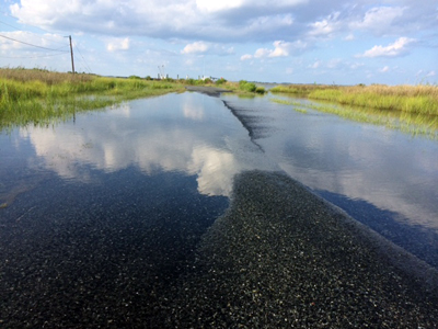 Phase 1: (Complete) A flood vulnerability study of the Peninsula now and into the future has been completed by the Eastern Shore GIS Cooperative (Salisbury University). A flood risk index that looks at flood risk now in 2015 and projected flood risk for the years 2020, 2030, 2040 and 2050. The index also provides information to look at the projected change in sea level over time and how flooding will change during different scenarios such as seasonal high, high tide events and during the 10% and 1% chance storm events. Based on the Phase I findings, community and project partners selected 5 areas representative of the Deal Island Peninsula to focus on in Phase 2 (see below). The selection of these areas has been informed by 1) geospatial mapping of current and future flood and sea level rise scenarios, 2) input from the stakeholder network and the broader community on known vulnerabilities, and 3) selection criteria developed by the Project team and stakeholders.
Phase 2: (In progress) This Phase will assess and seek to understand in-depth the vulnerabilities of each focus area through Collaborative Field Assessments (CFAs). This phase will identify, prioritize, and target restoration and adaptation strategies to implement in each focus area. A suite of strategies will be selected and we will determine how well each increases the resilience of the natural ecosystem and the community, and their feasibility.
Phase 3: This Phase will select and prioritize projects based on the strategies selected in Phase 2. During this phase, the project will also identify individuals to lead efforts and pursue funding for implementation.
This project is ongoing and because reducing risk to flooding is a complex issue it is the hope that the collaborative nature of this project can be used in other communities facing similar flood risks. For a more in-depth look at the project www.dealislandmarshandcommunityproject.org/
For More Information contact: Sasha Land at [email protected]
